All Activity
- Past hour
-
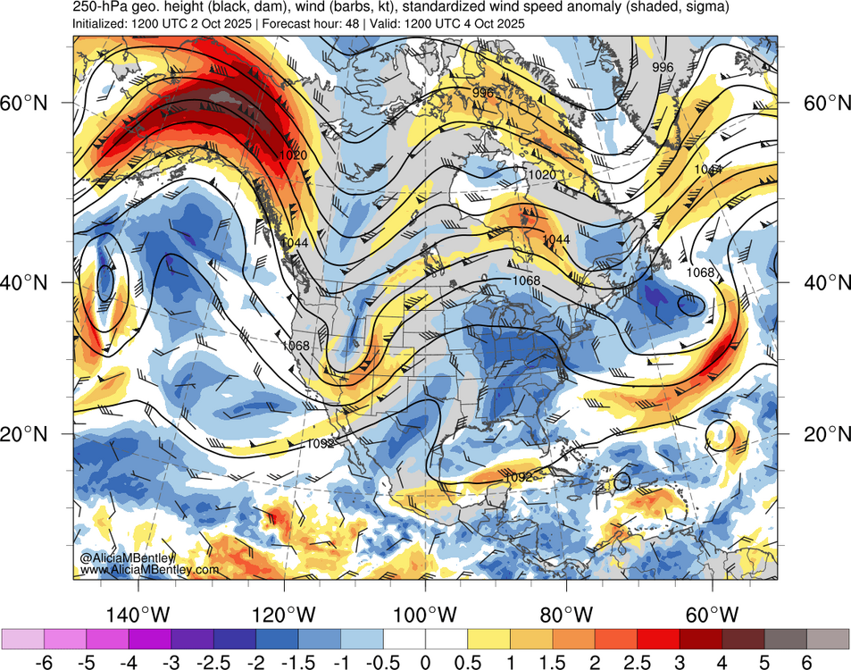
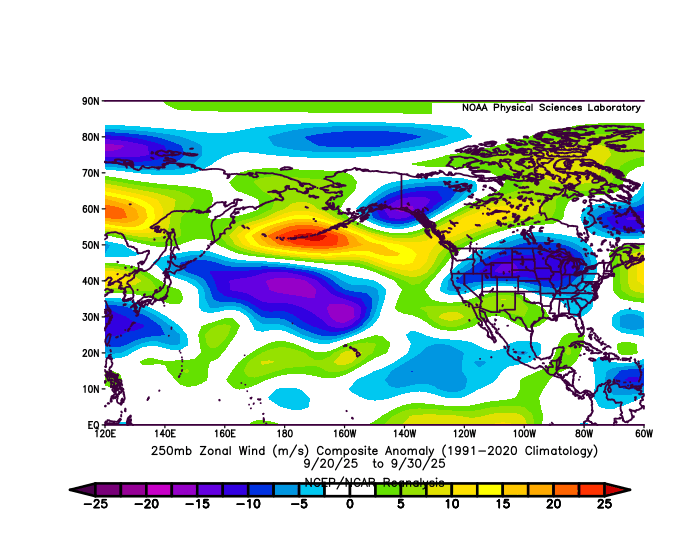
Yeah, the contrast between Siberia and the SSTs in the WPAC is the strongest on record for early October. It resulted in a 5 sigma jet streak out near the Aleutians recently. This has lead to the record warmth over North America from late September into early October.
-
Hey Charley, I don’t have a specific reference to post. Rather this is based on a pro-met who gives me this info. I asked him if he had a single source, but he gave me multiple sources. He believes in AGW but also believes that it is more beneficial than harmful due to significantly increased food supply. I don’t agree with his overly optimistic feeling because he downplays the rising sea level aspect, which I disagree with especially since I’m not too far from the coast and have followed the increased frequency of coastal flooding events. He lives in the Midwest, far from any ocean.
-
Southeast LA over into the Panhandle got 6-12" of snow last year. A new state record was set near Pensacola for 24hr snowfall. It was a freak event back in January
-
The message is clear - head to Florida if you want to see snow! What, did they get 1/8" of snow one year vs the normal 1/16" every five years which turned them into a snow town? Who made that map, terrible. Oh I see WaPo in the lower corner. That tracks.
-
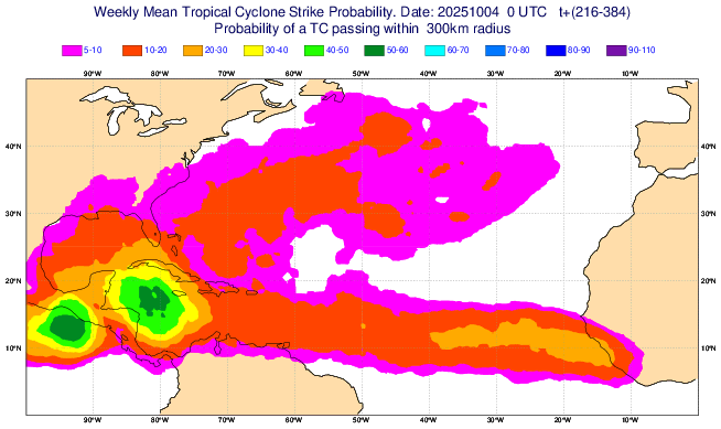
This is now Invest 95L: Tropical Weather Outlook NWS National Hurricane Center Miami FL 800 AM EDT Sun Oct 5 2025 For the North Atlantic...Caribbean Sea and the Gulf of America: 1. Tropical Atlantic (AL95): A broad area of low pressure associated with a tropical wave continues to produce a large area of disorganized showers and thunderstorms several hundred miles south-southwest of the Cabo Verde Islands. Environmental conditions appear conducive for additional development of this system, and a tropical depression is likely to form this week as the system moves quickly across the central tropical Atlantic, approaching portions of the Leeward Islands by the latter part of this week. * Formation chance through 48 hours...medium...40 percent. * Formation chance through 7 days...high...70 percent. @bigtenfan
-
Played a practice round there today ahead of next weeks Mid-Am. Definitely a nice track. Long-ish from the tips at just over 6800. Tree-lined but wide enough. (like Augusta really) Fastest greens I may have ever played on though. Anything downhill never stopped. Uphill was still fast. And everything broke twice as much.
-

Spooky Season (October Disco Thread)
Damage In Tolland replied to Prismshine Productions's topic in New England
Right thru end of month too - Today
-

Spooky Season (October Disco Thread)
CoastalWx replied to Prismshine Productions's topic in New England
What a stretch. Top 10 after top 10. Extended summer. -
Yup...yesterday in Brattleboro.
-
That’s my point. It was easier back during the colder climate era to pull off a series of epic years like that. I agree that it was an amazing run even during that era. But the colder climate made it possible. I am sure the posters around Boston would be happy seeing a winter or two during the remainder of the 2020s bouncing back closer to the long term average in the low 40s.
-

Central PA Fall Discussions and Obs
WxUSAF replied to ChescoWx's topic in Upstate New York/Pennsylvania
What an embarrassing loss. Just totally exposed as frauds. -
The seasonal models are showing more of an Aleutian ridge regime than an Alaskan ridge regime. Not saying they’re right, but it would fit -ENSO climo
-
Do you mind sharing the source website for deriving these graphs? I would like to look at a few stations further north and west of NYC.
-

Spooky Season (October Disco Thread)
HoarfrostHubb replied to Prismshine Productions's topic in New England
49 here in SVT. Off to get eggs -

Spooky Season (October Disco Thread)
moneypitmike replied to Prismshine Productions's topic in New England
I think it's called Indian Summer. -
55 now; going to be another beauty.
-
Spooky Season (October Disco Thread)
Damage In Tolland replied to Prismshine Productions's topic in New England
Low of 65 -

Spooky Season (October Disco Thread)
powderfreak replied to Prismshine Productions's topic in New England
Don’t worry, the time of getting 3” of snow and then 70 degrees a day later is coming up in December. -
Today was the first breezy day in a long time. It seems like the last month has been dead calm almost every day. It has been extremely warm, but it's very different than the heat a couple months ago. If the sun goes behind a cloud or the wind kicks up, it's suddenly comfortable. Also, by late afternoon it's already cooling off. By evening, it feels amazing. There is a big construction project by my house that has been ongoing since July, in which tens of thousands of yards of soil has been excavated and moved around. They have been very lucky to have such dry weather over the last several weeks. They are about to start work on the end of my street. Hopefully, they can get it done before the weather becomes more active.
-

2025 Atlantic Hurricane Season
WxWatcher007 replied to BarryStantonGBP's topic in Tropical Headquarters
That’s by far the worst spot too given the OHC and reduction in shear. There’s too much shear for the lemon areas in the Gulf right now, but the tropical Atlantic wave is likely to develop given how convectively active it continues to be and the CAG could very well produce 1-2 TCs (more likely 1 imo). -

October 2025 Discussion and Obs
BobbyHolikWillFindYou replied to wdrag's topic in New York City Metro
Plot twist...its all sleet. -
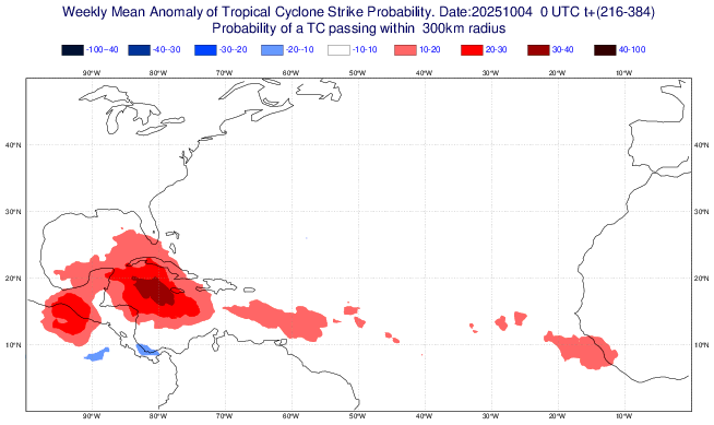
The latest Euro Weeklies are the most active yet in the W Caribbean for the week of 10/13-19 (if I were in the FL pen., especially S half, I’d be pretty concerned for midmonth): Forecast nearby TC probabilities: Forecasted anomalies vs 2005-24 climo: wow!
-
Yeah almost everything was still open. It was almost as busy there today as a summer day. Perfect weather for it. We always go a few times during July and August on Wednesdays because they have fireworks on Wednesday nights, but it's nice to go down there one more time during the early fall before things close down. Almost everything will be closing after next weekend. But anyway just to get back to what we were talking about with the Belmar forecast. I see Belmar had a high temp of 82 today, so we were right about the NWS forecast of 72 being ridiculously low. It felt like summer this afternoon walking up and down the Seaside Heights boardwalk.
-
The latest Euro Weeklies are the most active yet in the W Caribbean for the week of 10/13-19 (if I were in the FL pen., especially S half, I’d be a bit concerned for midmonth): Forecast nearby TC probabilities: Anomalies vs 2005-24 climo: wow!


-
Highs: EWR: 87 TEB: 86 New Brnswck: 86 LGA: 83 ISP: 83 TTN: 83 BLM: 82 PHL: 82 NYC: 82 ACY: 81 JFK: 78


