All Activity
- Past hour
-
Thanks yall. Spending my birthday weekend (and most of next week) at, you guessed it, a dance competition
-
warmest winter on record
-
Only thing to muck it up, would be debris clouds.
-
No I said after the 4th we cool off which looks on track. But still summer wx.
-
remember when nino summers were cool
-
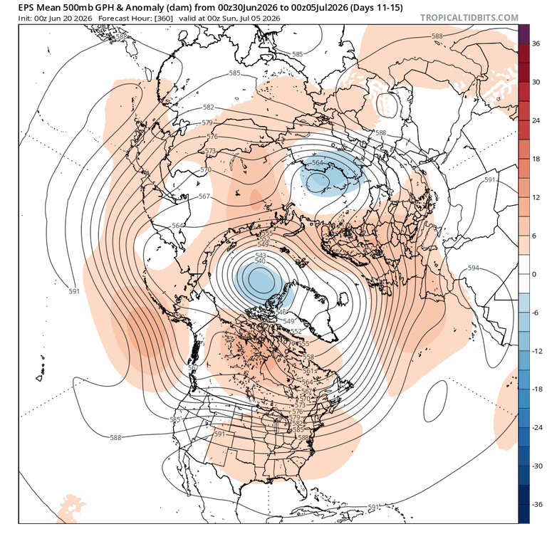
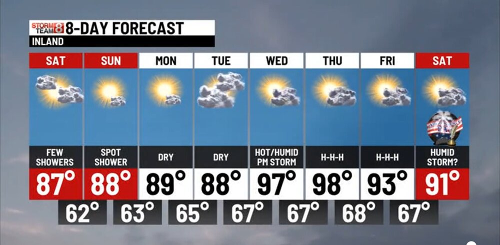
75 / 67 clouds - showers. Less than had been expected earlier in the week with general showers, light rain and occasional quick heavy shower with .10 - 0.45. Clears out tomorrow then the ridge buillds in by later Monday now centered a bit east with 850 temps >20c Tue - Sat peak heat 850 MB temps >22C Tue - Sat upper 90s / low 100s. Ridge >594 DM in the period with a bit of a pull back towards the late 4/5th but overall remaining warm - hot 7/5 - beyond. The risk of isolated or scattered showers the holiday weekend but overall 90% looking good. beaches and coast the seabreeze keeps the worst heat just back.
-

2026-2027 Super El Nino
bluewave replied to Stormchaserchuck1's topic in Weather Forecasting and Discussion
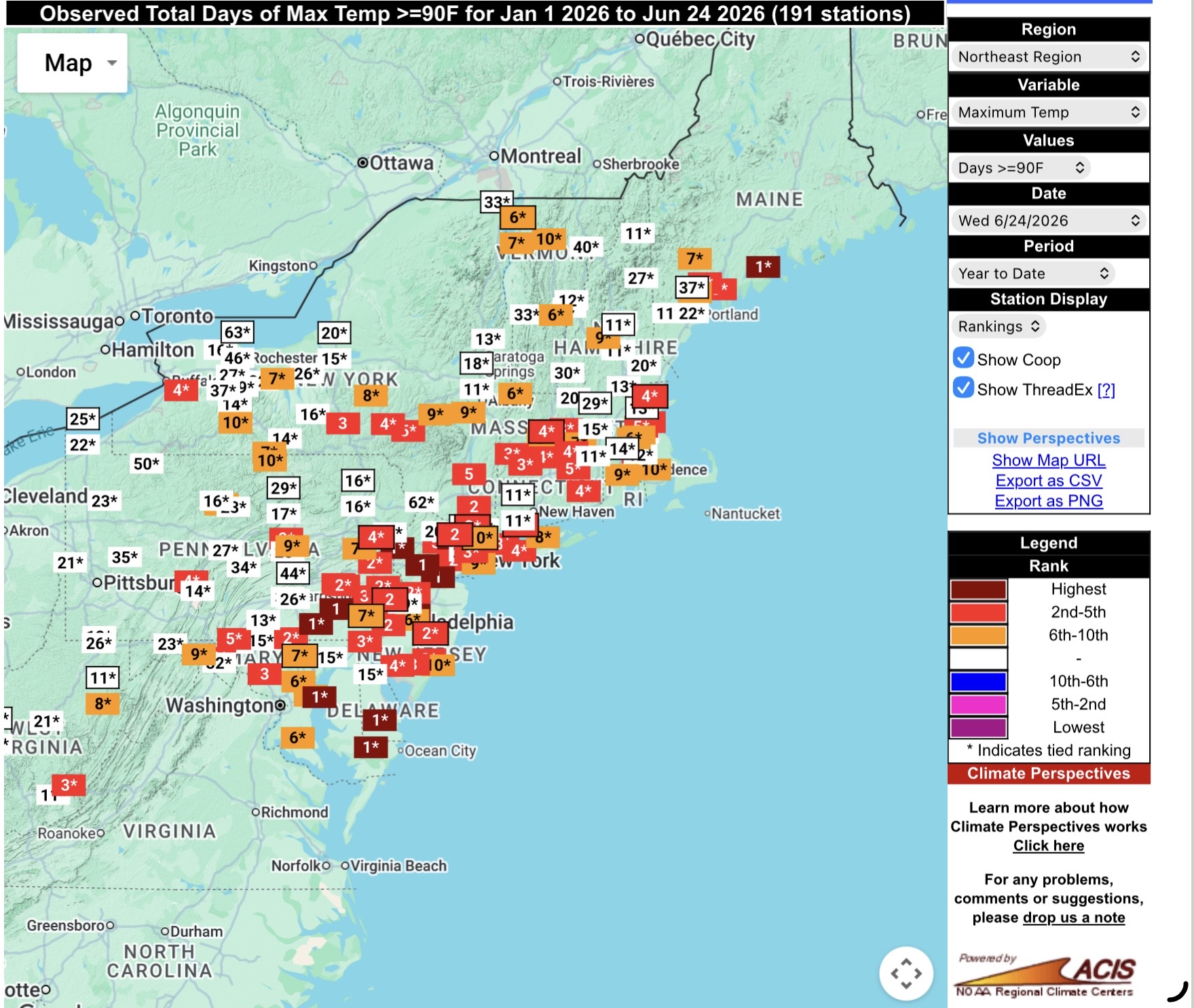
Your local area not really representative of the much warmer pattern experienced around the greater region from the spring into summer so far. Parts of NJ had early record 100° heat for May. Many local climate sites are currently in the top 5 for the most 90° days by June 24. But I agree with you that the pullbacks closer to average between the record heat surges are probably the developing El Nino influence. While super El Niños are a small sample size, none of the previous developing super El Niños came anywhere close to the number of 90° days so early in the season. Most of the shared top 5 years are La Niña, neutral, or weaker El Niños. Plus the warming climate is also influence increasing the 90° days counts.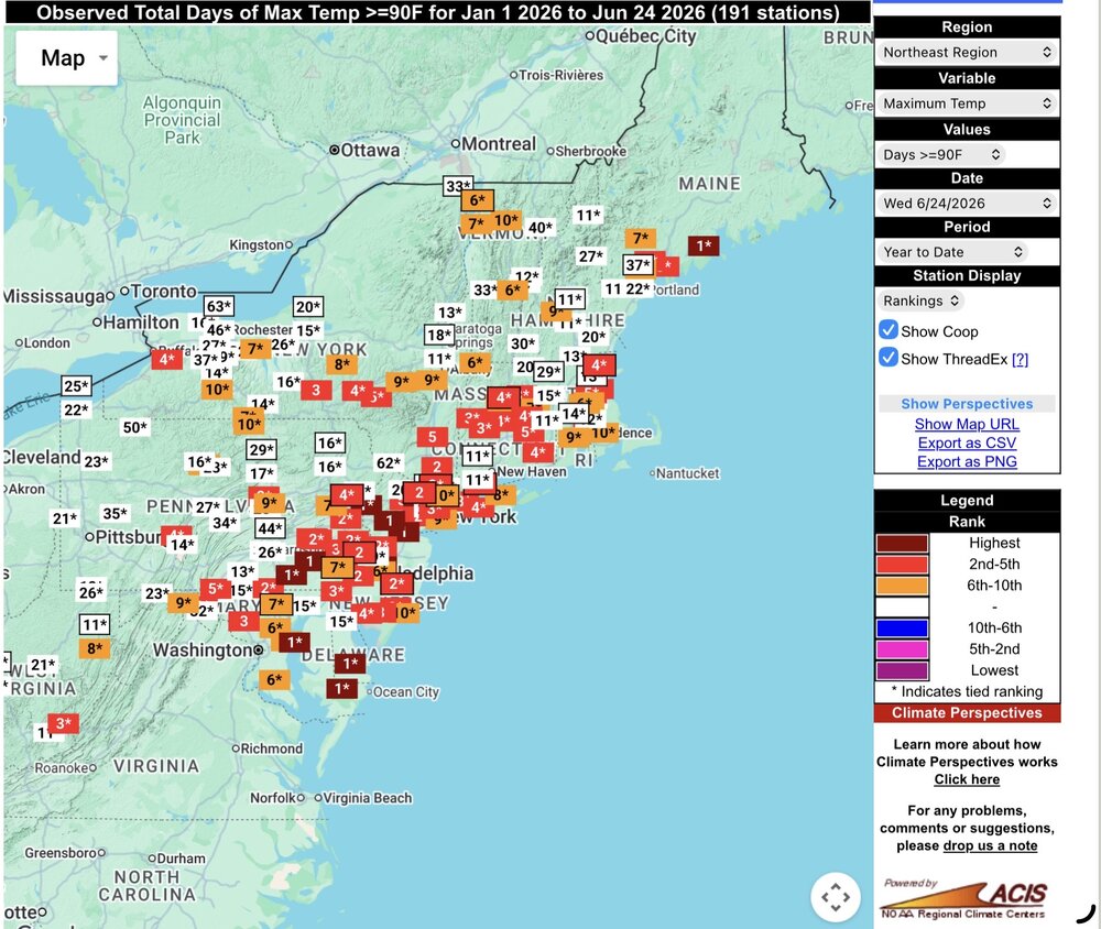
-
I have never played with a Vue. You have a console right? Does you have WeatherlinkIP that directly sends the data to your modem or do you download data to software on a PC?
-
Good thing I have no air conditioning!
-
i'm so glad climate change is not letting us have a cool nino summer
-
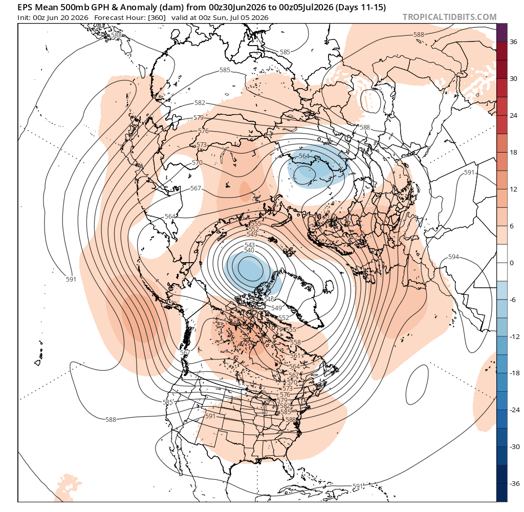
00z MEX is starting to pump those numbers up a bit to open July…BDL 98, MHT 97, LEB 95. I had a feeling we would trend that ridge axis more eastward with time like early June. The Labrador taint is more of a bully in April and May, but this time of year I take it with a grain of salt in the deep extended when there’s a pig ridge trying to build in. Obviously it’s New England and we can find a way to F up heat 6 ways from Sunday. I’ll be curious to see what happens after next weekend. Does the ridge still retro or does become more stubborn. We’ll probably knock heights back a bit either way, but do we reload the heat after that or go back to normal/seasonably warm?
-

Intermittent (but frequent) Bad Gateway 502 Errors
Kmlwx replied to Kmlwx's topic in Forum Information & Help
Seems MUCH better at time of this post (a little after 8am ET on Saturday). But wonder if once the site gets more traffic it will return. -

Junorch obs and discussion 2026
Damage In Tolland replied to Damage In Tolland's topic in New England
No let up in sight ! -
What a week coming up.

-
Miss south yesterday, north this morning, next batch tracking south again? Bring on the giga-Nino rains this fall…
-
National Weather Service
-
Junorch obs and discussion 2026
Damage In Tolland replied to Damage In Tolland's topic in New England
. Theres definitely a lot of psychological similarities between the two , and they both live in SE MA. Interesting… -

2026-2027 Super El Nino
mitchnick replied to Stormchaserchuck1's topic in Weather Forecasting and Discussion
Harrisburg Capital City Airport is -.8 thru June 26th. It's been closer to Niño around here. The heat waves this year have been transient or you wouldn't have a BN number thru the first 26 days of the month. Since this one won't start until Tuesday, the month will still likely end BN. My hunch is this heat will be transient again, but we'll have to see. -
Bring it.
-
Of course i have 2 softball games in the middle of the day thursday
-
Doughts can create that kind of a feedback loop for sure.
-

2026-2027 Super El Nino
snowman19 replied to Stormchaserchuck1's topic in Weather Forecasting and Discussion
In addition to the WWBs/westerlies we have been seeing since April, there has been a complete trade wind reversal in the equatorial PAC, at the surface and aloft, something you only see in the strongest El Niños The new DWKW that was spawned by the most recent WWB looks very impressive right now and there’s nothing to attenuate it as it moves east across the PAC, it should reach the South American coast sometime in August….I think +12 subsurface anomalies are very possible when it augments the already record warm anomalies (+9C) in the EPAC In addition to the record-breaking warmth in region 3.4, El Niño Costero continues to gain strength…. ^Translation: “@enfenperu raises - once again - its forecast regarding the magnitude of #ElNiñoCostero. The sum of the probability of a strong or extraordinary event exceeds 50% for each month between July and March 2027. This event would point to being on the scale of 1997-98 or 1982-83. There are no others at this level of magnitude.” -
This signal will only strengthen as we get closer. Many records will be shattered
-
Junorch obs and discussion 2026
Damage In Tolland replied to Damage In Tolland's topic in New England
Imma need your expertise to get this back online. It literally stopped connecting to wi fi and will not reconnect. Any thoughts? -
"The combination of strong subsidence, lack of clouds, dry ground, and a downslope low and mid level flow - could potentially yield a near historical heat event bringing very dangerous conditions. Some guidance is now forecasting a few disturbances in the NW-N flow aloft riding into the region by Friday and Saturday the 4th. This may be enough to trigger either widely scattered or scattered (20-30 percent chance) of afternoon or early nighttime thunderstorms perhaps bringing some temporary cooling."