All Activity
- Past hour
-

Central PA Summer 2025
Mount Joy Snowman replied to Voyager's topic in Upstate New York/Pennsylvania
Low of 70 and 4.07” of rain here. Honestly, I was expecting more but the late night stuff didn’t quite perform the way the earlier stuff did. Still, has to be one of my highest one-day totals on record, will check the spreadsheet later. Not loving the look for later today. We could really use a break over this way. -

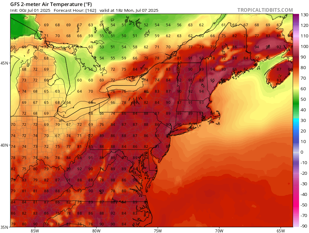
July 2025 Obs/Disco ... possible historic month for heat
512high replied to Typhoon Tip's topic in New England
Happy July warm weather crew! 73/70 heavy clouds -
 Violent thunder woke me up around 1am. Is fire island ok?
 -
-
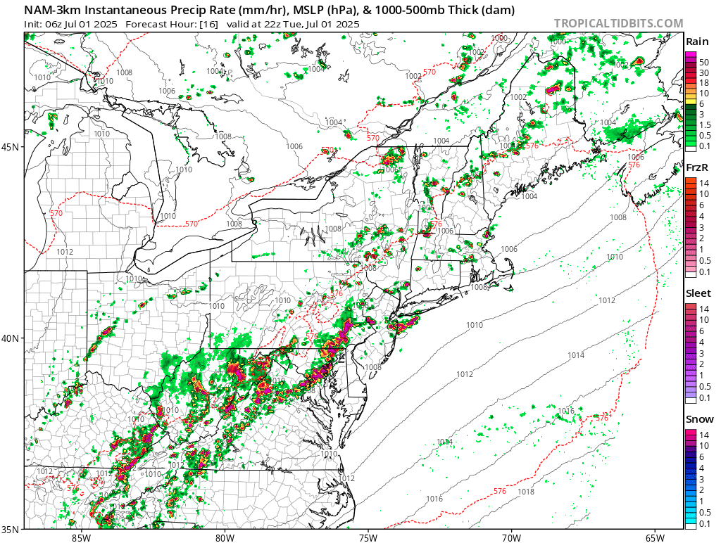
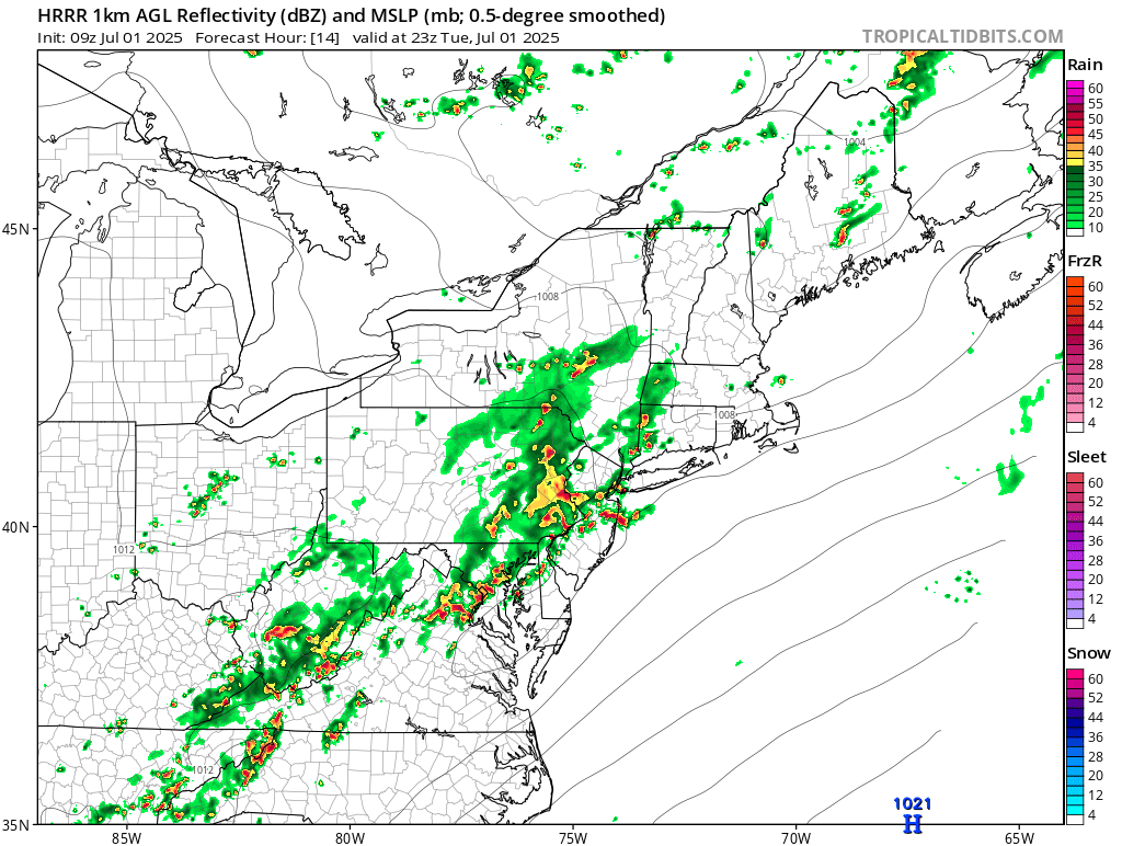
 Dissapointing die off near I80 overnight, after 2+ near Trenton and apparently 1-1.5 parts of southeast LI earlier today. This afternoon-night should be active with mesoscale SVR/FF reports. Leftover rain Wed morning LI-NJ. I probably wont be back on til late today.
 -
3K and HRRR showing an active afternoon into evening.

-

Summer 2025 Medium/Long Range Discussion
Spartman replied to Chicago Storm's topic in Lakes/Ohio Valley
https://x.com/WxRiskGrains/status/1939524075975581933 -

July 2025 Obs/Disco ... possible historic month for heat
Chrisrotary12 replied to Typhoon Tip's topic in New England
Can’t get thunderstorms over land anymore.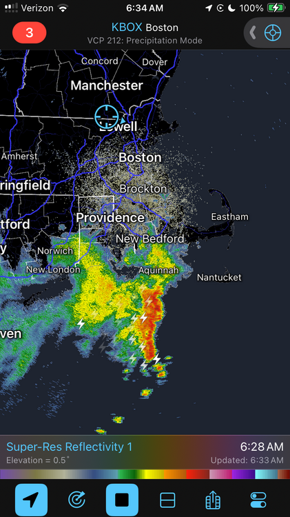
-
Another of meteorological summer, another month of relentless rain for 2025 (especially some days of biblical rainfall)
-
78/75
-

July 2025 Obs/Disco ... possible historic month for heat
CoastalWx replied to Typhoon Tip's topic in New England
Congrats Nantucket. -
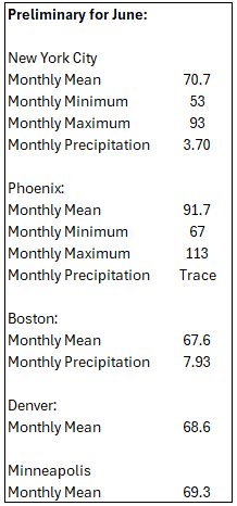
Finished the month with 6.21" of rain for this June, just 0.45" away from reaching the top 10 wettest Junes on record. Top 10 Wettest Junes (DAY) 1. 10.59" - 1958 2. 9.54" - 1980 3. 9.09" - 1903 4. 7.88" - 2015 5. 7.59" - 1924 6. 7.43" - 2017 7. 7.32" - 1902 8. 7.22" - 1932 9. 7.13" - 1928 10. 6.66" - 1986
-

July 2025 Obs/Disco ... possible historic month for heat
Damage In Tolland replied to Typhoon Tip's topic in New England
Steined this morning . Wonder how he’ll get us this afternoon? -
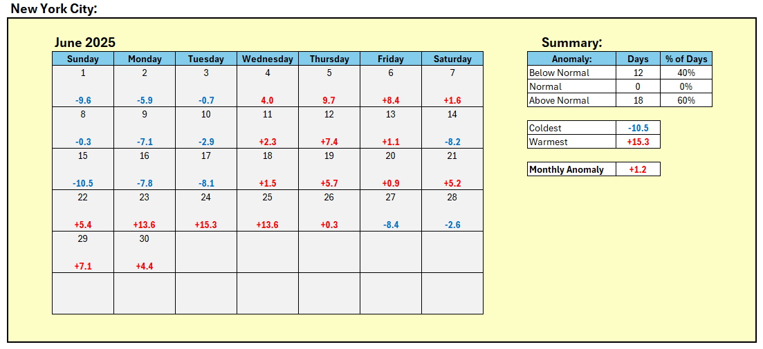
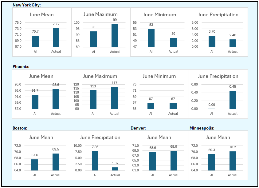
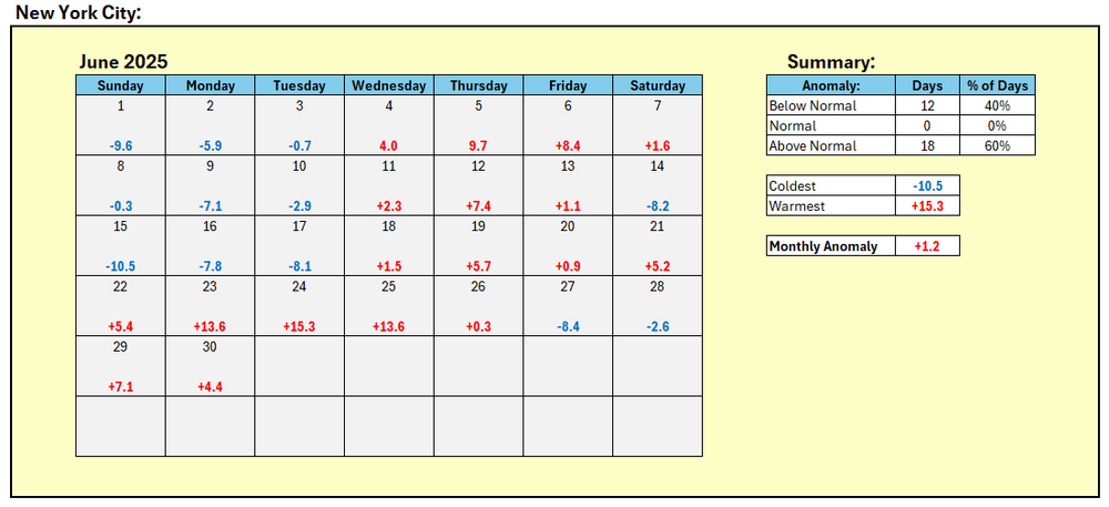
June Verification:
-
Loud, windy storms around 10:30-11 last night left exactly an inch. Tired of lawn mowing...as every year.
-
Updated Cansips just out, though dry for the winter, keeps it BN most areas north of the Mason-Dixon line. This is a link starting in November. Summer is reasonably tolerable over most of the conus too. https://www.tropicaltidbits.com/analysis/models/?model=cansips®ion=us&pkg=T2ma&runtime=2025070100&fh=4 500mb starting November https://www.tropicaltidbits.com/analysis/models/?model=cansips®ion=nhem&pkg=z500a&runtime=2025070100&fh=4 Enso starting November https://www.tropicaltidbits.com/analysis/models/?model=cansips®ion=global&pkg=ssta_noice&runtime=2025070100&fh=4
-
Final June numbers:
-
Updated Cansips just out, though dry for the winter, keeps it BN most areas north of the Mason-Dixon line. This is a link starting in November. Summer is reasonably tolerable over most of the conus too. https://www.tropicaltidbits.com/analysis/models/?model=cansips®ion=us&pkg=T2ma&runtime=2025070100&fh=4 500mb starting November https://www.tropicaltidbits.com/analysis/models/?model=cansips®ion=nhem&pkg=z500a&runtime=2025070100&fh=4 Enso starting November https://www.tropicaltidbits.com/analysis/models/?model=cansips®ion=global&pkg=ssta_noice&runtime=2025070100&fh=4
-
5.85 total rain for the month of June.
- Today
-

Summer 2025 Medium/Long Range Discussion
A-L-E-K replied to Chicago Storm's topic in Lakes/Ohio Valley
0z wasn't the worst in the world but definitely could use a nice wide spread MCS to soak the area instead of the spotty pop up stuff it looks we'll be getting -
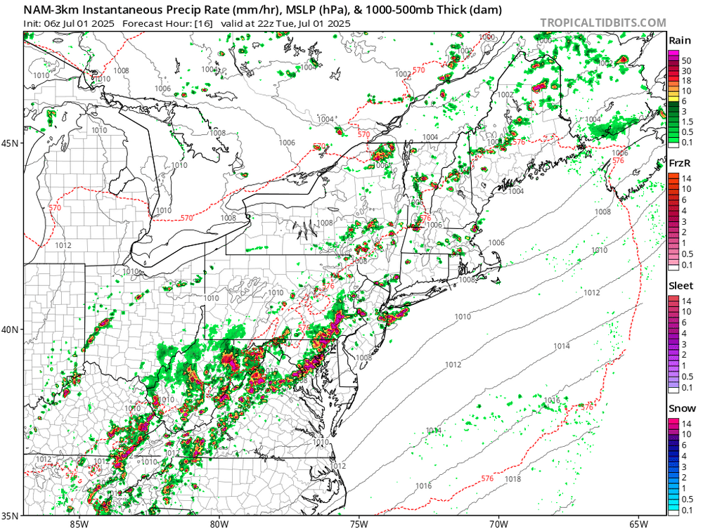
Moderate risk for excessive rainfall for much of the area and slight for the rest. Expect more flood watches. https://www.wpc.ncep.noaa.gov/qpf/excessive_rainfall_outlook_ero.php eta…flood watches were already hoisted
-

July 2025 Obs/Disco ... possible historic month for heat
Lava Rock replied to Typhoon Tip's topic in New England
Lots of beer Sent from my SM-S921U using Tapatalk -

July 2025 Obs/Disco ... possible historic month for heat
Torch Tiger replied to Typhoon Tip's topic in New England
Make em say ugh uggghh na na, na na
-
Hope everyone is safe and nobody gets flooded, These kind of storms are deceiving on the yearly totals. Mostly all run off
-
Hazardous Weather Outlook National Weather Service State College PA 439 AM EDT Tue Jul 1 2025 PAZ036-057-059-063>066-020845- Franklin-Dauphin-Lebanon-Cumberland-Adams-York-Lancaster- 439 AM EDT Tue Jul 1 2025 ...FLOOD WATCH IN EFFECT FROM 2 PM EDT THIS AFTERNOON THROUGH THIS EVENING... This Hazardous Weather Outlook is for central Pennsylvania. .DAY ONE...Today and tonight. Please listen to NOAA Weather Radio or go to weather.gov/StateCollege on the internet for more information about the following hazards. Flood Watch. Additionally, strong to severe thunderstorm wind gusts are possible this afternoon and early this evening. .DAYS TWO THROUGH SEVEN...Wednesday through Monday. The probability for widespread hazardous weather is low. .SPOTTER INFORMATION STATEMENT... Spotters are encouraged to report significant hazardous weather.