All Activity
- Past hour
-

Augdewst 2026: Summer's Last Stand
Damage In Tolland replied to Prismshine Productions's topic in New England
Whole thing looks meh with heavy rains E MA and ENY with very little storms anywhere tomorrow. More wx boredom -
Our last shot at any rain is 3 - 11 pm as the front approaches. After that, my 66% of normal August rainfall shrinks.
-

2026 Severe Wx - General Thread
SchaumburgStormer replied to largetornado's topic in Lakes/Ohio Valley
We got the record easy. Then we will smoke it with a random December tornado day. -

Augdewst 2026: Summer's Last Stand
CoastalWx replied to Prismshine Productions's topic in New England
Stein continues tonight -
Thanks Chuck! During July in Augusta County, I only received 62% of normal rainfall. During August, I have received 66% of normal thru 8-20.
-
The drought has really easied for most people expect for @EastCoast NPZ. He sent me a pick of his back yard yesterday

-
August 22 1910: Daylight is dimmed in Duluth due to smoke from Rocky Mountain forest fires. 1870: Downpours across southern Minnesota produce 5 inches at Sibley, and 3.49 at Ft. Snelling. Much of the wheat crop is damaged. For Saturday, August 22, 2026 1816 - The growing season for corn was cut short as damaging frosts were reported from North Carolina to interior New England. (David Ludlum) 1923 - The temperature at Anchorage, AK, reached 82 degrees, a record for August for the location which was later tied on the 2nd in 1978. (The Weather Channel) 1987 - A cold front lowered temperatures 20 to 40 degrees across the north central U.S., and produced severe thunderstorms in Ohio and Lower Michigan. An early morning thunderstorm near Sydney MI produced high winds which spun a car around 180 degrees. (The National Weather Summary) (Storm Data) 1988 - Afternoon highs of 88 degrees at Astoria, OR, and 104 degrees at Medford, OR, were records for the date, and the number of daily record highs across the nation since the first of June topped the 2000 mark. (The National Weather Summary) 1989 - Evening thunderstorms in the central U.S. produced golf ball size hail at May City IA, and wind gusts to 66 mph at Balltown IA. Lightning struck a barn in Fayette County IA killing 750 hogs. Evening thunderstorms in Montana produced wind gusts to 70 mph at Havre. (The National Weather Summary) (Storm Data) 1992 - Hurricane Andrew makes landfall in Southern Florida as a Category 5 storm with wind guests estimated in excess of 175 m.p.h. Estimated damages exceeded $20 billion, more than 60 people were killed and approximately 2 million people were evacuated from their homes. (University of Illinois WW2010) Observances: 22 Sat National Tooth Fairy Day 22 Sat World Plant Milk Day 22 Sat Be An Angel Day 22 Sat Folklore Day 22 Sat International Day Commemorating the Victims of Acts of Violence Based on Religion or Belief 22 Sat National Bao Day 22 Sat National Surgical Oncologist Day 22 Sat National Take Your Cat to the Vet Day 22 Sat Never Bean Better Day 22 Sat Rainbow Baby Day 22 Sat National Pecan Torte Day
-
What's everyone complaining about, pouring 0.82"
-
I believe that is were the NAM having the line set yesterday or close to it.
-
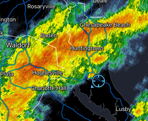
That's training too. Probably a couple inches in some places if it holds together.
-

Central PA Summer 2026 Discussion/Obs Thread
Mount Joy Snowman replied to Voyager's topic in Upstate New York/Pennsylvania
Two confirmed tornados, with the eastern York one being an EF2 and Columbia EF1. What a day. Public Information Statement National Weather Service State College PA 915 PM EDT Fri Aug 21 2026 ...NWS Damage Survey for 08/20/2026 Tornado Event... ..Eastern York County Tornado... Rating: EF2 Estimated Peak Wind: 120 mph Path Length /statute/: 1.07 miles Path Width /maximum/: 100 yards Fatalities: 0 Injuries: 1 Start Date: 08/20/2026 Start Time: 04:24 PM EDT Start Location: 2 SSW Wrightsville / York County / PA Start Lat/Lon: 39.9994 / -76.5521 End Date: 08/20/2026 End Time: 04:26 PM EDT End Location: 2 SSE Wrightsville / York County / PA End Lat/Lon: 39.9975 / -76.5323 Survey Summary: An EF-2 tornado impacted eastern York County during the afternoon of August 20, 2026. Maximum wind speeds were estimated to be 120 mph and the tornado had a maximum path width of 100 yards. Damage was first noted near the end of Vista Lane near Wrightsville where approximately 5 trees were snapped. Sporadic tree damage was noted along the tornado's track as it continued towards Picturesque Drive. The most significant damage occurred at Eastern York High School where the roof was fully ripped off of multiple classrooms. There was also significant damage to the school's auditorium, with the roof partially ripped off and bricks at the top of the wall shifted from their original location. The tornado continued eastward along Winding Way, where multiple homes sustained damage to windows and siding. One injury was reported as a result of a window being blown into a house. The tornado knocked down crops in a field to the east of these houses, before lifting prior to reaching Chateau Circle. We would like to thank York County Emergency Management and local homeowners for their assistance in this damage survey. .. Columbia Tornado... Rating: EF1 Estimated Peak Wind: 100 mph Path Length /statute/: 1.47 miles Path Width /maximum/: 100 yards Fatalities: 0 Injuries: 0 Start Date: 08/20/2026 Start Time: 04:30 PM EDT Start Location: Columbia / Lancaster County / PA Start Lat/Lon: 40.0343 / -76.5015 End Date: 08/20/2026 End Time: 04:32 PM EDT End Location: 1 SE Columbia / Lancaster County / PA End Lat/Lon: 40.018 / -76.4838 Survey Summary: On August 20, 2026 at approximately 4:30 p.m. EDT, an EF-1 tornado impacted Columbia, PA. Maximum windspeeds were estimated at 100 mph with a maximum path width of 100 yards. The damage path began on the block where Walnut Street meets 4th Street. Damage was done to an old firehouse where a section of the second story brick wall was knocked down onto Avenue H and a neighboring store. The firehouse roof and another adjacent roof were torn off and lying nearby. The tornado continued southeast through town where a couple small outbuildings were collapsed near Avenue K. Damage continued down Malt Avenue with many tree limbs snapped and minor damage to roofs. The tornado then crossed the Columbia Reading Railway snapping some large trees along Manor Street and Furnace Avenue. It continued into the wooded area south of town and across Blue Lane where many trees were found uprooted and snapped. The tornado then lifted prior to reaching Richland Drive. We would like to thank Lancaster County Emergency Management, the Columbia Borough Police Department, and students from Millersville University for their assistance in this damage survey. -
Everyone here maybe. Pro forecasters know the models are an imperfect tool- thus they are used as forecast guidance. If less data is available in certain regions at initialization, it will have some impact on modeled outcomes.
-
This is all sliding NE just a few miles north of me. So frustrating
-
Heavy misery mist now at the woodyard.
-
+4 F is extremely workable for the interior. Can even be beneficial if moisture is above normal too. Things only start to get worrisome for interior NE if we start flirting with +8 F
- Today
-
-
(002).thumb.png.6e3d9d46bca5fe41aab7a74871dd8af8.png)
Central PA Summer 2026 Discussion/Obs Thread
ChescoWx replied to Voyager's topic in Upstate New York/Pennsylvania
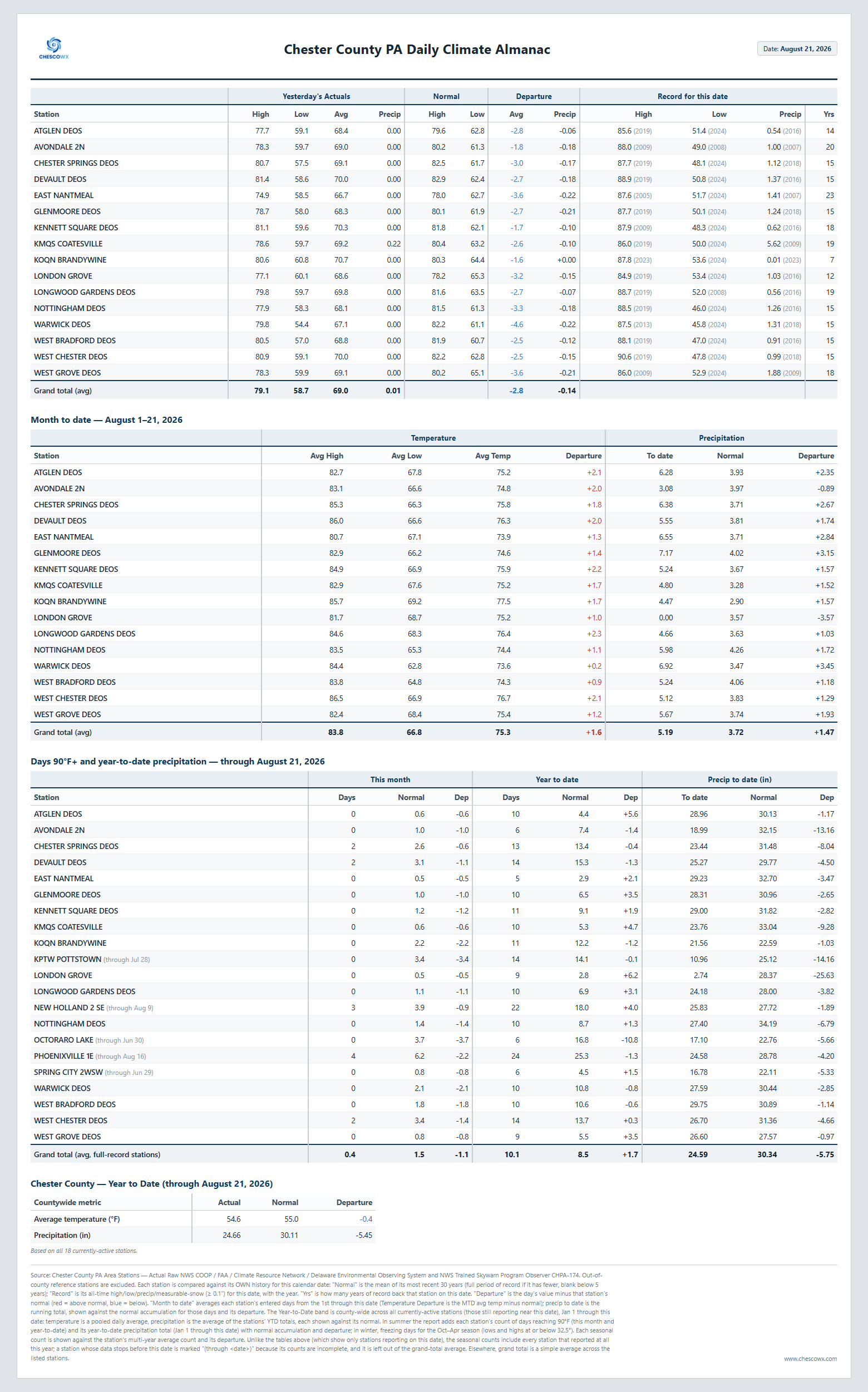
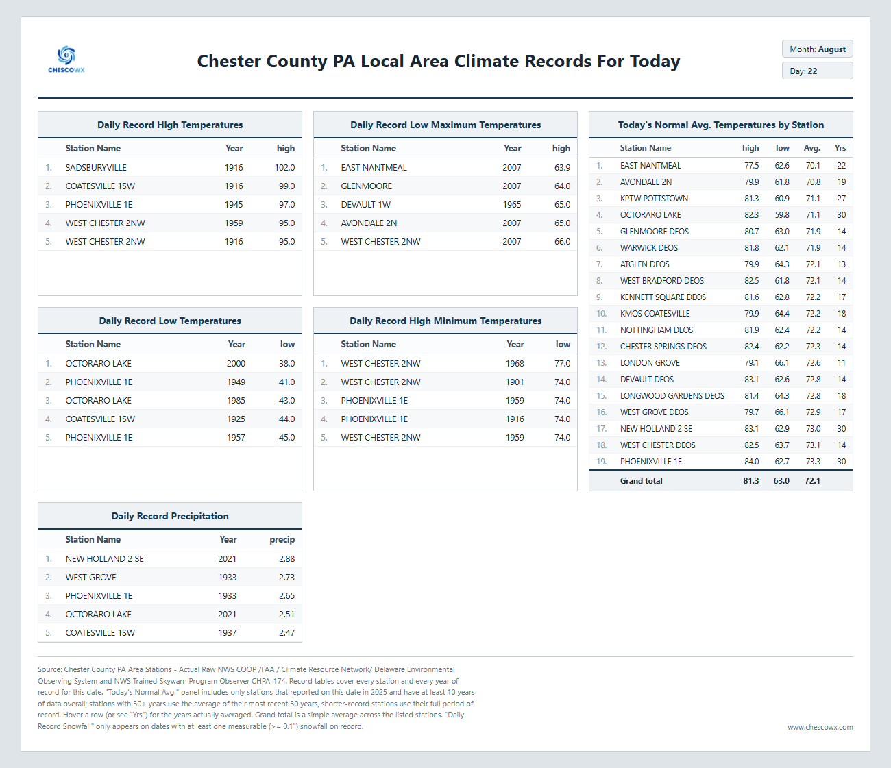
A bit more humid today before a cold front crosses the area late tonight which could spark some showers but will then usher in some beautiful weather through at least mid-week with below normal highs in the mid to upper 70's and lows in the 50's.
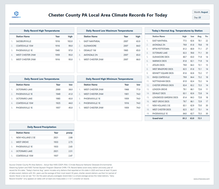
-
Aug dep through the first 3 weeks (21st) JFK: +2.1 ISP: +2.1 EWR: +1.8 LGA: +1.1 NYC: +0.3
-
Records: Highs: EWR: 94 (1983) what a difference a year makes NYC: 95 (1916) LGA: 93 (2019) JFK: 93 (1976) Lows: EWR: 51 (1982) NYC: 52 (1894) LGA: 55 (1982) JFK: 56 (1982) Historical: 1746: Salem, MA had a cold night, with "some frost so as to kill corn leaves" (Diary of Lt. John Preston ) 1816 - The growing season for corn was cut short as damaging frosts were reported from North Carolina to interior New England. (David Ludlum) 1821: A tornado ripped through Tybee Island, GA destroying a wing of the U.S. Army barracks. (Ref. Wilson Wx. History) 1851: A tornado ripped through Middlesex County in Massachusetts and injured 6 people. The tornado swept through Waltham, Belmont, West Cambridge, Arlington, and Medford. Six people died along with extensive damage. (Ref. NOAA Boston Weather Events) 1857: A tornado tore through Woodland, WI. Windstorm at Woodland, WI. Freight cars reportedly blown off railroad tracks. Although it leveled every building in the town, fortunately there were no deaths. (Ref. AccWeather Weather History) 1923 - The temperature at Anchorage, AK, reached 82 degrees, a record for August for the location which was later tied on the 2nd in 1978. (The Weather Channel) 1933: The Hampton Roads area of Virginia was hit on the night of the 22nd-23rd by its worst hurricane in history. Norfolk saw an 8 foot storm surge pushed through the streets of the city. Winds reached nearly 100 mph. 18 people were killed. (Ref. AccWeather Weather History) 1976: Heavy coastal rain 7.39 inches at Pocomoke City, VA but only a trace of rain in Washington, DC. 1980: Major flash flooding occurred in Kentucky as up to 3 inches of rain fell in a very short period. Heavy damage included flooded homes and washed out bridges and roads. Wichita Falls, TX reached 108° to establish a record for the date. 56 of the previous 59 days in Wichita Falls had reached a high temperature of 100 degrees or hotter. (Ref. AccWeather Weather History) New Orleans, LA hit 102° to establish their all-time record high temperature at the time. The new record is now 103 °F which occurred on August 30, 2000. (Extreme Weather p. 274, by Christopher C. Burt) 1985: Intense thunderstorms moved from near Shadehill Reservoir in northwest South Dakota late in the evening on the 21st, to northern Brown County after sunrise on this date. These thunderstorms produced strong winds, large hail, heavy rainfall and lightning. The strongest wind gust was reported in Hoven with a peak gust of 72 mph. Nine miles south and four miles west of Keldron, over two inches in diameter hail fell for 40 minutes, breaking windows and piling in ditches to a depth of four feet. These intense thunderstorms also produced brief heavy rainfall ranging from three quarters of an inch to over four inches. (Ref. Wilson Wx. History) 1987 - A cold front lowered temperatures 20 to 40 degrees across the north central U.S., and produced severe thunderstorms in Ohio and Lower Michigan. An early morning thunderstorm near Sydney MI produced high winds which spun a car around 180 degrees. (The National Weather Summary) (Storm Data) 1988 - Afternoon highs of 88 degrees at Astoria, OR, and 104 degrees at Medford, OR, were records for the date, and the number of daily record highs across the nation since the first of June topped the 2000 mark. (The National Weather Summary) 1989 - Evening thunderstorms in the central U.S. produced golf ball size hail at May City IA, and wind gusts to 66 mph at Balltown IA. Lightning struck a barn in Fayette County IA killing 750 hogs. Evening thunderstorms in Montana produced wind gusts to 70 mph at Havre. (The National Weather Summary) (Storm Data) 1992 - Hurricane Andrew makes landfall in Southern Florida as a Category 5 storm with wind guests estimated in excess of 175 m.p.h. Estimated damages exceeded $20 billion, more than 60 people were killed and approximately 2 million people were evacuated from their homes. (University of Illinois WW2010) 1994: Hurricane John, about 345 miles south of Hilo, Hawaii had winds of 175 mph and pressure at 920 millibars or 27.17 inches of mercury, making it one of the strongest hurricanes ever in the Central Pacific. The 31-day existence made John the longest-lasting tropical cyclone recorded in both the Pacific Ocean and worldwide, surpassing both Hurricane Tina's previous record in the Pacific of 24 days in the 1992 season and the 1899 San Ciriaco hurricane's previous world record of 28 days in the 1899 Atlantic season. John was also the farthest-traveling tropical cyclone in both Pacific Ocean and worldwide, with distance traveled of 7,165 miles, out-distancing previous record holders Hurricane Fico in the Pacific of 4,700 miles in the 1978 season and Hurricane Faith worldwide of 6,850 miles in the 1966 Atlantic season. 1998: Tropical Storm Charley was the second of 7 named tropical systems to strike the U.S. in 1998. But the most interesting event of Charley's arrival on the mainland would occur the next day, when 17.03 inches of rain fell in Del Rio, TX. This amount is nearly equal to the average rainfall for an entire year. It would establish their all-time record rainfall. 20 people died in flash flooding. (Ref. AccWeather Weather History) 1999: Tropical Storm Charley was the second of 7 named tropical systems to strike the U.S. in 1998. But the most interesting event of Charley's arrival on the mainland would occur the next day, when 17.03 inches of rain fell in Del Rio, TX. This amount is nearly equal to the average rainfall for an entire year. It would establish their all-time record rainfall. 20 people died in flash flooding. (Ref. Wilson Wx. History) 2002: Dubuque, Iowa: The Dubuque airport reports 8.96 inches of rain in a 24-hour period, setting a new record for the most rain in 24 hours. (Ref. WxDoctor)Described as a “blizzard” by town residents (and turning the ground white), a hailstorm battered Newman Grove, NE. Hailstones to tennis ball size were blown by 50-mph winds. 60-80% of the town’s homes were damaged; some had a dozen windows broken. (Weather Guide Calendar with Phenomenal Weather Events 2011 Accord Pub. 2010, USA) 2008: Severe thunderstorms produced large hail and strong winds over parts of eastern Wyoming and the Nebraska panhandle. A wind gust to 71 mph was recorded at the Chadron airport in Nebraska while 60 to 70 mph winds and hail up to 2 inches in diameter were reported around Douglas, WY.(Ref. Wilson Wx. History)
-
E PA/NJ/DE Summer 2026 Obs/Discussion
ChescoWx replied to PhiEaglesfan712's topic in Philadelphia Region
A bit more humid today before a cold front crosses the area late tonight which could spark some showers but will then usher in some beautiful weather through at least mid-week with below normal highs in the mid to upper 70's and lows in the 50's.
-
72 / 66 clouds and some breaks in the clouds in to nw nj. Hope to see some more clearing today which looks mainly dry. Chance of scattered showers / rain Sunday and then late clearing and a bit of a dryish but cloudy cooler weekend. Trough into the northeast through much of the nect days near / below normal before moderating 8/27 with more southerly humid / warm flow 8/28 - beyond. Atlantic ridge pushing towards the coast and inland heights rising so a much warmer overall beyond the 31st and looking throuugh labor day. 8/22 - 8/27 : Near / below normal 8/28 - 9/1 : moderating near / above normal humid perhaps wetter 9/2 - beyond : Warmer - much warmer (late season 90s possible)
-
Maybe we get some sun later based on the visible in the Eastern areas, after that multiple nice days with low dew points.
-
Some of us fail in every scenario.
-
Please. This has been going on for years. There is a reason why people say “The weatherman is the only job where you can be wrong and still keep your job”. Everyone looks at weather models too much and think they are the absolute outcome. how many hurricanes were predicted this year in the Atlantic. You going to blame that on government cuts too?
-

Augdewst 2026: Summer's Last Stand
VivaManchVegas replied to Prismshine Productions's topic in New England
It appears your neighbors are growing weed...