All Activity
- Past hour
-
Ha, dummy bet. Yet watch there be a BARREN basin of nothing 9/15-10/5 , beyond these posts
-
You're going away for 10 weeks? Sounds very intriguing.
-
Just kidding... I would be very surprised if we didn't see an uptick heading in late month period. We've got no where to go but up? Lol
-
Also; the main tropical thread was cleaned up some, much more readable now.
-

September 2025 OBS-Discussion centered NYC subforum
SACRUS replied to wdrag's topic in New York City Metro
Highs: PHL: 84 EWR: 81 New Brnswck: 80 TEB: 80 TTN: 80 ACY: 80 ISP: 79 * missing intra hour highs 1Pm - 7Pm LGA: 79 JFK: 78 NYC: 78 -
For here? pretty much never, so we are (well, I'm) not discussing that. For the overall tropical Atlantic? Things will heat up a bit. Though I'm skeptical outside of GOM at this point, until there is a legitimate contender.
-
A whole generation is growing up not knowing what a noreaster even is. The horror!
-
If "gone wild" means continuing the theme of almost no chance of tropical threat, then I agree!
- Yesterday
-

2025-2026 ENSO
PhiEaglesfan712 replied to 40/70 Benchmark's topic in Weather Forecasting and Discussion
For PHL, last 6-inch snowstorm was Jan 28-29, 2022. Last 8-inch snowstorm was Jan 22-23, 2016. The 2016 one was probably the last real KU for our area. -
18z gfs gone wild
-
Gfs is interesting
-

Occasional Thoughts on Climate Change
donsutherland1 replied to donsutherland1's topic in Climate Change
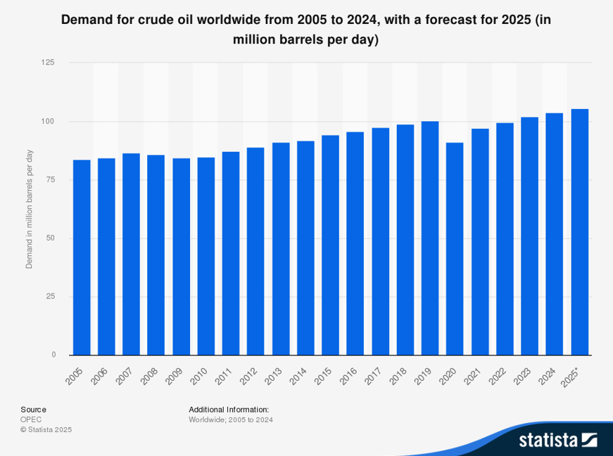
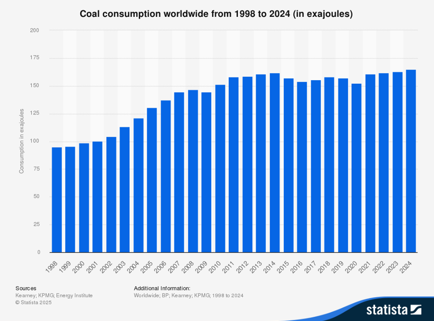
The problem is that oil, gas and coal consumption continues to increase, alongside renewables. This persistent growth locks in higher greenhouse gas emissions, undermining climate targets and amplifying extreme weather, sea-level rise, and ecosystem risks. Science has been clear. Scientists have done their job. Human society, at least its political leaders, have decided to continue burn excessive amounts of coal, gas, and oil despite the known consequences of their choice. From Statista: From the IEA: Global coal demand increased to a new all-time high in 2024 of around 8.8 billion tonnes, up 1.5% from 2023, as rising consumption in China, India, Indonesia and other emerging economies more than offset declines in advanced economies in Europe, North America and northeast Asia. However, several of those trends reversed in the first half of 2025 as demand declined in China and India; by contrast, coal use grew by around 10% in the United States. Even so, global coal demand is still set to increase slightly in 2025, followed by a marginal decline in 2026, bringing demand to just below 2024 levels.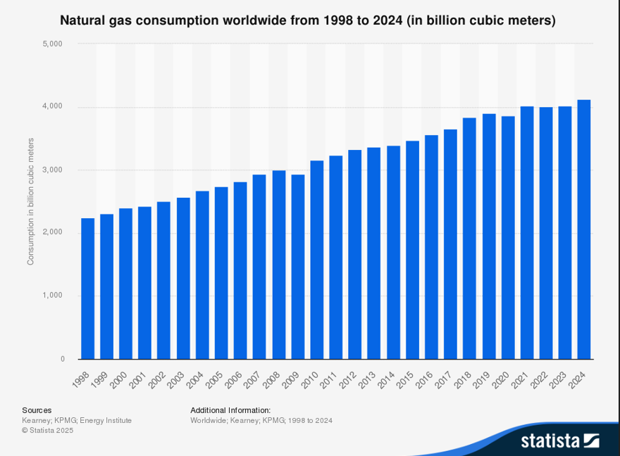
-
Picked up .02" yesterday and .01" at 4:20 am today. High of 81 after a low of 64. Felt nice out there with the lower humidity.
-

2025 Lawns & Gardens Thread. Making Lawns Great Again
rclab replied to Damage In Tolland's topic in New England
About seven years ago I had to have an oak removed from the postage stamp. I left the stump figuring it would be interesting to see which would disappear first me or it. This warm season the stump has been covered by an interesting absorbing fungi. When fresh it’s soft to the touch, then seems to harden. If it separates completely from the stump it becomes rock hard and darkens. Creatures, land and sky, including insects seem to avoid it. as always …..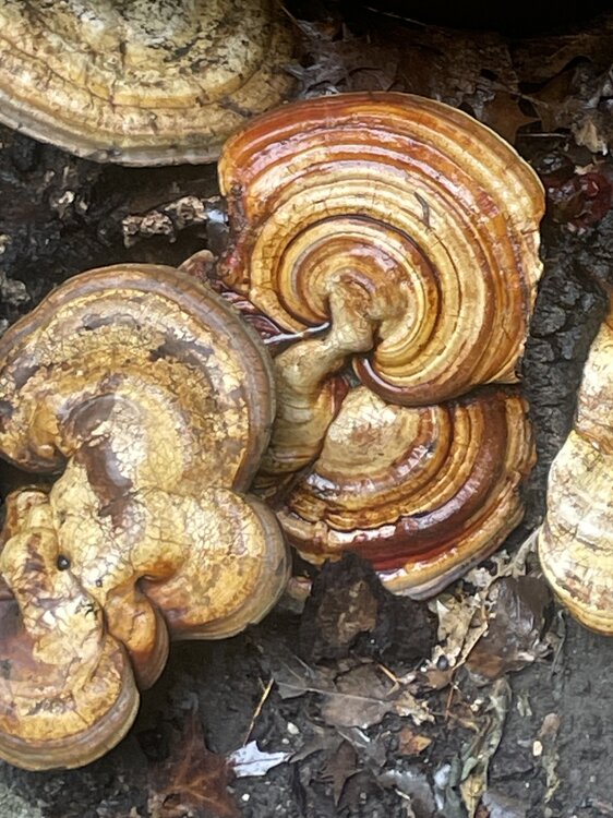


-
 2010 really spoiled me
 -
September 2025 OBS-Discussion centered NYC subforum
LibertyBell replied to wdrag's topic in New York City Metro
Was that the July 4th when we had really blue skies? My favorite. -
It means you guys are gonna get five straight Benchmark Blizzards along with a winter to remember.
-
September 2025 OBS-Discussion centered NYC subforum
LibertyBell replied to wdrag's topic in New York City Metro
The Poconos definitely got into the 30s, do you have a low temp for MPO Chris? -
Forget us grown snow weenies, let it happen for the kids! 10 years since our last legitimate snowstorm. That means there are tons of youngsters born around here that have never even experienced a real snowstorm. Shame!
-
September 2025 OBS-Discussion centered NYC subforum
LibertyBell replied to wdrag's topic in New York City Metro
those usual warm spots are way hotter than the rest of us, but I hold with my previous assertion, summer came to an end after mid August -
September 2025 OBS-Discussion centered NYC subforum
LibertyBell replied to wdrag's topic in New York City Metro
this dry weather is absolutely wonderful -
September 2025 OBS-Discussion centered NYC subforum
LibertyBell replied to wdrag's topic in New York City Metro
enjoy the dry stretch, we had more than enough rain last weekend why do people want rain so badly? -
September 2025 OBS-Discussion centered NYC subforum
LibertyBell replied to wdrag's topic in New York City Metro
As I said MANY weeks ago, summer basically came to an end after mid August. -
I liked that it didn't rain much (although it did rain last weekend.)
-
It's gonnabe a 2013-2014 Winter in the DC metropolitan region. Get the diggin shovels ready. Get ready to be watching models for months.