All Activity
- Past hour
-
Neither did I then!
-

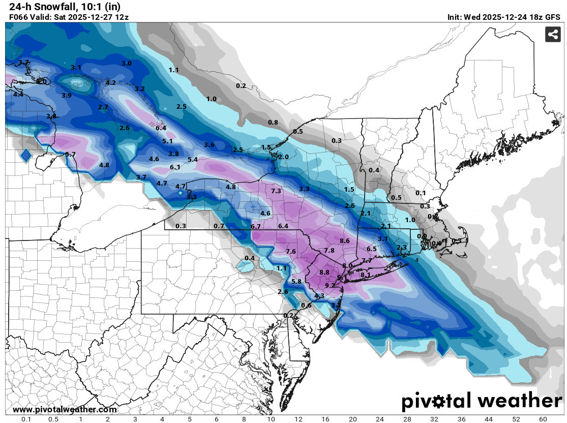
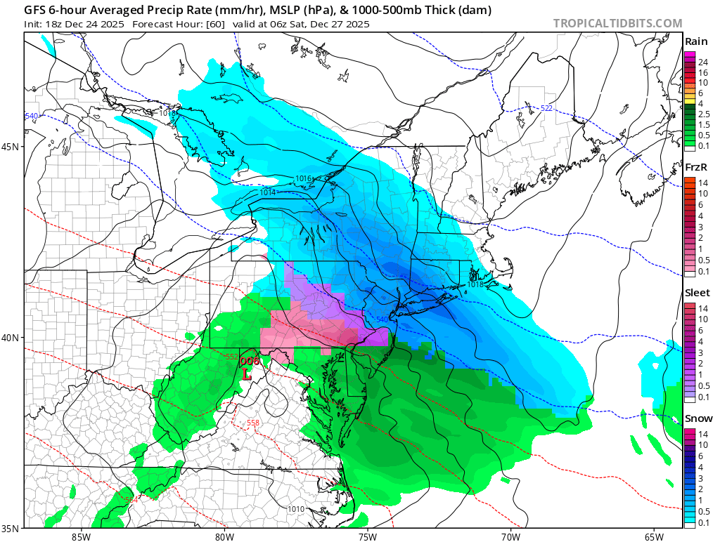
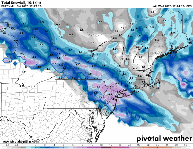
26th-27th event, coming at us like a wounded duck.
CoastalWx replied to Go Kart Mozart's topic in New England
Need a lot more help here but that’s nice to see. -

26th-27th event, coming at us like a wounded duck.
moneypitmike replied to Go Kart Mozart's topic in New England
Looks pretty good for CT folks. The only interest I have in the Friday system is if can somehow influence Sunday/Monday colder. Otherwise, I'll be cheering ya'll on. -

-

26th-27th event, coming at us like a wounded duck.
weatherwiz replied to Go Kart Mozart's topic in New England
Pretty hefty 3 hr bump for sure. probably some thunder in there too...a bit of a MAUL -

-
Man and just 5 days ago our science tools had DC near 70 Let’s face it. NOAA is No Different than any other government organization-seeking to preserve itself with actual outcome of services secondary at best Cover all bases and claim verification come crunch time .. One prominent poster here recently stated he has drastically changed his involvement with models . We all should and apply whatever pressures you can
-
Sign me up. No further north please
-
26th-27th event, coming at us like a wounded duck.
CoastalWx replied to Go Kart Mozart's topic in New England
That’s a nice bump -
-
6-10 according to GFS
-

26th-27th event, coming at us like a wounded duck.
Sey-Mour Snow replied to Go Kart Mozart's topic in New England
Forget nam’d we just got 18z gfs’d -
Useless without pics.
-

Central PA Winter 25/26 Discussion and Obs
canderson replied to MAG5035's topic in Upstate New York/Pennsylvania
Similar to HBG: Friday A slight chance of snow and sleet between 10am and 1pm, then snow, freezing rain, and sleet. High near 32. Light and variable wind becoming southeast 5 to 8 mph in the afternoon. Chance of precipitation is 100%. New snow and sleet accumulation of less than one inch possible. Friday Night Freezing rain and sleet, possibly mixed with snow before 10pm, then freezing rain and sleet between 10pm and 4am, then a chance of freezing rain after 4am. Low around 27. Southeast wind around 6 mph. Chance of precipitation is 100%. New snow and sleet accumulation of less than a half inch possible. Saturday A slight chance of snow and freezing rain before 1pm. Cloudy, with a high near 35. Chance of precipitation is 20%. -
Looks a hair north of 12z
-
26th-27th event, coming at us like a wounded duck.
Sey-Mour Snow replied to Go Kart Mozart's topic in New England
GFS! -
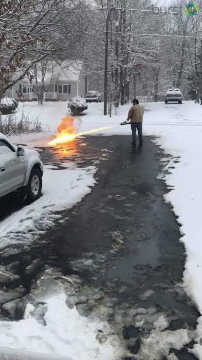
Here's an old beer commercial and my favorite
-
Gfs is going to show a big hit for NYC.
-

Central PA Winter 25/26 Discussion and Obs
WmsptWx replied to MAG5035's topic in Upstate New York/Pennsylvania
Friday Freezing rain and sleet, mainly after 1pm. High near 34. Calm wind becoming southeast around 6 mph in the afternoon. Chance of precipitation is 100%. New sleet accumulation of less than a half inch possible. Friday Night Freezing rain, possibly mixed with sleet before 4am, then a chance of sleet. Low around 26. Southeast wind around 5 mph becoming calm in the evening. Chance of precipitation is 100%. New sleet accumulation of less than a half inch possible. Saturday A chance of sleet, possibly mixing with freezing rain after 7am, then gradually ending. Cloudy, with a high near 38. Chance of precipitation is 30%. New precipitation amounts of less than a tenth of an inch possible. -
I'll take Jan 2011 for the win please...
-
The thing is, similarly extreme patterns have happened in the past. Look at 1917 or 1933. Crazy warmth in some areas, crazy cold others. Main difference now is everything is a degree or two warmer - but 90% of it is driven by the pattern, which I don't believe is driven by AGW.
-
High here of 32.7F was just after midnight, we've been at/below freezing since 12:30 am. While not postcard quality outside, its still nice to see snow covered ground. Its making my Christmas just a bit merrier to see my yard decorations sitting in snow vs the green stuff! Plenty of other days on my calendar for that. Hope everyone can have a Merry Christmas whatever your wx.
-
....or what a crap storm.
-
We're going to need to build an aquaduct from one of the Great Lakes.
-

White Christmas Miracle? December 23-24th
powderfreak replied to Baroclinic Zone's topic in New England
Making sure not to have a White Xmas…