All Activity
- Past hour
-
Records: Highs: EWR: 61 (2002) NYC: 60 (2002) LGA: 61 (1957) JFK: 57 (1999) Lows: EWR: -1 (1942) *earliest sub zero reading at Newark on record NYC: -4 (1942) LGA: -2 (1942) JFK: 12 (2004) Historical: 1836 - A famous cold wave occurred in central Illinois. A cold front with 70 mph winds swept through at Noon dropping the temperature from 40 degrees to near zero in a matter of minutes. Many settlers froze to death. Folklore told of chickens frozen in their tracks and men frozen to saddles. Ice in streams reportedly froze to six inches in a few hours. (David Ludlum) (The Weather Channel) 1929: An exceptional storm produced snow from the Middle Rio Grande Valley of Texas to southern Arkansas on December 20 - 21st, 1929. The storm produced 26 inches of snow near Hillsboro, Texas, and 24 inches in 24 hours in Clifton. 1942 - An early cold wave sent the temperature plunging to 3 degrees below zero at Nantucket, MA, and to 11 degrees below zero at Boston MA. (The Weather Channel) 1977: A "Once in a Lifetime" wind and dust storm struck the south end of the San Joaquin Valley in California. Winds reached 88 mph at Arvin before the anemometer broke, and gusts were estimated at 192 mph at Arvin by a U.S. Geological Survey. Meadows Field in Bakersfield recorded sustained 46 mph winds with a gust of 63 mph. The strong winds generated a wall of dust resembling a tidal wave that was 5,000 feet high over Arvin. Blowing sand stripped painted surfaces to bare metal and trapped people in vehicles for several hours. 70% of homes received structural damage in Arvin, Edison, and East Bakersfield. 120,000 Kern County customers lost power. Agriculture was impacted as 25 million tons of soil was loosened from grazing lands. Five people died, and damages totaled $34 million. These strong winds also spread a large fire through the Honda Canyon on Vandenberg Air Force Base in southern California. This fire, which started from a power pole on Tranquillon Ridge being blown over, claimed the lives of Base Commander Colonel Joseph Turner, Fire Chief Billy Bell, and Assistant Fire Chief Eugene Cooper. Additionally, severe burns were experienced by Heavy Equipment Operator Clarence McCauley. He later died due to complications from the burns. 1983: An extreme bitterly cold air mass continued across much of the U.S. The temperature remained below zero at Denver, CO for 115 consecutive hours; their longest sub-zero period on record. Locations reporting record low temperatures for the date included: International Falls, MN: -40 °F, Bozeman, MT: -36 °F, St. Cloud, MN: -35 °F, Duluth, MN: -34 °F, Casper, WY: -32 °F, Marquette, MI: -28 °F, Rochester, MN: -26 °F, Great Falls, MT: -25 °F, Cheyenne, WY: -25 °F, La Crosse, WI: -24 °F, Scottsbluff, NE: -23 °F: Tied, Waterloo, IA: -20 °F, Rapid City. (Ref. Wilson - Additional Temperatures Listed On This Link) 1984: Lili, a rare December hurricane, was officially declared a tropical system in the central Atlantic as a distinct eye type feature was apparent on satellite imagery. The hurricane peaked at sustained 80 mph winds and a pressure of 980 millibars or 28.94 inches of mercury, a very respectable Category 1 Hurricane in December. 1986: An "Alberta Clipper" developed explosively just south of New England and blasted the region with high winds, torrential rain, and heavy snow. Up to 4 inches of rain fell across southern New England and winds frequently gusted to 60 and 70 mph. 30 inches of snow fell in southern Vermont, 24 inches in the higher elevations of western Massachusetts, and 20 inches in parts of New Hampshire. (Ref. Wilson Wx. History) 1987 - Heavy snow fell in the northern mountains of Colorado, with 15 inches reported in the Mary Jane ski area. Strong and gusty winds prevailed from the Northern High Plains to the Great Lakes. Winds gusted to 54 mph at Buffalo NY, and reached 66 mph at Livingston MT. Rain, freezing rain, sleet and snow fell across New England, with up to seven inches of snow in Maine. (The National Weather Summary) (Storm Data) 1988 - Strong southerly winds ahead of a cold front in the central U.S. gusted to 70 mph at Indianapolis IN. The high winds toppled a masonary wall killing a construction worker. Low pressure and a trailing cold front brought rain and snow and high winds to the western U.S. Winds gusted to 90 mph at the Callahan Ranch south of Reno NV. Soda Springs, in the Sierra Nevada Range of California, received 17 inches of snow in less than 24 hours. (Storm Data) (The National Weather Summary) 1989 - Brutal northwest winds ushered bitter cold arctic air into the north central U.S. International Falls, MN, and Warroad, MN, tied for honors as the cold spot in the nation with morning lows of 34 degrees below zero. Minot ND reported a wind chill reading of 81 degrees below zero. Squalls produced more heavy snow in the Great Lakes Region. Erie PA received 21 inches of snow, including four inches in one hour, to bring their total snow cover to 39 inches, an all-time record for that location. (Storm Data) (The National Weather Summary) 2006 - A major winter storm affected Colorado, dumping several feet of snow on areas of the Rocky Mountains. The snowstorm temporarily closed the Denver International Airport.
-

White Christmas Miracle? December 23-24th
CoastalWx replied to Baroclinic Zone's topic in New England
6z moved to a more widespread look. -
The fact we avoided this last winter is impressive
-

Possible Light Snowfall (1" - 4") on Tuesday Dec 23
Northof78 replied to Northof78's topic in New York City Metro
Not sure the surface will be a problem generally, but for city itself heat island always an issue unless really cold. -
28 / 15 - 1.34 in the bucket - buckets , chairs , christmas decorations everywhere from 48- 52 MPH gusts here, higher elsewhere. Cold today, warmer Sunday (low 40s), colder Mon / Tue with some light rain/mix/snow showers Tuesday. Christmas eve through new years eve is overall warm with a day or two colder in between as massive ridge is positioned in the nations midsection with the warmest to our south and west and very cold north east. Still would watch for a storm in the 30/31st period. Beyond there near normal / slightly below. Rain focuses into the west with copious moisture aimed at the WC/California.
-

White Christmas Miracle? December 23-24th
WinterWolf replied to Baroclinic Zone's topic in New England
6z moved to a LBSW, or toward the better look? -
Same here. I don't expect snowy Christmases (or Decembers in general) in the DMV area anyhow. But a nice, chilly day in the 40s or so is fine, and at least not a washout with rain. Or where it feels humid as you say! In 2015 here, we had that ridiculous +8 or so departure for the month (thank God that didn't happen in July!). It was literally uncomfortably warm and humid after some heavy rain late evening on Christmas Eve. Now, growing up in northeast Ohio, different story! Definitely plenty of cold and snowy Decembers and Christmases there which was always great. Actually I recall one of the most striking reversals in terms of Christmas temperatures. In 1982, Cleveland set a record high on Christmas of 66 degrees (that was a crap winter all around). Exactly one year later in 1983, they set a record low of -10, brutal cold and wind all day with some Lake effect snow, temperatures barely got into the single digits for highs.
-
White Christmas Miracle? December 23-24th
CoastalWx replied to Baroclinic Zone's topic in New England
I would like to see continued improvement on guidance and not a LBSW thing today. 6z moved towards it. -

White Christmas Miracle? December 23-24th
Ginx snewx replied to Baroclinic Zone's topic in New England
I remember when people complained about the Juju word back on Eastern. Lol There was no Grinch storm instead its a Christmas miracle. Festivus for the rest of us. -

December 2025 Short/Medium Range Forecast Thread
Holston_River_Rambler replied to John1122's topic in Tennessee Valley
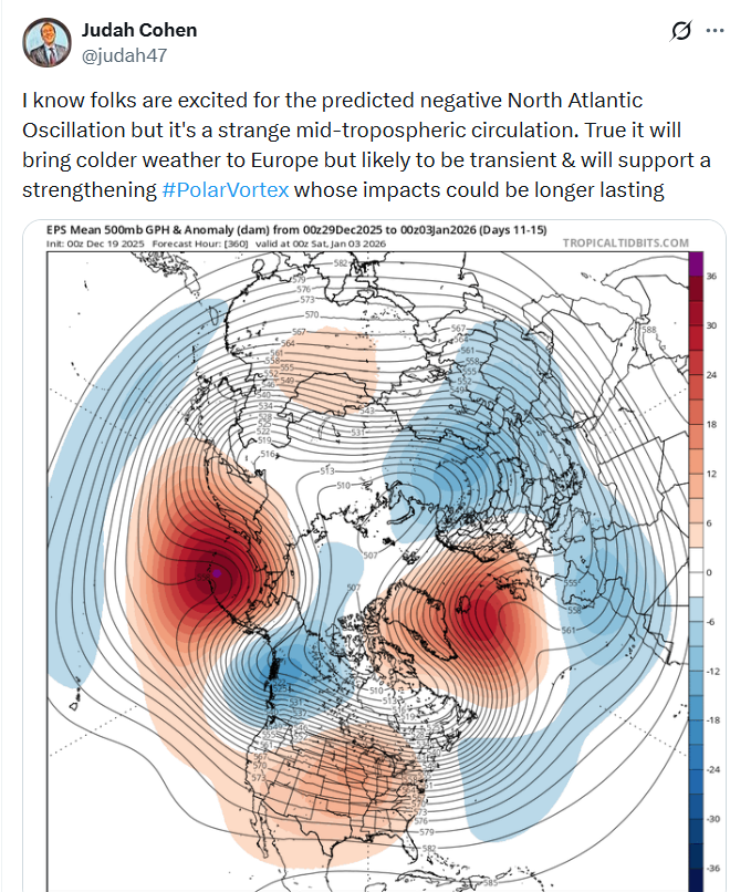
Wonder which PV he's talking about in the above? Stratospheric or tropospheric? #PolarVortex doesn't make it clear. It's almost as if he's looking for clicks or something. A strengthening -NAO can put pressure on the SPV and the TPV. Example from 0z Euro: I chose 30mb because that pressure level is lower and closer to where the potential -NAO is forming. The same processes that are helping to create the -NAO on the recent deterministic runs are also fluxing heat poleward at the tropopause. 500mb: Tropopause: Pac jet doesn't look terrible to me in deterministic progs. Right now, yeah, that's not good: We never really want to see it all the way across the Pac. But going forward, looks buckly to me. Of course that and anything can and will change. I'm encouraged this AM by the OPs finding the -NAO again and that wavy pac jet look. I seen years where that jet was just a fire hose all the way across the Pac in to California. -
Great composition and depth of field!
-
Yeah I just took a look at the guidance and consensus is growing on a nice 2-4” event. And since it will be cold enough afterwards, that means we’d get a White Christmas.
-
White Christmas Miracle? December 23-24th
WinterWolf replied to Baroclinic Zone's topic in New England
You have “If bringing my juju back”…I think you mean “I’m” bringing my juju back…right? Correct that so the snow gods don’t punish us for poor grammar..please -
"the year"? As in it only happened once?
-
White Christmas Miracle? December 23-24th
Ginx snewx replied to Baroclinic Zone's topic in New England
Its beginning to look alot like Christmas Congrats Jeffafafafa to Dendrite and everyone else.png.8bcb600df88e49684f2249371adf635e.png)
.png.1235c6ce0f668ad356c83f6bfd431057.png)
-

Central PA Winter 25/26 Discussion and Obs
Mount Joy Snowman replied to MAG5035's topic in Upstate New York/Pennsylvania
Low of 23. Total rainfall was .54”. Have to host a big family gathering today. Lots of work to do this morning. Enjoy the weekend everyone! -
Sweet look for here. GFS works too. Just like the troughs I used to know.
-

December 2025 regional war/obs/disco thread
Baroclinic Zone replied to Torch Tiger's topic in New England
LFG! -
If bringing my juju back for this one. Let’s talk about the shortwave traversing across the northern tier states and crossing the area on the 23rd. High pressure is overhead and we have a fresh antecedent airmass cold enough to support frozen precip. High pressure pushes south and we get that moist southerly return air just as system is moving in. Potential is there for advisory level snows for a broad area. Also seeing some potential for redevelopment or inverted trough as system pushes offshore.
-

December 2025 regional war/obs/disco thread
SouthCoastMA replied to Torch Tiger's topic in New England
clips the ema coast Christmas eve morning. It sort of looks like the trough on 12/14, but more pronounced. something to watch at least -

Central PA Winter 25/26 Discussion and Obs
pawatch replied to MAG5035's topic in Upstate New York/Pennsylvania
My power went out 3 times, but was back on within 5 minutes. Some other people were less fortunate. We had 53 mph wind gust and a 1/4” of rain dumped on us in less than a couple minutes. Crazy weather. -
Do you still have anything on the ground up there? Surprisingly didn't loose everything here... but most, probably 20 percent coverage
-
Remember the year with lots of snow on the ground until the 23 and gone by xmas? That was the ultimate kick in the balls. Lots of ice on the roads 31F
- Today
-

December 2025 Short/Medium Range Forecast Thread
*Flash* replied to John1122's topic in Tennessee Valley
Curious...has our area ever done well with a strong PV before? Seems the -NAO may not be enough based on what JC is suggesting here...
-

Possible Light Snowfall (1" - 4") on Tuesday Dec 23
MJO812 replied to Northof78's topic in New York City Metro
I think the snow sticks on colder surfaces for the city unless the precip rushes in faster than modeled.