All Activity
- Past hour
-
77F. heat wave.
-
It is fall, no matter what the temps say for today I am eating some soup for lunch.
-
We had 107% of average rain April-June but only 66% for July-Sept. However, we had frosts on 23-24 and 8 other September mornings in the 30s. Whatever the reason, the colors have been spectacular. Currently I'm watching sugar maple leaves raining past the window, despite nearly calm wind and 60s, so we'll soon be past peak. The morning low of 60 here is 20° AN, and yesterday's 73 was only one degree below the warmest we had last month. Clouds still look thick, so I don't think we'll get much past 70, if any at all.
-
I know it is hard to accept because of Fay’s tenacity, but the 0Z UKMET actually dropped her coming back to being a TC. Poor Fay
-
Right on schedule here along rt 2 ...this leg of it anyway. Color schemes are also species consistent without unusuals. This is the first 'climatological foliage' behaving year in some time...
-
81 out, kinda clear skues but hazey.
-

January 25-26 Winter Storm Potential
penndotguy replied to Ralph Wiggum's topic in Philadelphia Region
It was a pretty good winter for sure, Even though we missed out on the Biggie in February. would be nice to have a repeat this Winter -
Push that front south... I want to play some baseball
-
no winter
-
We always are ahead of most places in CT other than NW CT for foliage despite never being cold at night . I really think it’s mainly due to the cooler days than other areas. It’s about peak for maples this weekend . But Oaks mainly green with some yellows . We really two peak seasons here. One for other species and another for Oaks
-
Fixin to reverse jinx myself a 30"er
-
Sunday looking like diddly squat in terms of moisture. Potentially more tonight/tomorrow am? But looks hit and miss.
-
I have some lespedeza in the lawn near the house and prostrate knotweed growing in the driveway and the edges. I don’t mind some weeds, but those 2 I can do without. My little meadow area by the run has milky spurge growing in there too. Anyone ever use one of those propane weed torches? I’ve been thinking about cooking the affected areas next spring. I know it will kill everything, but I assume the grass will eventually grow back.
- Today
-
I’ve long thought if you wanted a poster child for warming, BTV is it. Before the new normals came out, it felt like every month started at +2 as a baseline. The place just doesn’t cool off at night anymore for the most part.
-
No disagreement ... it's a low probability return. sure. The tussle I meant to expand upon is that as this fledgling season is coming in, there is increasing modeled injects off the NE Pac of these -2 SD polar anomalies. They're rocketing along the interface of a vast southern geopotential positive anomaly. Whenever they do, that S/W moves from MT to NS in about a coffee break. Really fast. These -2 waves may in fact expose a suppressed -PDO type exertion - a sort of "non-linear"/invisible lingering -PDOness. heh. somethin like that... So early on, the conflict may be brewing. I hear you about 2023 but I thought of 2023 as not a real El Nino frankly. Yeah, it met the criteria of course in the traditional scope and scale. Of course. But even in a RONI reprocessing, RONI isn't perfect either... My thing is that the Earth system was still in the throws really of registering that giant spring burst in thermal recovery that took place. It superseded the ENSO onset - and was also ... ( I feel strongly ) wrongly attributed to being because of the onsetting El NINO... but it was the wrong epistemic direction. Because the former happened first! we can go around and around with that... but the point is, there were concurrent massive signals and it'll take a lot more necessary math and science in order to figure out what was really proxy on that ensuing winter. I think having a whole planet warm a half degree C (fun trivia: ~ equivalent to 250 times the yield of the world's nuclear arsenal detonated at once. If we include the jump in the ocean to that calculation, it's thousands of time greater, btw -) needs to unequivocally explained before believing the ENSO that year was proxy over something with enough energy to holocaust the planet 250 times over. I dunno, but now years on that warm burst is hypothetically, fully 'absorbed' and accounted for in the ongoing machinery of the ID CGT ( Intradecadal circum-global teleconnector)...yet, we are left with a -PDO suggestion that should not be there given this scope of ENSO. These are compelling concepts for me anyway- Or not.. could all turn out to be nothin. But in the balance... teetering one way or the other comes down to unbalanced forcing.
-
Cue all the pro twitter Mets: "This is a very complicated setup and we won't know how it's gonna end up until it ends up".
-
2026-2027 Fall/Winter Mountain Thread
Moonhowl replied to BlueRidgeFolklore's topic in Southeastern States
Please, please do not let this fizzle and dry up; rain dance time -
Another possibility I am toying with is having more of a supply of cold readily available to the CONUS relative to the east-based intense Nino composite AND having the STJ displaced N & W relative to said composite...which could be great for us, especially across the interior.
-
Yeah I'm an electrical engineer - primarily power systems and their controls.
-
It served it's purpose well. Reverse jinx.
-
I don’t remember if I posted BTV before, but I was going through some of the old climo links and found their old normals. Pretty drastic shift warmer there in the last 30 yrs. https://wrcc-archive.dri.edu/cgi-bin/cliNORMNCDC.pl?vt1081 https://wrcc-archive.dri.edu/cgi-bin/cliMAIN.pl?vt1081
-
I'm a bit torn on how the disconnect between the PDO and ENSO may go.....I see some indicate that it could force a colder outcome in the east, but that definitely didn't work out in 2023. I see how it could weaken the GOA low, thus reducing the proclivity for +EPO/strong Pac jet, but I also see that adding an element of destructive interference via elevated se heights....I tend to place greater emphasis on the latter, but perhaps we are especially prone to severe bouts of winter when said SE heights relative to expectation relax.
-
We had that one min in the upper 30s here…maybe 35-38 in the area depending on elevation. We’ve had a lot of Septembers with more 30s than that. Whatever it is, everything is lining up for a great season.
-

2026-2027 Record-breaking El Nino
GaWx replied to Stormchaserchuck1's topic in Weather Forecasting and Discussion
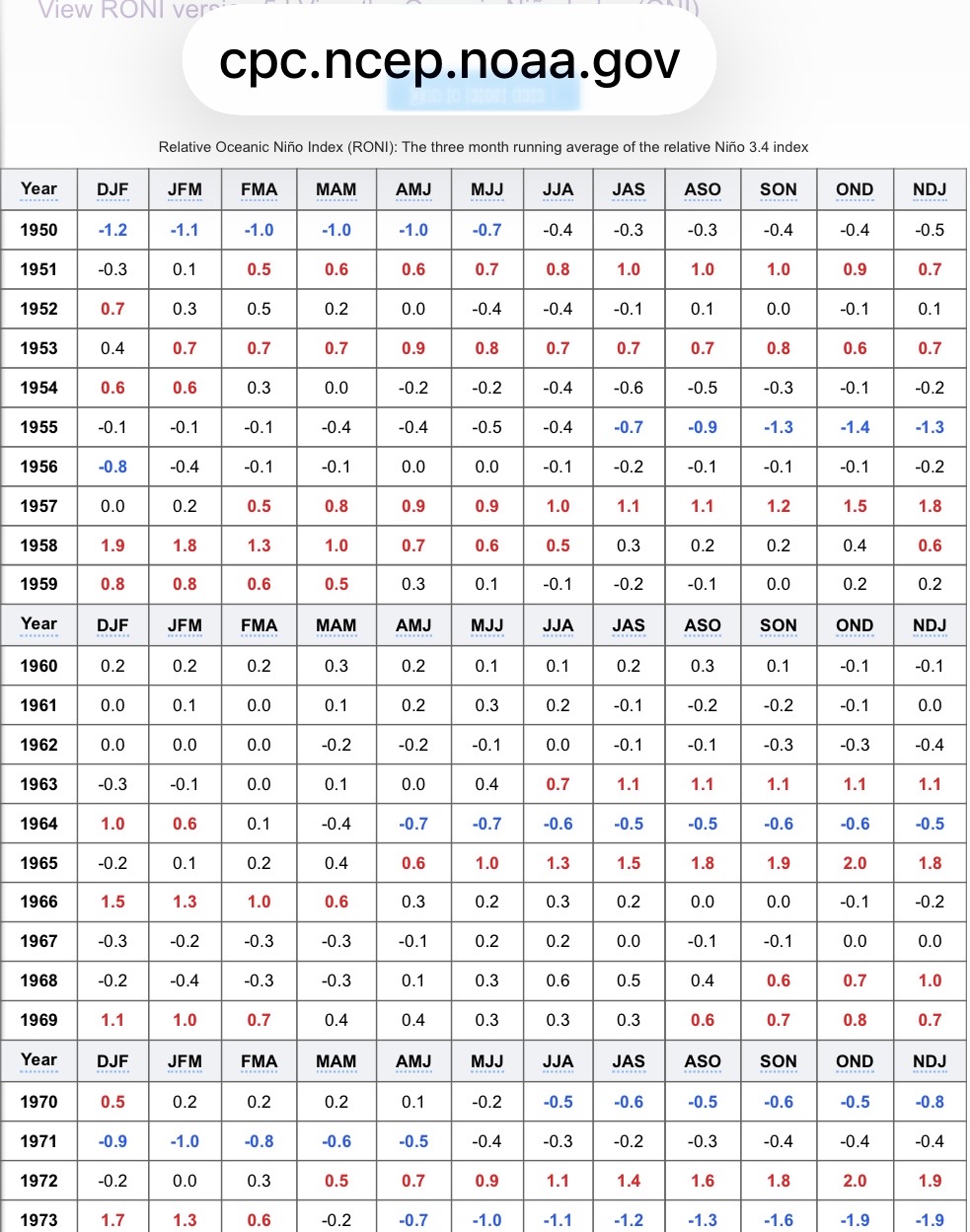
The CPC has 1972-3 peaking at +2.0 in its most up to date RONI table linked just below. Since RONI is the official way of classifying (and has been since Feb), that’s the current CPC official peak for 1972-3 rather than +1.8: https://www.cpc.ncep.noaa.gov/products/analysis_monitoring/enso/roni/ More on the transition of CPC from ONI to RONI for official classification of ENSO (this was released in Feb 2026): https://www.cpc.ncep.noaa.gov/products/analysis_monitoring/enso/roni/announcement.php From the link above: “The Climate Prediction Center is making the shift to use the Relative Oceanic Niño Index (RONI) to better designate past events and predict future ENSO.” ——————— The table at the link below, which is to the most up to date ONI, has 1972-3 peaking at +1.8. But ONI hasn’t been the official way for CPC to classify since Feb. At the top it says this: This page will continue to be updated by the 5th of each month, but per NWS Public Information Statement 26-05, the Relative Oceanic Niño index (RONI) is used for official monitoring and prediction of the El Niño-Southern Oscillation (ENSO) phenomenon. https://www.cpc.ncep.noaa.gov/products/analysis_monitoring/enso/oni/v6/ @Maestrobjwa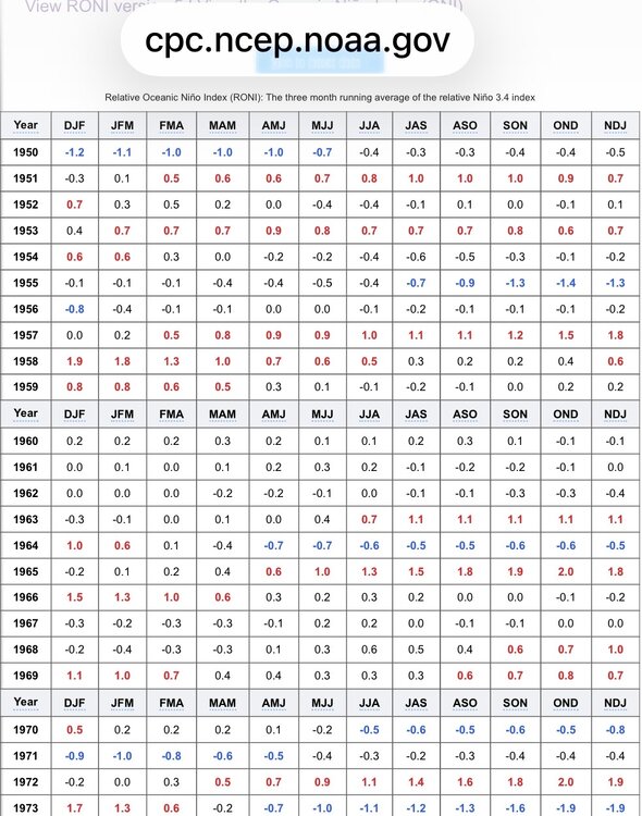
-

2026-2027 Record-breaking El Nino
mitchnick replied to Stormchaserchuck1's topic in Weather Forecasting and Discussion
The October "mother of all WWB" has been on the Cfs2 for close to 2 months. Hard to believe with that model, but true nonetheless.