All Activity
- Past hour
-
Another 10/10 early spring day
-
how does one prepare? is it like going to the store to buy milk and bread
-

-
(002).thumb.png.6e3d9d46bca5fe41aab7a74871dd8af8.png)
Central PA Spring 2026 Discussion/Obs Thread
ChescoWx replied to Voyager's topic in Upstate New York/Pennsylvania
Today will be our 7th consecutive below normal temperature day with our temperatures remaining below normal through this weekend before we warm to above normal by Tuesday. We then turn cooler again for the rest of the first week of May. Overall, the long-range models see a chillier than normal month with some models continuing the relative chill into June. We have some slight shower chances tonight with rain chances increasing toward the middle of next week.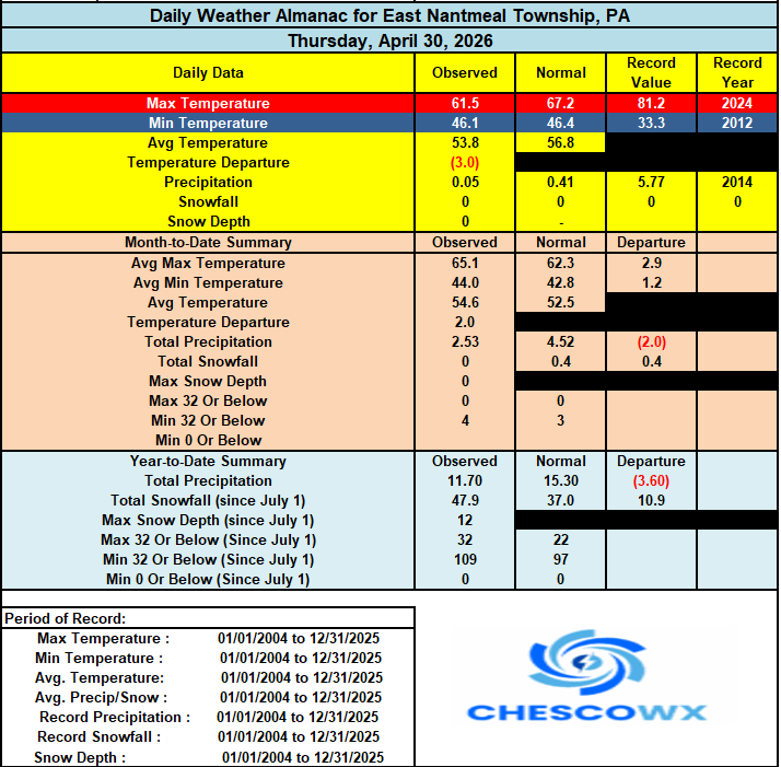

-

2026-2027 Strong El Nino
40/70 Benchmark replied to Stormchaserchuck1's topic in Weather Forecasting and Discussion
Yea, I mentioned that in my March recap...there is often a bonafide Pacific trough regime about 10 days following PV splits. Showed up in two of my primary analogs: This split of the PV was then followed by a strong Pacific trough regime that resulted in record warmth about 7-10 days later, which was in fact very comparable to the sequence observed in the wake of the February 2018 analog-warming. This is same phenomenon also occurred to a somewhat lesser extent in 2001, as very warm temperatures with highs in the 50s also occurred on February 20th, 2001, which is 10 days subsequent to the February 11th, 2001 PV split. -

Central PA Spring 2026 Discussion/Obs Thread
Mount Joy Snowman replied to Voyager's topic in Upstate New York/Pennsylvania
Low of 38 with .01” of rain. Beautiful cool spring day on tap. -
43 for the low in Alexandria, 32 out at McHenry.
-
E PA/NJ/DE Spring 2026 Obs/Discussion
ChescoWx replied to PhiEaglesfan712's topic in Philadelphia Region
Today will be our 7th consecutive below normal temperature day with our temperatures remaining below normal through this weekend before we warm to above normal by Tuesday. We then turn cooler again for the rest of the first week of May. Overall, the long-range models see a chillier than normal month with some models continuing the relative chill into June. We have some slight shower chances tonight with rain chances increasing toward the middle of next week.
-
It's here everyone
-
we prepare to start tracking convective threats.
-
2026-2027 Strong El Nino
40/70 Benchmark replied to Stormchaserchuck1's topic in Weather Forecasting and Discussion
Okay, this is what I focus on...the reversal, which is why 2023 didn't register with me. I know February 2023 had a reversal.....but wasn't under the impression that the 23-24 season did. -
 DCA: -1.3 NYC: -1.6 BOS: -1.8 ORD: -1.5 ATL: +1.0 IAH: +2.5 DEN: +3.5 PHX: +2.5 SEA: +3.0 for may
 -
You can see the the coastal SNE depression GWDLT NNE ftw

-
Low was 35.4 degrees, chilly but not a record (30 from 1996). No frost here, but lower elevation and down next to the river it is heavy!
-
2026-2027 Strong El Nino
40/70 Benchmark replied to Stormchaserchuck1's topic in Weather Forecasting and Discussion
1982-1983 is the only super El Nino that had kind of a favorable WPO, which is likely why the NE managed near normal snowfall. -
2026-2027 Strong El Nino
40/70 Benchmark replied to Stormchaserchuck1's topic in Weather Forecasting and Discussion
Snowman must have missed that part of the seasonal forecast in his tweet regurgitation. -
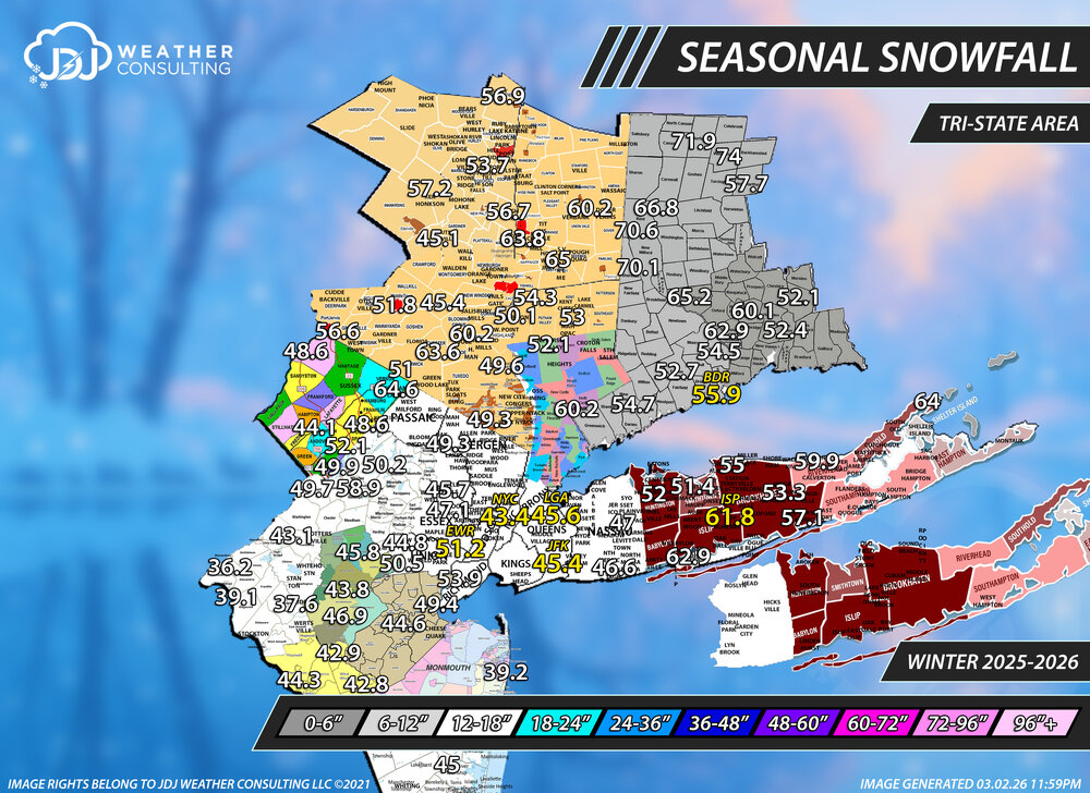
Last call for any final season snowfall reports for Tri-State Area (if you didn't already msg me). I'll have all the final season snowfall maps out this week. If i don't hear from you ill do my best to add the 3 minor events from Mar 3-4, Mar 5-6 and Apr 7 to this map. The numbers on this map were ending on March 2nd (except the climate sites which i already changed).
-
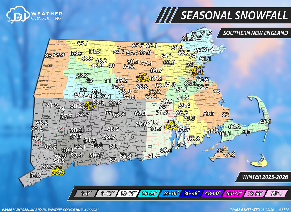
Last call for any final season snowfall reports for SNE (if you didn't already msg me). I'll have all the final season snowfall maps out this week. If i don't hear from you ill do my best to add the 3 minor events from Mar 3-4, Mar 5-6 and Apr 7 to this map. The numbers on this map were ending on March 2nd (except the climate sites which i already changed).
-
E PA/NJ/DE Spring 2026 Obs/Discussion
ChescoWx replied to PhiEaglesfan712's topic in Philadelphia Region
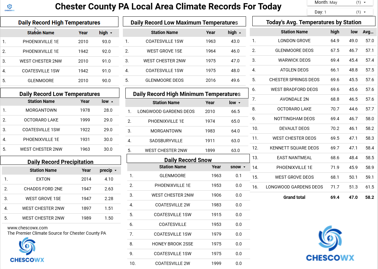
East Nantmeal finished with an April temperatures of 54.6 (+2.0 degrees above the 2003-2025 average) this is good for the 5th warmest April across 23 years of records. I am working up the overall Chester County climate records today and will share later. Overall with records back to 1893 we should come in close to a top 15 warmest April. -
the same nothing that happens every year on May 1
-

Occasional Thoughts on Climate Change
WolfStock1 replied to donsutherland1's topic in Climate Change
OK fair enough. I see there are factors that result in differences between the hemispheres, though 3 degrees C (about what's shown on that chart) just seems like a bigger range than one would expect as variation. It doesn't seem like the physics would be such that land-vs-water heating rates would be a factor - it should even out should it not? Yes the land heats faster than water, but it also cools faster at night. I could be wrong but I wouldn't think that the cause of heating faster during the day is due to higher level of actual heat absorption, but rather due to the higher level of thermal conductivity of the oceans (they absorb just as much heat - it just spreads out mostly across the depth vs remaining on the surface) Biggest factor though would probably be Antarctica reflecting the energy from the sun back to space. I see another factor is currents; one would think that factor would be minimal, as most currents don't cross the equator; though I know it's complex and there is some crossing. -
A nice cold morning out with a low of 40 degrees.
-
AI usually has animals portrayed with some ridiculous human theme.
-
You have a nice setting! We've just moved to a new construction home and there's no topsoil at all - just hard, gravelly sand. Gardening is gonna be tough! Having an April with almost a shutout of rainfall didn't help
-

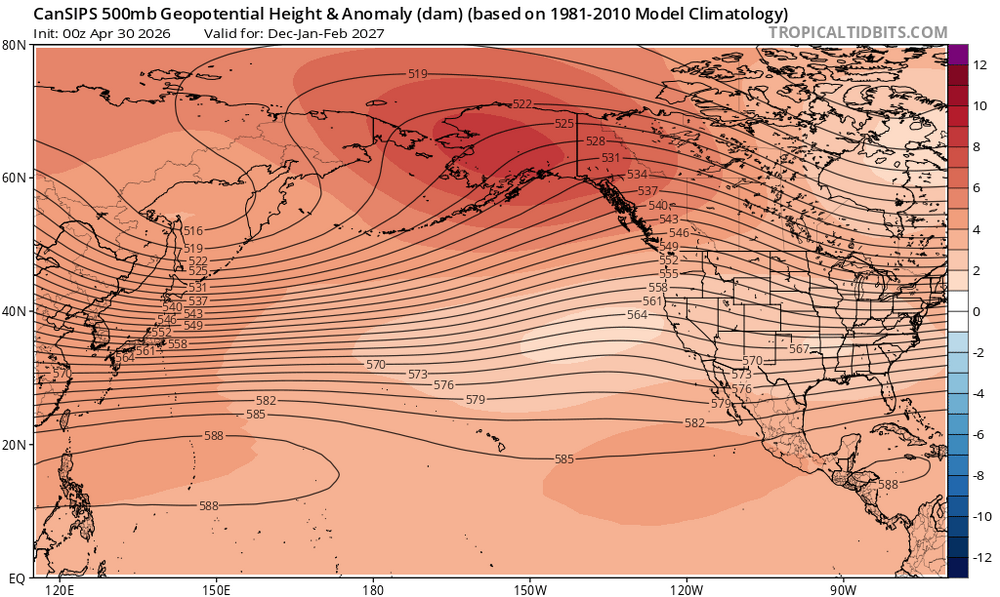
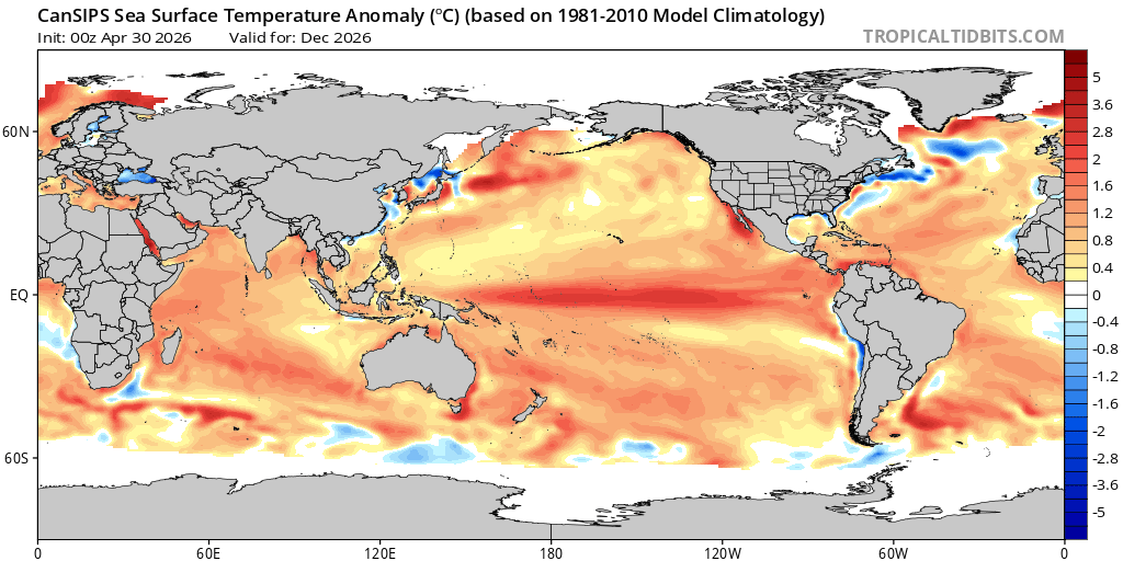
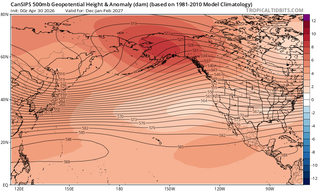
2026-2027 Strong El Nino
bluewave replied to Stormchaserchuck1's topic in Weather Forecasting and Discussion
Even though the Cansips now gets to +2.0 on the ONI, the RONI looks weaker. So the big warm pool east of Japan seems to be resulting in a record -WPO for such a strong El Nino. Notice how the Aleutian low is substantially weakened and is further south just off of California. I agree with you that we typically haven’t seen cool anomalies near the Great Lakes with such strong events in the past. Perhaps the warm pool east of Japan could lead to a weaker Aleutian low and a more neutral WPO that we typically see with such strong El Niños. We know these long range model forecasts are often full of errors. If they can just get one thing right like the WPO, then I would consider it a valuable contribution. But it’s still to early to know for sure about details like the WPO this far out in time. I guess the one takeaway is that most of the models are now at or above +2.0 for at least ONI.