All Activity
- Past hour
-
Per GSP (see last bit): Perhaps the main concern going forward will be to what extent snow showers will escape the containment of the current Warning/Advisory areas...as increasing coverage and intensity of showers means at least scattered snow showers will spill south and east toward the Blue Ridge escarpment. 1-3" of accumulation may become common across portions of northern Buncombe as well as the high elevations of Jackson, Macon, and Rabun Counties, with spotty/scattered instances of 1-3" south and east of there...depending upon where snow showers track. These accumulations aren`t enough to warrant an expansion of any Advisories, but Advisory-level snowfall can be expected on localized basis in the mountains counties outside of the WSW. Flurries and light snow showers are also expected to develop outside the mtns this evening, with some spotty dustings possible across the northern foothills and northeast Piedmont of NC.
-

2025-2026 Fall/Winter Mountain Thread
Sw NC weather replied to Buckethead's topic in Southeastern States
Had a heavy burst come through Franklin. Lasted 10-15 minutes. Coated everything other than the rd in a 1/4-1/2”. -
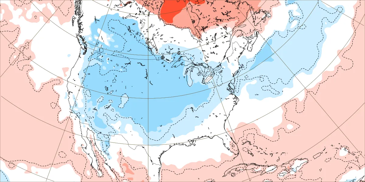
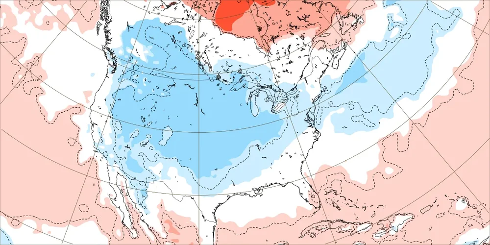
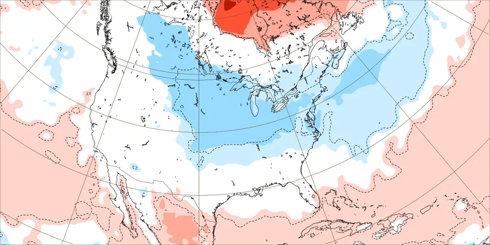
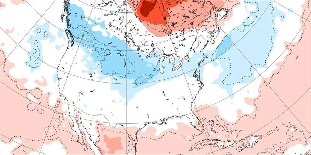
Euro Weeklies: coldest run yet for 1st 3 weeks in Dec for US overall. The maps don’t even have a speck of warmer than normal in the entire Conus except for S TX and S/C FL. Dec 1-7: Dec 8-14: Dec 15-21:
-

11-9/11-10 Early Season Snow Obs.
Holston_River_Rambler replied to John1122's topic in Tennessee Valley
Maybe some pareidolia on my part, but it almostlooks liek there is a little boundary running from central KY to near Greene county, TN: -

11-9/11-10 Early Season Snow Obs.
Save the itchy algae! replied to John1122's topic in Tennessee Valley
Sorry for the bad grammar. A fierce band is moving into Knox. . -
11-9/11-10 Early Season Snow Obs.
Save the itchy algae! replied to John1122's topic in Tennessee Valley
The band that is approaching west Knox moved through my area was fierce. . -
BWI: 14.8 DCA: 11.0 IAD: 23.5 RIC: 7.0 Tie Breaker SBY: 11.5
-

11/8-11/10 First Snow and Lake Effect Event
KeenerWx replied to Geoboy645's topic in Lakes/Ohio Valley
Band dropped another 1.2” on its march back east. Three day total now at 8.3”. Most significant November event, locally, in my lifetime. Top tier lake event, too, but I don’t immediately know where it lands. Crazy that we’re already like 60-70% of the total seasonal snowfall for each 23-24 and 24-25. Hope the curse is lifted and there’s more fun to be had this winter. -
That winter, particularly February, was notable because of a huge noreaster from NJ north, and Mt Washington got 49" in 24 hours, or a total of 91" over 3 days. See 100 hour snowstorm: The 100-Hour Snowstorm of February 1969 | NOAA Climate.gov Another one just before that hit western NC and northern SC with up to 2 feet. There was a thread about it on this very forum: February 1969 Foothills/Piedmont Deep Snowstorm - Southeastern States - American Weather There was almost no noteworthy events for Dec and Jan. With strong greenland blocking and a strong aleutian ridge, it was probably cold and dry along the SE and east, much like a modern La Nina pattern we've been seeing over the last several years - only colder. In a modern climate, probably little or no snow, just a few degrees warmer. Then in Feb, a ridge began to build over the rockies while the greenland block continued, and then those two big storms happened.
-

2025-2026 Fall/Winter Mountain Thread
Maggie Valley Steve replied to Buckethead's topic in Southeastern States
23 with light to moderate snow at times. It's starting to lay on the grass and roads now. -
IMO, we'll know for sure by Christmas. If all the hopes, prognostications, and predictions of December coming in cold, and potentially snowy, end as a mirage or just a "kicking the can pattern" then we know we're in for a miserable winter.
-
Interesting obs: radar filling in over the Lee with virga, it’s now completely overcast here. What id give to see a little Lee side trough form.
-

November 2025 general discussions and probable topic derailings ...
tamarack replied to Typhoon Tip's topic in New England
My brother and extended family have lived in Leland, just west from Wilmington, for almost 15 years and they love it. (Except when Florence barged in. They "vacationed" in Charlotte for that event. He said their house was engineered to withstand 130 mph, though heavy objects at half that speed might be damaging.) -
You don't expect to have to sweep your satellite out in November.
-
.thumb.png.4150b06c63a21f61052e47a612bf1818.png)
November 2025 general discussions and probable topic derailings ...
HIPPYVALLEY replied to Typhoon Tip's topic in New England
I wonder how often someplace in the deep south beats SNE to first flakes? -
It's a fog cloud look out there right now. You hope for this on a good day in Dec-Feb.
-
Yes I did. We did hit whiteout a couple of times, just didn’t get a good picture of it.
-

11/8-11/10 First Snow and Lake Effect Event
sbnwx85 replied to Geoboy645's topic in Lakes/Ohio Valley
A new snowfall record was set in South Bend Sunday. 8.2" of snow fell. The old record for this date was 8", in 1913. The jackpot in the IWX CWA appears to be Walkerton with 14". Round 2 is starting now .
-
Wind
-
I saw a flake… maybe 2 in Old Fort.
-
 Snow falling in the Atlanta area.
 -
We have been in another whiteout. About 1.5 inches today approximately.
-
Flurries
-
I hope you just looked outside. full on whiteout conditions!!
-
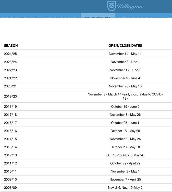
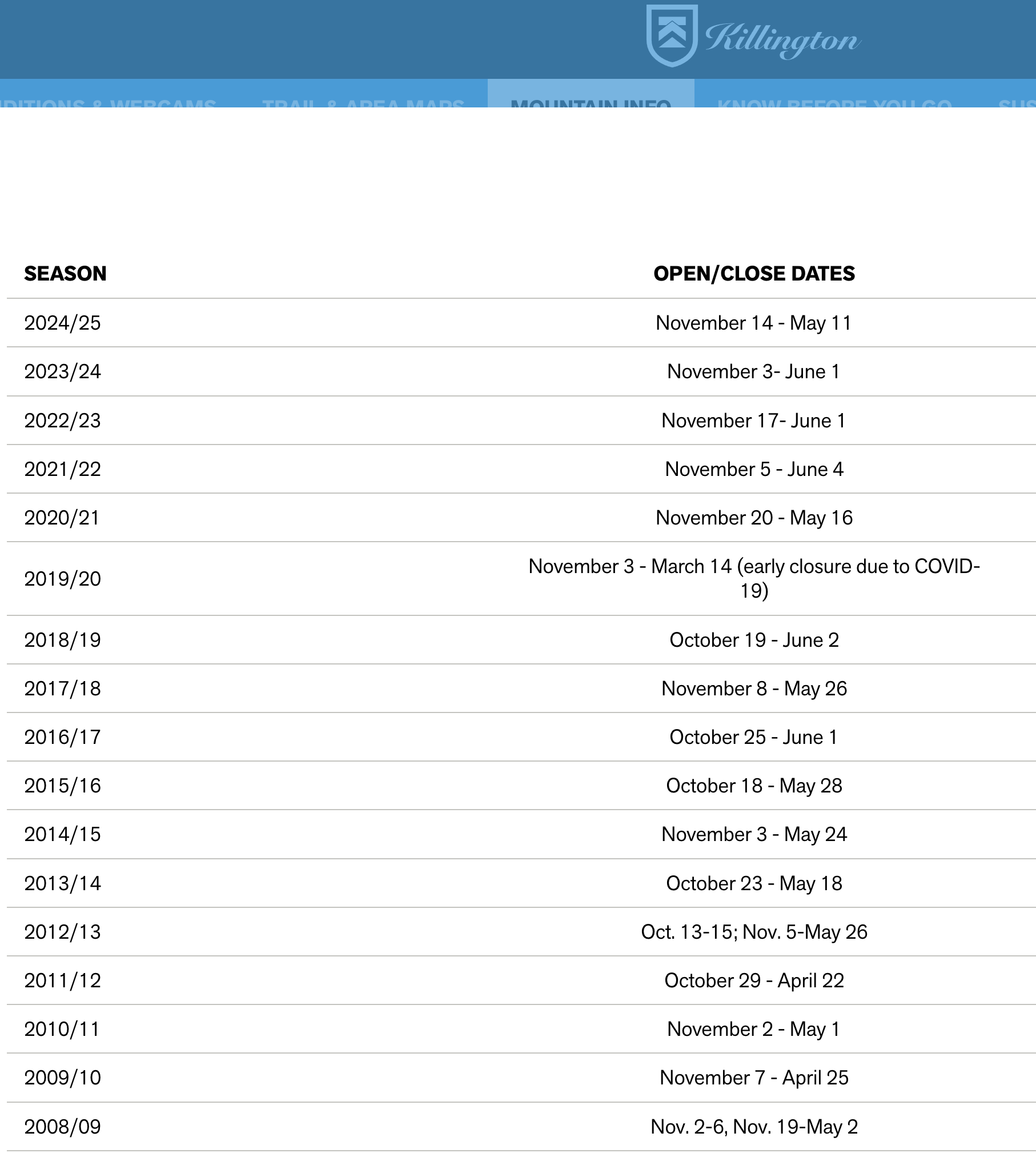
Looks like this Wednesday November 12th it is for opening day this season.