All Activity
- Past hour
-
Meanwhile I get an email from American water telling me we're in a drought warning
-
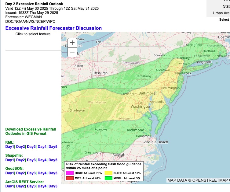
Latest Excessive Rainfall Outlook 12Z Fri. - 12Z Sat. Slight Risk perhaps suggesting max rainfall centered a little further west of latest NAM totals. Or maybe just Flash Flood Guidance is indicating lower tolerance for heavier rains / some flooding further west.
-
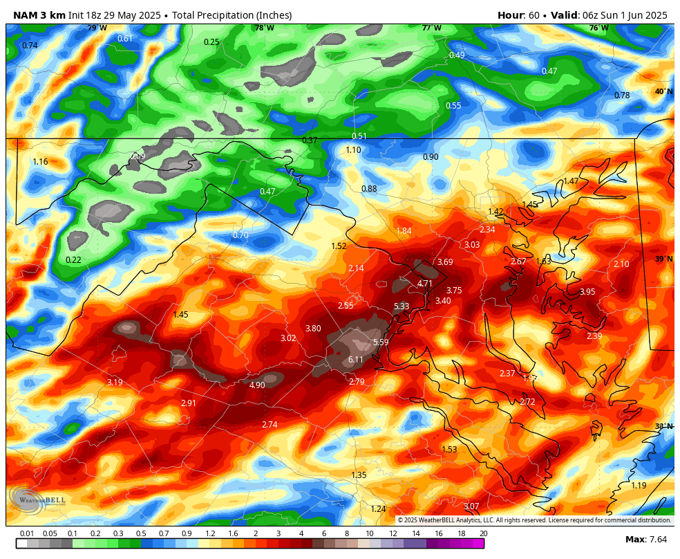
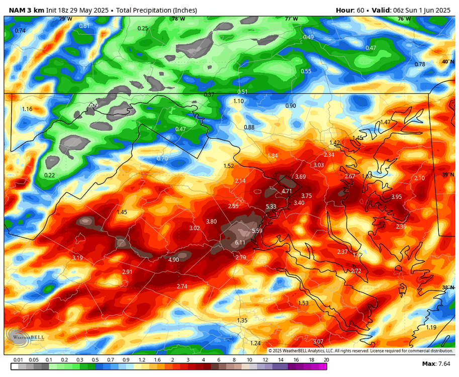
WB 18Z 3K NAM
-
Montauk drizzle
-
Hard to get well into the 80s with ocean influence.. if we turn the winds WSW somehow then game on..
-
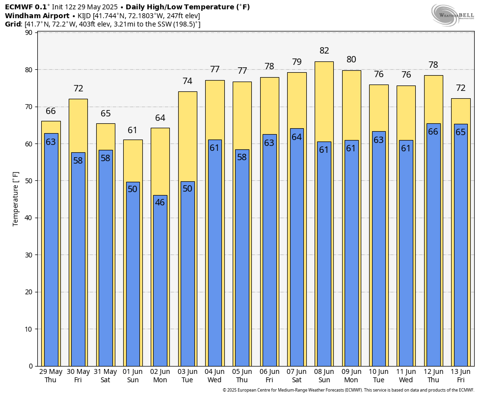
Take all those up 4-8 degrees and you’ve got what reality will be next week . 80-88.. maybe one day of 90
-
Sundays not
-
I don't need to install until the overnight lows stay above 65 and the DP is greater than 60, which is usually mid to late June for my back yard
-
no one said cold.. 70s yes. maybe Thursday could be low 80s but it wont come with days of oppressive dews like you said.
-
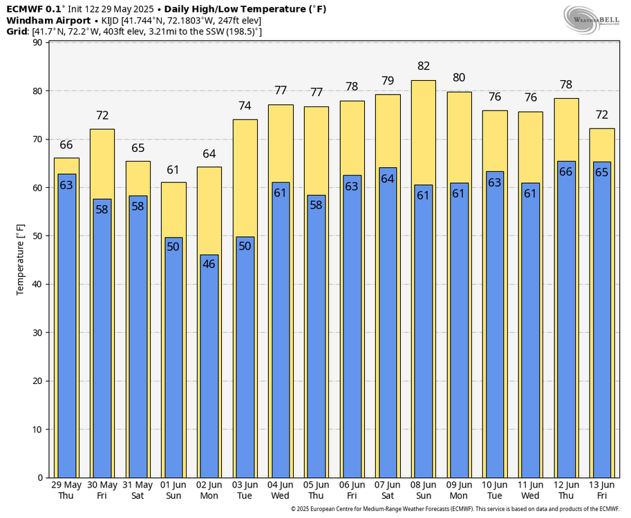
Breaking news … Highs of 74-82 in the first third of June! If those highs verified it would be slightly BN.. it’s an overall AN pattern but that damn cutoff low to our south prevents heat from building in.
-
NAM is very wet
-
So the weekend is a washout.
-
It’s called summer. It does tend to get warm. I will install this weekend. Maybe I wind up using it next week.
-
Excessive Rainfall Discussion NWS Weather Prediction Center College Park MD 333 PM EDT Thu May 29 2025 Day 2 Valid 12Z Fri May 30 2025 - 12Z Sat May 31 2025 ...THERE IS A SLIGHT RISK OF EXCESSIVE RAINFALL FOR PORTIONS OF THE OHIO VALLEY AND MID ATLANTIC... ...20Z Update... Continued increases in the forecast rainfall from the 12Z guidance suite, sufficient instability for storms, ample upper level forcing from a strong shortwave that rapidly turns negatively tilted, and soil sensitivity due to recent heavy rainfall have all worked to increase the concern for flash flooding across portions of the Ohio Valley and Mid-Atlantic Friday and Friday night. Generally, the convection will track from west to east...so the portion of the Slight in Kentucky really focuses on Friday morning, whereas the portion in northern New Jersey is primarily focused on after midnight Friday night. Soil sensitivity to flash flooding is high as soil moisture levels remain well above the normal for this time of year due to rain as recently as yesterday, and not including any shower and isolated thunderstorm activity probable around the DMV region the afternoon and this evening. Further, possible repeating rounds of heavy rain on Friday interacting with the terrain and full rivers should cause onset of flash flooding to occur sooner...closer to the rainfall start time...in these areas, making any potential flooding more hazardous in West Virginia. Further east, urban concerns will increase the potential impacts from flash flooding. The storms will also occur in the afternoon and evening, during the diurnal warmest time of day, which will add more instability for the storms to feed on. Given all of the above, have introduced a higher end Slight from eastern Kentucky to the Baltimore metro. The 12Z HREF suite shows an over 50% chance of exceeding 6-hour FFGs across the DMV. The Slight Risk area was expanded northeast across the Philadelphia Metro and much of northern New Jersey with this update. While the storms will impact this region Friday evening and into the overnight, here too recent heavy rainfall will make flash flooding more common compared to if the soils were dry. By Friday evening a coastal low will be rapidly forming, and so instability will be waning as the precipitation shield evolves into more of a comma shape, with the heaviest rains along the Delaware River on the cold/more stable side of the low. Nevertheless, remnant instability and long duration of rainfall will still cause widely scattered instances of flash flooding.
-
We told and told and told and ACATT said no.. it would be cold
-
https://x.com/ericfisher/status/1928182039733321946?s=46&t=096JqkIpgJTvSWddnDYqdA Fish has been hacked by someone in Tolland
-
So nice out right now, partly sunny and 75 Yikes at LWX talking about tomorrow night's rain: "Rainfall amounts of 1-2 inches are likely in the favored zone of forcing, but CAMs suggest localized totals over 4 inches are possible."
-
Don’t worry, they are now raping the land with solar farms. More dust storms on the way
- Today
-
Golf courses must not be off to a great year with all the rainy weekends. 2 months, at least down here pretty much down the tubes. A lot of momentum is built early.
-
I've only played owl's nest.
-
That sucks
-
Oh, Will doesn't seasonal this engagement based on user contribution and content... He leaves because he doesn't give a ratz azz about warm weather climo - unless it's ( probably...) something truly extraordinary, which this land that god forgot region of the planet doesn't seem to incur enough to waste his time. That's why the man opts out. Believe me ...there's just as much and probably actually more so in the way of bonehead squabbling and tedious nimrodery that goes on in the winter, too.
-
little TDS just southeast of Atlanta
-
The Great Barrington tornado
-
Frederick does a good job of site location and crowning the middle of the field. 2nd and 3rd grade playoffs start this Sunday