All Activity
- Past hour
-
EJ posted FOLKS, remembered he wasn't randy and deleted it.
-

“Cory’s in NYC! Let’s HECS!” Feb. 22-24 Disco
ineedsnow replied to TheSnowman's topic in New England
I didn't even see your post first -

“Cory’s in NYC! Let’s HECS!” Feb. 22-24 Disco
OrangeCTWX replied to TheSnowman's topic in New England
Woah -
So close for more. I would take this instantly though
-
I think there'll be some serious thundersnow potential by the shores or just inland of New Jersey or Long Island
-

“Cory’s in NYC! Let’s HECS!” Feb. 22-24 Disco
weatherwiz replied to TheSnowman's topic in New England
This is pushing historic territory -
lol amazing
-
Big time rates near Waitsfield VT, several inches down already
-
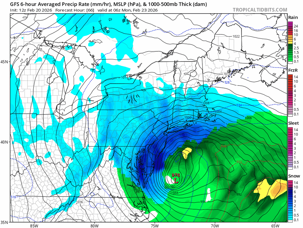
This run of the GFS is so tucked that coastal NJ probably dry slots very late Sunday night.
-
got to get prepared tomorrow got to buy milk and bread..
-

Central PA Winter 25/26 Discussion and Obs
pasnownut replied to MAG5035's topic in Upstate New York/Pennsylvania
GFS tryin to stay lead dog and makin HH a bit happier. WOOF nicely tucked and a bit further W. I agree that we are runnin outta room, but little wiggles like this are totally fine by me. -
Absolute crush job.
-
“Cory’s in NYC! Let’s HECS!” Feb. 22-24 Disco
ineedsnow replied to TheSnowman's topic in New England
Holy shit! -
Good god
-

“Cory’s in NYC! Let’s HECS!” Feb. 22-24 Disco
CoastalWx replied to TheSnowman's topic in New England
Holy shit -

“Cory’s in NYC! Let’s HECS!” Feb. 22-24 Disco
WxWatcher007 replied to TheSnowman's topic in New England
Crushahhhhh -
Omg LI crushed!
-
biblical
-
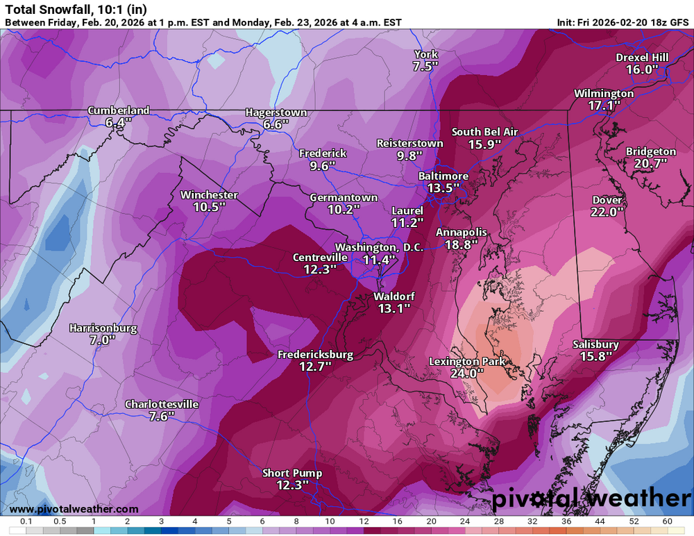
this looks ideal for a 20-30" band across the metro
-
GFS is a folks
-
I was saying it this morning and unless it loses it i will say it again The GFS for this storm was the NAM for Jonas in Jan 2016. The NAM absolutely locked in on that storm and then every model trended towards it. Same thing has happened with the GFS.
-
Woah
-
still a bit more to come for east of the bay after this panel.
-
More tucked.
-

“Cory’s in NYC! Let’s HECS!” Feb. 22-24 Disco
Damage In Tolland replied to TheSnowman's topic in New England
Everywhere 50+ winds and not powder


