All Activity
- Past hour
-
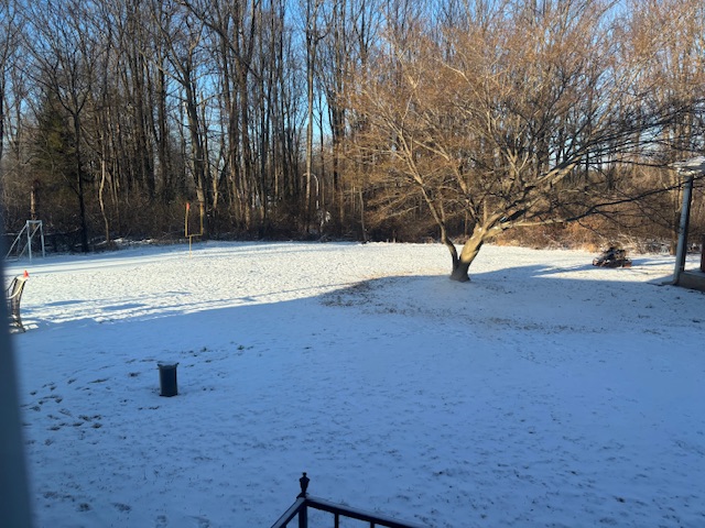
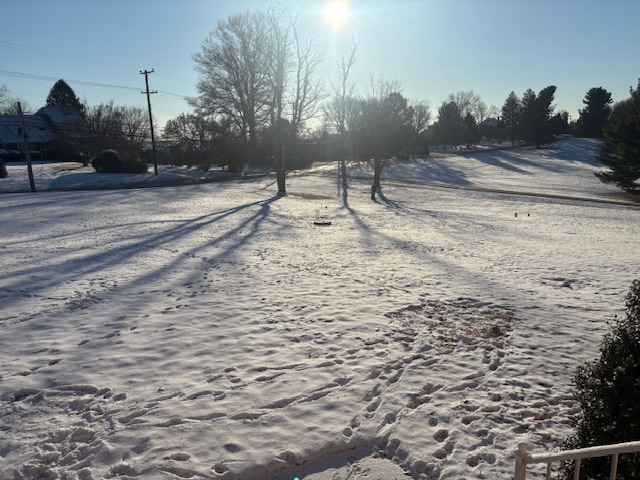
This weekend was absolutely amazing. Reminds me of winters of childhood. It was a long duration snowfall that dropped a good amount of snow. I feel like in the past decade when we get snow it is all much quicker and heavier. This was a nice steady snowfall. Looking ahead it looks great!
-
I mean the constancy here is great. Hope it has the right idea. Last 4 runs of euro ai.

-
We had not-even-close-to-accumulating flurries so I'm pretty sure they'll be a T. The discussion in this thread about slick streets is a completely different world from what we experienced around DC.
-
Too far out guys. Wait til Wed to start getting excited. Just going by my own unscientific observation: when this forum starts tracking 7 days out like its 2 days out, it never works out as planned.
-
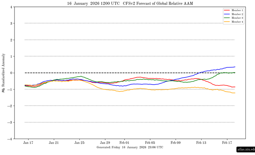
Found these 0z comparisons at Dacula Wx...stilll working to find the AI verification in comparison. They have data fo the last calendar year. Notice the UKMET verification at 5 days? It is almost as bad as the GFS. The EPS and Euro models score highest at d4-5. The WPC medium range desk(conveniently? lol) scores the highest. The closer to the 1 models get...the better they are.
-

January 2026 regional war/obs/disco thread
WinterWolf replied to Baroclinic Zone's topic in New England
Certainly have to give them some weight now after what just happened over the weekend…no denying that. Will they be correct again is the question. Interesting. -

January 25/26 Jimbo Back Surgery Storm
NorthHillsWx replied to Jimbo!'s topic in Southeastern States
AI models did well this past weekend with temps. Different setup entirely but both kept central NC in 40s for most of storm while others were way too quick to cool -
Not a bad little weekend storm.
-
One would think the AI models would excel in a situation like this. I think the conventional wisdom that overrunning systems generally end up north of where originally modeled is the type of thing the AI models would "know" from historical data, which the models incorporate. OTOH, if this is the "rare" time the physics-based models are correct, the AI versions will have egg on their face.
-

2025-2026 ENSO
donsutherland1 replied to 40/70 Benchmark's topic in Weather Forecasting and Discussion
A westerly wind burst appears to be developing. However, at present, it has not yet translated to the surface, as the SOI has remained at or above +20 for four consecutive days. The most recent ENSO Region 3.4 anomaly was -0.7°C during the week centered around January 14th. That's almost identical to its six-week moving average of -0.68°C. So, at least through the most recent week, the La Niña has been remarkably stable. The La Niña should gradually weaken, not collapse. Weekly ENSO Region 3.4 values could rise to neutral-cool levels late this month or during February. However, the fade appears likely to be gradual. As a result, La Niña will likely continue to exert an influence on the atmosphere through at least the first week of February. The AAM- is consistent with a La Niña-type pattern. The WPO-/EPO-/AO-/PNA+ pattern will likely be the biggest driver of North American weather conditions through the remainder of January. That pattern is typically the coldest January pattern for the eastern half or third of the U.S., along with at least southern Ontario and Quebec. One or more lows in the single digits and one or more highs in the teens is possible in New York City. Subzero cold is likely in places like Chicago, Detroit, and Toronto. The predominantly positive PNA comes with a heightened risk, relative to climatology, of moderate or significant snowstorms for the East Coast. With the PNA likely to be mainly positive into or through at least the first week of February, it is likely that at least one or more of the following cities will see at least one 6" or above snowstorm from the remainder of January through the first week of February: Baltimore, Boston, New York, Philadelphia, Richmond, and Washington, DC. Warmer than normal conditions will generally prevail in the Southwest.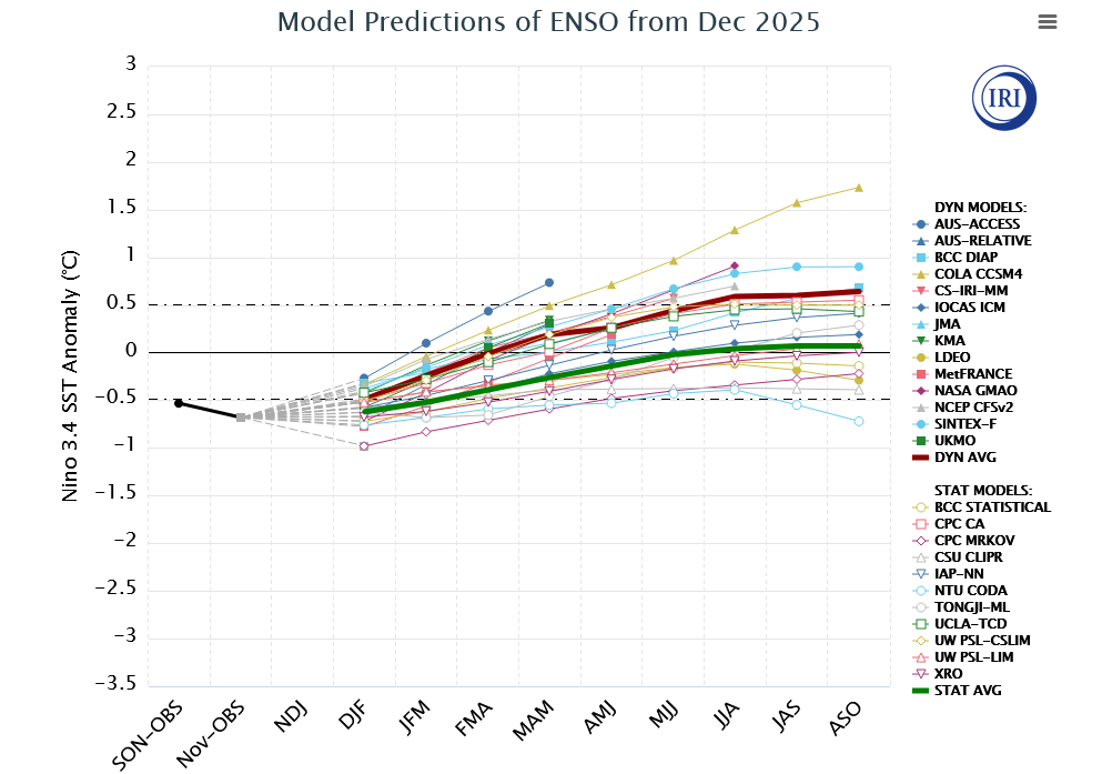
-
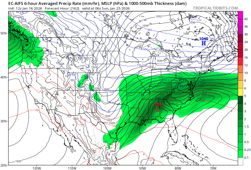
This winter storm will be a pivotal moment in modeling history. It's the AI models (apparently Google's AI, WeatherNEXT, showed an Euro AI solution after being slightly south) vs the physics models. This storm could change our perspective of current modeling—we may crown a new king.
-
January 2026 regional war/obs/disco thread
WinterWolf replied to Baroclinic Zone's topic in New England
I’ll be traveling so it’s why I’m asking…if this does come north for SNE, are we looking more of a Sunday noon or after deal for us? I know we’re talking 6 days out here, and maybe it never even gets up in here…but if it did, what’s the timing looking like at this moment? -
The Euro at 105 is bringing out the shortwave from Baja. Its like its 240 hours out. I would hope that kind of model can nail this at 105
-
Both the EPS and GEFS eject significant energy eastward from upper low moving southward towards Baja.
-
My opinion- this storm is looking like like your classic old school CAD overrunning that we haven't seen in a long time. 3-5 inches of snow, and inch or 2 of sleet and .25 of ice that turns into an iceberg for days. Thats just what it looks like right now for us foothills folks. More snow the further NE you go, more ice toward SC.
-

Rise of the Machines: January 18-19 Winter Storm Obs Thread
ORH_wxman replied to WxWatcher007's topic in New England
Ripping fatties here in this stuff.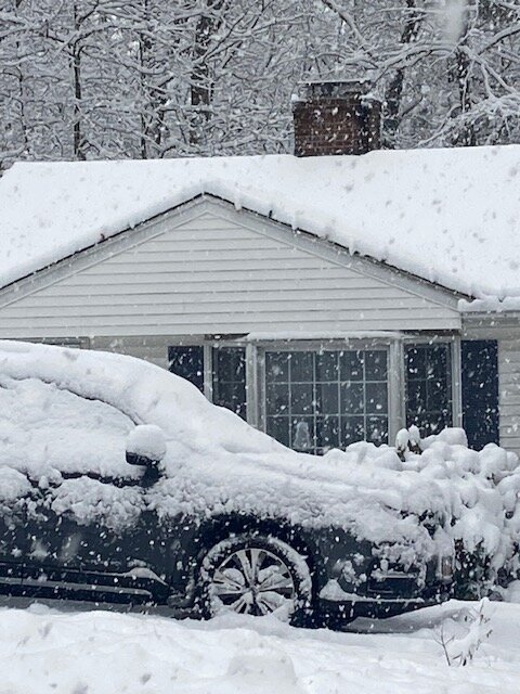
-
Also notice the PV is more east on gfs than euro, aifs, aigfs
-
The Euro AI solution. I’m less concerned about less snow and more concerned about more ice! Someone is going to get at gnarly ice storm out of this and I hope it's not our forum.
-
Some of us will need a cliff to jump off of. Feel free to jump here. Let's try and keep the one liners and weeping and nashing of teeth off the main thread.
-
16 here as well. .
-

January 2026 Medium/Long Range Discussion
SomeguyfromTakomaPark replied to snowfan's topic in Mid Atlantic
Just blend all guidance and our region is the cross hairs. We may finally get the region wide storm we’ve needed for about a decade. -
16 here this morning. Ground will be cold for anything frozen that falls.
-
I was noticing the AI models pushing the warmth further north. Was surprised no one posted about it. I guess we only post what we want to see. I am sure the next 5 days will be a rollercoaster as usual. I just hope we can keep that ZR down at a minimal amount. The Euro AI is actually showing some warmish temps through the storm to keep ice totals down. Should be an interesting week to track.
-

January 2026 regional war/obs/disco thread
SouthCoastMA replied to Baroclinic Zone's topic in New England
Im convinced the AIs are going to lead the way on this. ride them in the mid range for storm track, 500 trough positions -
That was a great set of runs overnight. Something nice to wake up to! Other than the EURO. Lets get that shifting back down south, please!