All Activity
- Today
-

Texas 2025 Discussion/Observations
Stx_Thunder replied to Stx_Thunder's topic in Central/Western States
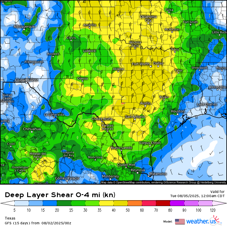
Sunday - Monday looks to be the most convectively interesting the next few days with a potential MCS or at least a few MCCs. Both Euro & GFS holding fairly strong on a formidable mid-upper northerly flow and some unusually decent DL shear this time of year (possibly over 40 knots) over a good chunk of the state on the eastern side of the furnace High moving off to the west. Steering some stout mid-level shortwave energy south through the state. Especially on Monday. Euro has been a bit sketchy on shear value trends in most recent runs. But GFS has been staying mostly consistent the past few days.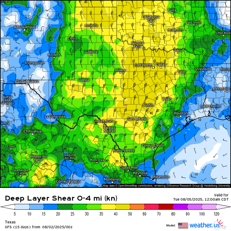
-
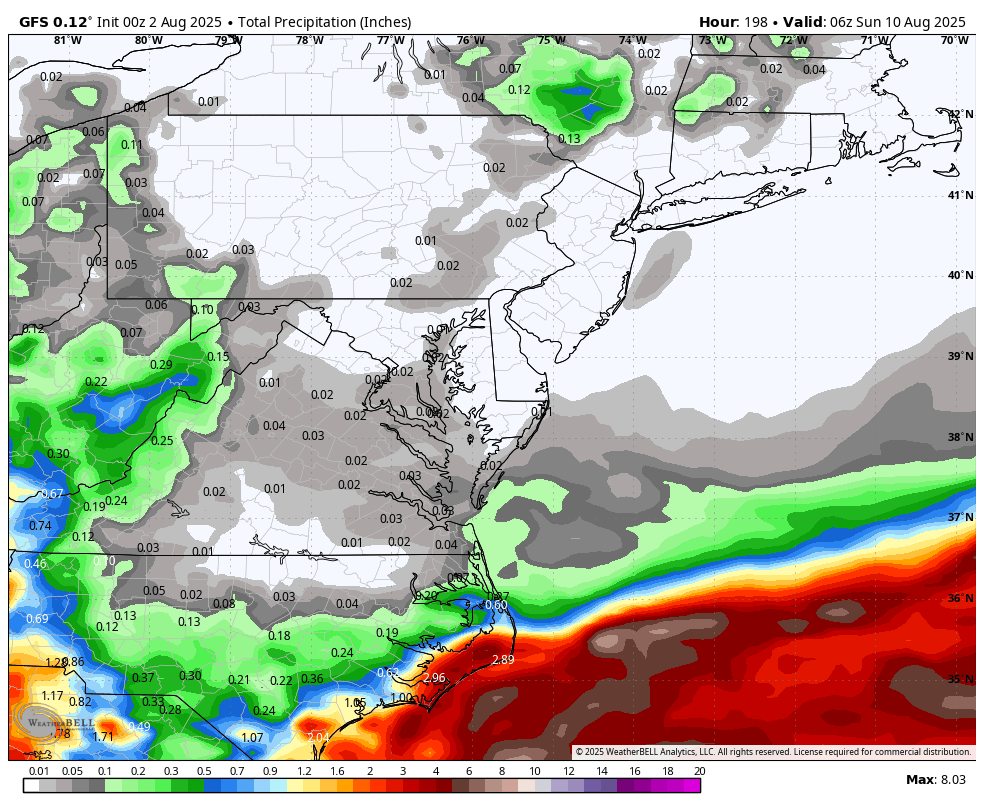
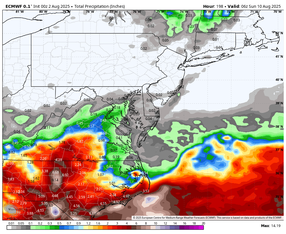
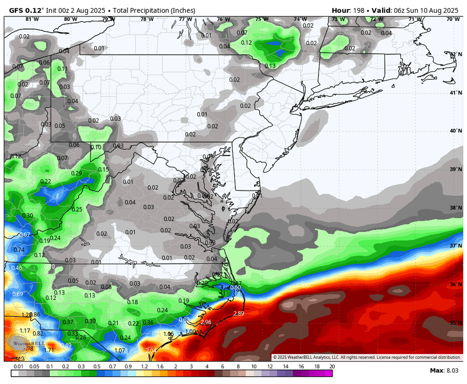
WB OZ GFS and EURO now both dry for the week ahead.

-

2025 Atlantic Hurricane Season
WxWatcher007 replied to BarryStantonGBP's topic in Tropical Headquarters
I still think 1-2 TCs before August 20, but I’m increasingly bullish for my peak season forecast (again). -
He’s not wrong about the general steering potential. A US landfall pattern has been there much of the summer, just haven’t had the activity. Don’t need Webb to see it. Once tropical waves start surviving the trek across the more stable tropical Atlantic and reach the SW Atlantic, there will be landfalls.
-
 Totally forgot DCA _ NYC _ BOS ___ ORD _ ATL _ IAH ___ DEN _ PHX _ SEA +1 +.8 +1 +.9 +.6 +.5 +1.5 +1.8 +1.6
 -
Cerro Castor ski resort is still getting heavy snow and it is blowing around. It's deep winter down in deep southern South America and the skiers there are happy. It's gonnabe the scene in the Mid Atlantic come December 2025 on into the first three months of 2026. Remember you heard it first from The Jebman!
-
0Z UKMET NEW TROPICAL CYCLONE FORECAST TO DEVELOP AFTER 156 HOURS FORECAST POSITION AT T+156 : 16.9N 48.9W LEAD CENTRAL MAXIMUM WIND VERIFYING TIME TIME POSITION PRESSURE (MB) SPEED (KNOTS) -------------- ---- -------- ------------- ------------- 1200UTC 08.08.2025 156 16.9N 48.9W 1012 25 0000UTC 09.08.2025 168 18.4N 51.5W 1012 26
-
The CANSIPS busted horribly on its July forecast from a 0.0 month lead, in terms of US temperatures. The Euro is a much better performing seasonal model, but I don't know when its monthly forecasts update. The Euro though performed really badly for last DJF, I'm surprised seasonal models don't do better.. they seem to heavily weight ENSO. The year before (23-24) the Euro kept showing cold H5 over the Mid-Atlantic for the Winter mean. We got almost no snow that Winter, and it was the warmest Winter on record for the CONUS. The -PDO/east-based El Nino analog composite for 23-24 worked very well, though.
-
We've had a really strong/consistent North Pacific High pressure pattern (-PNA), especially in February and March. It's a pattern, and is associated with cold-phase ENSO and PDO. The anomaly Feb-March 2018-2025, for a 8-year-consecutive period, actually breaks #2 on the all time anomaly list by +30%. Then in the Atlantic we have had 14 straight positive or neutral NAO Winters since 2011-2012. In that time, 18/18 Winter months (DJFM) with a NAO value >1.11 have all been positive [CPC]. We've had some -AO and -EPO periods during that time, which have delivered very strong arctic shots to the Midwest, but they have not been long lasting. Why is this pattern occurring? A possibility is the low sunspots 2003-2022, as that 20-year period had the lowest sunspots, since the 1800s. There might be a lag, so the strong rebound of Solar activity over the last 2 years may help change up the pattern going forward (my theory). We may also be in a decadal +NAO phase, which could last about 20 more years, just based on the wave fluctuations over the last 150 years. We also seem to be a the peak of a -PDO phase (cold ENSO-like), with October 2024 and probably July 2025 having the lowest monthly readings on record.. it could take some time to neutralize or change that long term state, which started in 1998.
-
 Been hearing the crickets and Katydids for a bit now actually. Love it.
 -
You’re such a data nerd. Love it.
-
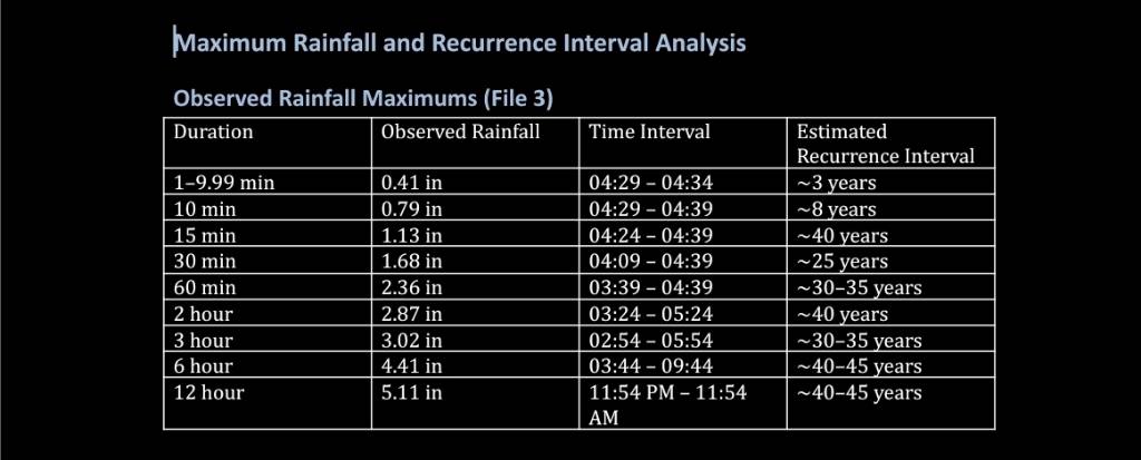
Here was my data from the tropical system August 9th, 2024. My favorite stat there is I received roughly 1/4 (~22%) of my storm rainfall from that (6-12 hour) tropical system in 15min. Sent from my SM-X210 using Tapatalk

-
 I'm almost 7 degrees colder than LGA only a few miles east.
 -
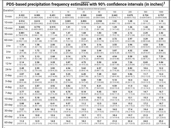
I thought you might enjoy this. I focused it for Mt Joy. It's the precipitation recurrence interval for different time periods. Sent from my SM-X210 using Tapatalk
-
If only things cost now what they did back then. I was just a wee lad when it was this cold in 1965. In 1881 the year of my birth it would actually snow before the euro started to show the north trend
-
52/46 at 10pm. Windows open and let’s get those leaves changing .
-
The third H won’t be really noticeable in my hood for a bit.
-
Time for a new approach this winter: If any model run shows something that hasn't happened in 10 years...ignore it
-

2025 Spring/Summer Mountain Thread
Maggie Valley Steve replied to Maggie Valley Steve's topic in Southeastern States
No severe thunderstorms here today, but we did have a couple good downpours! Cooler weather ahead with lows in the 50's and highs in the low 70's. Surely Fall is approaching and before long it will be leaf season. -
it's amazing how this forum was once a ACATT hotbed then you see and view the families, the friends appreciating and embracing HHH to the fullest; acclimating, adjusting, seeing and feeling it. It becomes second-nature, it's wholly embraced and predictable
-
thank you china
-
Thus far, that is the theme! But weighted HHH <3
-
Forest fire smoke
-
Hey at least we could check out early and just ignore this altogether till next hear, lol But oy...it amazes me how the snow completely fell off after Jan 16. I had been under the impression that change in climo was more gradual...but it's like somebody flipped a switch in 16, and the clippers disappeared and so did some of our ways of getting snow. I get changing climo but I don't understand why it happened so fast. I wish someone would study what exactly happened that year and why every year since has done, well....what we've seen.
-
1.4