All Activity
- Past hour
-
Bring on that much needed heat we been missing and those sultry dewpoints as well.
-
THIS. It has been quite awhile since we have had a good region-wide soaking rain over a long period of hours. Really, REALLY welcome.
-

2025-2026 ENSO
so_whats_happening replied to 40/70 Benchmark's topic in Weather Forecasting and Discussion
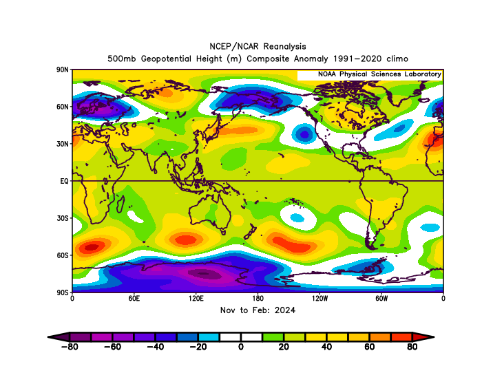
While oceanic temps have definitely increased probably the most drastic of changes has been in the Arctic over the last 50 years I feel this probably is the biggest reason we have been having issues with pattern semblance over the last decade or two, more notably. It may very well be the reason for such changes to the PDO state but im not ready to make those accusations or conclusions. Over the last 5 years the Antarctic has suffered rather drastic changes to the ice sheet I wonder if we start seeing similar results within the southern hemisphere as we have seen in the northern with the idea of permanence taking shape. -
0.85" currently. Very nice regionwide rainfall.
-
what a beautiful, clean phase too...can't buy those in winter
-
2025-2026 ENSO
so_whats_happening replied to 40/70 Benchmark's topic in Weather Forecasting and Discussion
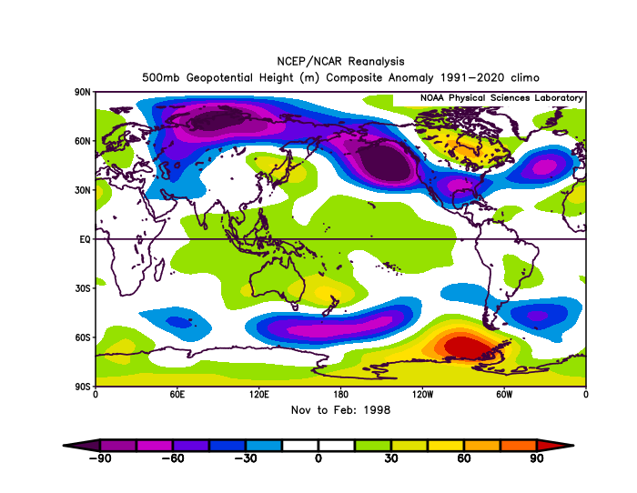
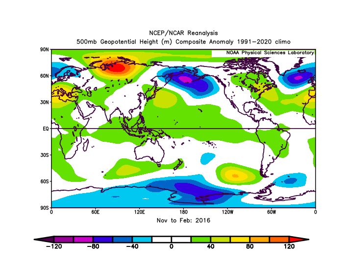
RONI peaked in 2015/16 NDJ of 2.38. ONI of ~2.6 RONI peaked in 1997/98 SON also at 2.38. ONI of ~2.4 https://www.cpc.ncep.noaa.gov/data/indices/RONI.ascii.txt Im personally still not on the RONI bandwagon as being a reasonable indicator of what will occur but to each their own. This type of atmospheric pattern in 2023/24 was closer to the strong/super Ninos even with the RONI showing barely strong status. I included 1972/73 as that was the last deeply -PDO/ +ENSO we experienced of course it is apples to oranges as nearly 50 years of oceanic warming have changed things up a bit.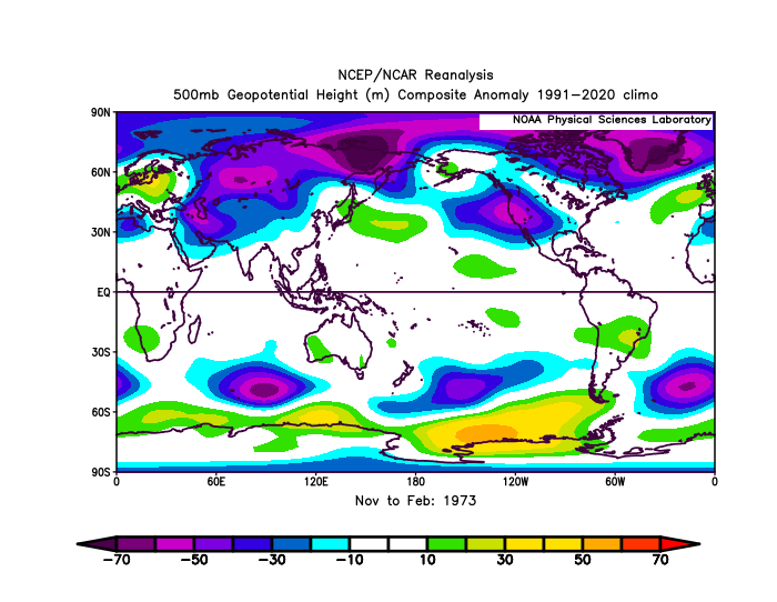
-
But there is a risk for a rogue strong storm or two
-
It is not that simple. Cargo is big money. JFK has the highest value of cargo shipments in the US. Fed Ex has a major hub at EWR. Cargo is very important to the functions of airports. The immediate acute problem at EWR is one of the two main runways being closed. That will end in mid June. The other lingering problems include moving a bunch of disgruntled union employees from Westbury to Philly because they could not longer staff the Tracon on Long Island due to high costs and old housing stock. That will payoff long term as newer employees are more willing to live in the suburbs of Eastern Pennsylvania with its low taxes and cheaper/newer houses and they can actually FULLY staff the Tracon. The other long term problem is fully modernizing the ATC system. That needs funding and attention
-
Saturday looks horrid
-
1.06 and still counting
-
The wet, the cool and the high winds have been relentless.
-
Didn't Tblizz cancel this whole week?
-
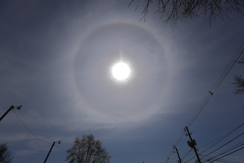
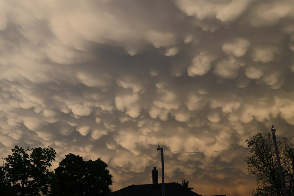
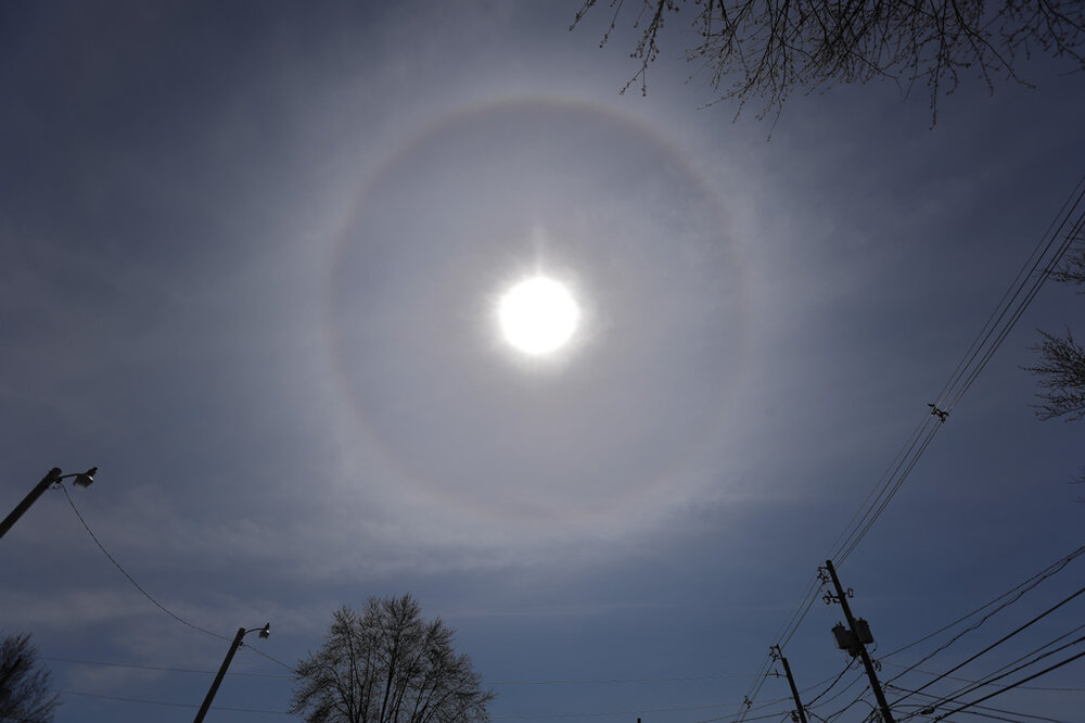
Thank you for asking. Been dealing with some health issues here of late. Here is a 22 degree halo around the Sun in the mid-day cirrus on 4-1 And some mammatus post storm on 5-16

-
I said to the wife this morning that we do extremes quite well here. Told her that once the pattern flips we'll probably go extended dry and warm/hot. Not that I'm complaining about it. Just that it probably happens...
-
Blame it on Robert Moses. All the highways should be torn down and the entire thing needs to be rebuilt from scratch.
-
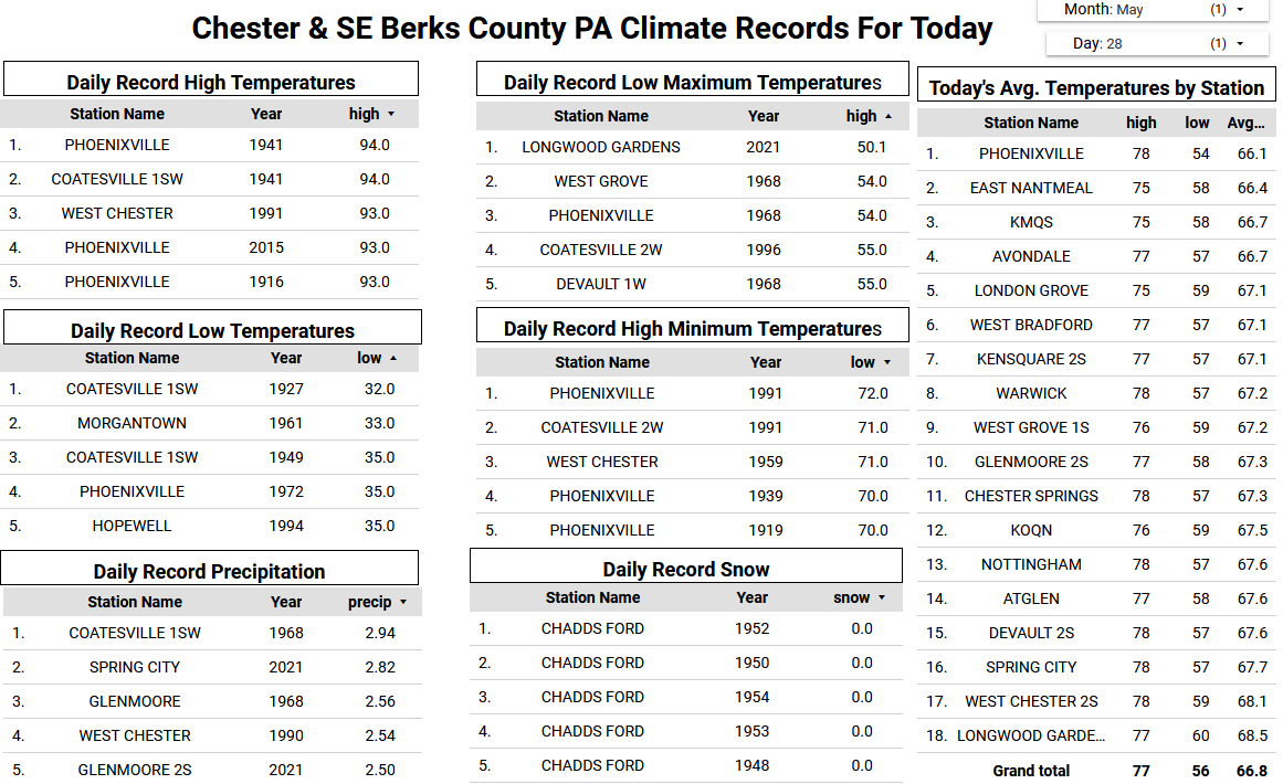
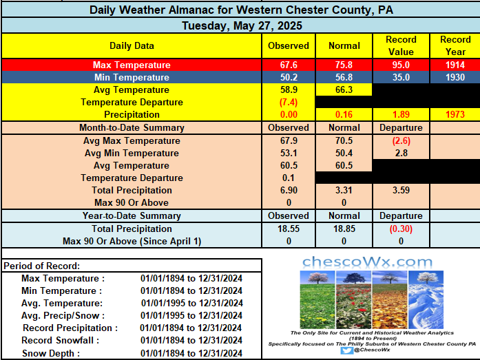
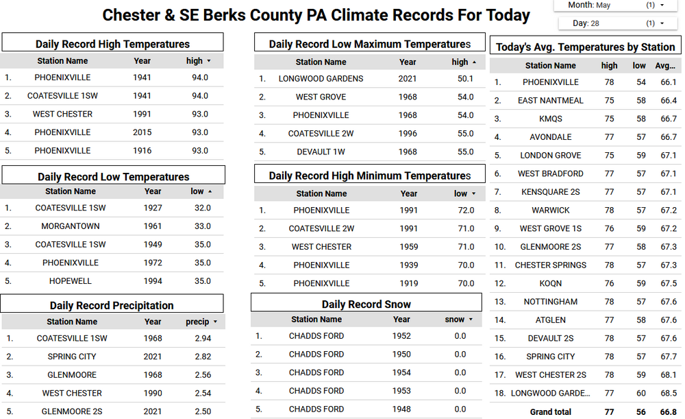
So far in East Nantmeal we have received 0.17" of rain. Over a half inch has already fallen across southern areas of Chester County and down into Northern Maryland. We all should see upwards of another inch of rain today with very chilly temperatures remaining in the mid to upper 50's. This could be yet another top 5 low max temperature this afternoon for some stations in the county. We look to dry out a bit on Thursday before more shower chances arrive tomorrow night into Friday. We should clear it up by later Saturday, but we should see it continued below normal temperatures to close out the month. Of note May appears likely to finish with below normal temperatures for the County. This will mark the 4th below normal month in the last 6 months with December, January, February and now May featuring colder than normal average temperatures.
-

E PA/NJ/DE Spring 2025 Obs/Discussion
ChescoWx replied to PhiEaglesfan712's topic in Philadelphia Region
So far in East Nantmeal we have received 0.17" of rain. Over a half inch has already fallen across southern areas of Chester County and down into Northern Maryland. We all should see upwards of another inch of rain today with very chilly temperatures remaining in the mid to upper 50's. This could be yet another top 5 low max temperature this afternoon for some stations in the county. We look to dry out a bit on Thursday before more shower chances arrive tomorrow night into Friday. We should clear it up by later Saturday, but we should see it continued below normal temperatures to close out the month. Of note May appears likely to finish with below normal temperatures for the County. This will mark the 4th below normal month in the last 6 months with December, January, February and now May featuring colder than normal average temperatures.
-
Typhoon I comprehend a slight cyclical warming world that is not scary or an existential threat. Climate is and remains an inexact science when trying to model the past before 1750....climate that occurred before on earth will of course come again.....simply cyclical no denying that!!
-
Approaching 1.5". Perfect event. Boy, the rubber band has snapped back. Might be an 8" month.
-
To say that was needed for our area is an understatement. Really grateful we have gotten this in May ahead of summer.
-
The problem always remains you cannot prove a National Weather Cooperative certified at the time record as wrong unless you find another station outside of the area (like here in Chester County Pa) and use that as a proxy to then validate the adjustment. That is clearly not science in this man's worldview.
-
I’ve forgotten what good storms are like. Makes me want to return to the plains.
-
Where was this cold, wet pattern all winter?
-
Based on RONI, 2023-4’s peak was only a borderline moderate/strong +1.50 (OND) vs 2015-6’s super RONI peak of +2.038. Even 2009-10’s peak was slightly stronger with +1.56. 2023-24’s DJF RONI then fell to just +1.21. https://www.cpc.ncep.noaa.gov/data/indices/RONI.ascii.txt
-
This weekend or next?