All Activity
- Past hour
- Today
-
 This is a reverse weenie suicide.
 -
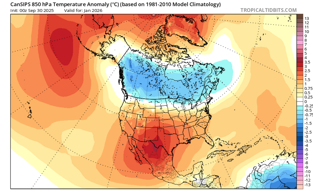
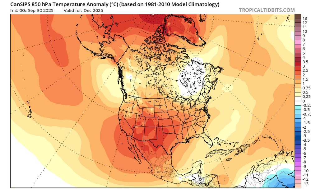
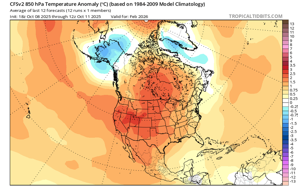
Forgot this. I have the counts for cold waves in the 80-120 ACE La Ninas locally. For whatever reason, the tendency shows the low-solar, low ACE La Ninas seeing severe cold locally late (February) while the higher solar, low ACE, La Nina years see it early (Nov-Dec). So low solar Feb 1955/1985 have the most days 5F or more below average locally. But Dec 1971, Dec 1988, Nov 2000, Nov 2022 have far more solar activity. The years that go to El Ninos, 1971 and 2022, also see higher numbers of cold days in Nov-Dec locally in these La Ninas. My best guest is one big cold outbreak mid Nov-mid Dec for cold, and then smaller outbreaks later. La Nina, 80-120 ACE # Of Days by Month, AVG Temp 5F or colder than daily mean in ABQ Year Nov Dec Jan Feb Nov-Feb 1954 1 9 10 15 35 1971 6 15 8 5 34 1984 6 7 8 11 32 1988 9 11 9 5 34 2000 17 4 12 6 39 2022 14 5 5 7 31 Blend 9 9 8 8 34 # Of Days by Month, AVG Temp 10F or colder than daily mean in ABQ Year Nov Dec Jan Feb Nov-Feb 1954 0 3 3 12 18 1971 0 7 3 3 13 1984 2 3 4 7 16 1988 2 5 5 4 16 2000 10 0 3 0 13 2022 5 0 0 2 7 Blend 3 3 3 5 14 For July-June - 1954-55 is around 19 sunspots, 1984-85 is around 26. 1971-72 is about 101. 1988-89 is around 188. 2000-01 is around 163. 2022-23 is around 110. 2025-26 is probably lower than 2024-2025 (149) but still in the 1971, 2022, 2000, 1988 range.
-

2025-2026 ENSO
40/70 Benchmark replied to 40/70 Benchmark's topic in Weather Forecasting and Discussion
Good stuff. Nice to see raindance posting. We seem to be generally on the same page, but he is a bit colder. -
Yes...we need this rain so bad. Unfortunately, west of here will not cash in much. I am afraid about the upcoming fire season in the mountains
-
JB isn’t happy: Laughable NHC Antics The naming of Karen in the North Atlantic as a subtropical storm is laughable to me, but it has now become a talking point for people pushing missives about climate change. This despite a season that has fallen short of the means of the last 5 seasons, and one of them with a strong el Niño. It underscores what I have been trying to push for close to 2 decades. If you want to name these systems that develop a warmer core within the realm of a colder environment, then you need a 2 tier season. That you would have something like this, which has a nice structure but is a warmer feature within the colder environment and over water temps that are 2-4C °C degrees below the threshold of 26C we use for storms, is a joke to me. In the meantime, look at this on Sept 16 from a storm that developed over the Gulf Stream did this to SE Va, along with causing the collapse of houses into the ocean on the Outer Banks It was totally ignored by the National Hurricane Center. This has been going on since I can remember. I will watch storms get named in the middle of nowhere (we call them ham sandwiches at weatherbell.com), where no one can actually see what they do, but then we see features like this, which are enough to feed back and convert rapidly to at least subtropical systems and hit people, and no one says boo. But a massive overhaul has to be done at the NHC. There is too much subjectivity and that shackles people relying on their expertise, which, btw is considerable, on these matters. —————- Any thoughts?
-
About 1/2” so far. Seems to be meeting expectations. We needed this widespread rainfall. Downright raw right now with a gusty N wind, 60 degrees and moderate rain
-
Does this seem like snowstorm in December for I 95!!??? Uggg
-
NHC has this as a cat 2 right now 48 hours ago on their forecast
-
Models were bad on holding a signal for TC genesis, bad on initially predicting Jerry wouldn’t impact the islands, and then were even worse modeling the environment that led to Jerry’s untimely demise. Rough storm for the guidance on balance.
-
More heavy rain in SLC, too. Closing in on a record wet October.
-
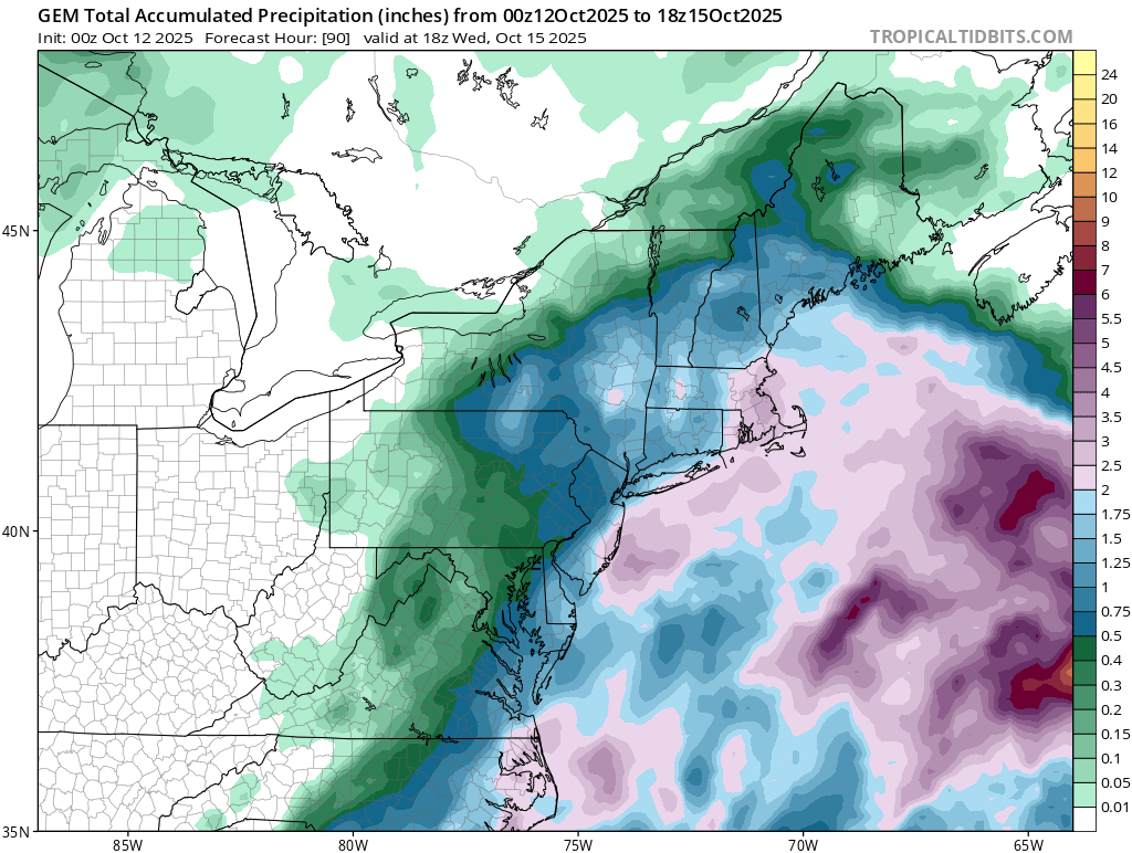
 Literally all models coming in wetter now. Started with the NAMs, now the ICON and RGEM as well
- 329 replies
-
- 2
-

-

-
- heavy rain
- damaging wind
- (and 2 more)
-
I’ve gotten 0.20” the last 24 hours ending 11PM this evening from the trough coming out of the low then off of FL. About all of it fell overnight through mid morning. I’ve received 2.2” MTD.
-
Hopefully the mesos are right with 1-2” up here. HRRR and 3k are soakers.
-

The return of the elusive Nor'easter. Drought buster or bust?
87storms replied to dailylurker's topic in Mid Atlantic
More than sprinkles rn though it’s a pretty isolated batch. Feels and looks like Fall out there. -

Spooky Season (October Disco Thread)
bristolri_wx replied to Prismshine Productions's topic in New England


-
Spooky Season (October Disco Thread)
bristolri_wx replied to Prismshine Productions's topic in New England
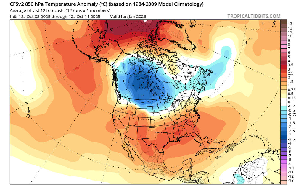
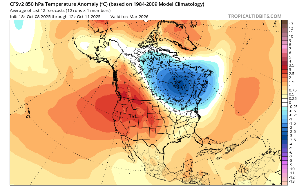
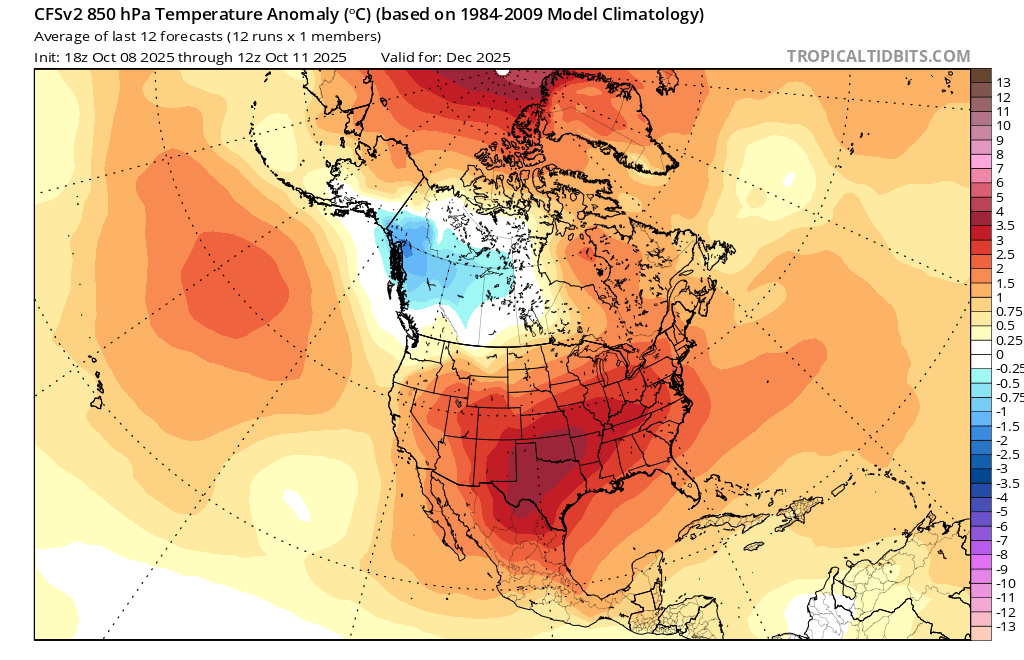
You should upgrade your computer so you can post more than one frame/month of the CFS.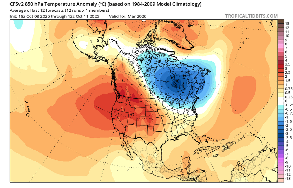
-

The return of the elusive Nor'easter. Drought buster or bust?
ravensrule replied to dailylurker's topic in Mid Atlantic
Please just give us heavier rain and stronger winds between 1-4 pm tomorrow in downtown. -
 Duration and strength of winds also increased a bit.
- 329 replies
-
- 1
-
-
- heavy rain
- damaging wind
- (and 2 more)
-
Such for euro moving south. POS.
-
Euro and AI look decent. Nam too.
-
And like the Ravens and Harbaugh...time for the Terps to move on from Locksley, lol I have a feeling that 2026 is gonna be a much better year for all 3 major MD sports
-

Spooky Season (October Disco Thread)
Torch Tiger replied to Prismshine Productions's topic in New England
h85 and 2m. nothing to worry about !
.thumb.png.bde2e6aec10577cbf003e95544519bde.png)


.png.afa3ba823ba68dc2d81c04893151851c.png)