All Activity
- Past hour
-

Feb 22nd/23rd "There's no way..." Obs Thread
WolfStock1 replied to Maestrobjwa's topic in Mid Atlantic
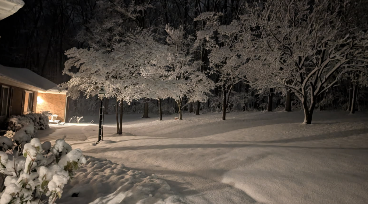
SW of Leesburg VA we got right at 5", so it appears more than most in the area. Was a really sticky and beautiful snow Sunday night. (we got a bit more after the pic was taken)
-

Clipper Fires In Wednesday Feb 25 Disco/ Obs
Chrisrotary12 replied to Damage In Tolland's topic in New England
I’m very confused by this suggestion. -
Does someone actually hang around CPK all day to measure?
-
That's the speculation, when they measured again at 7PM there was no measurable. But they did get additional snowfall from say 1-3PM or so and it melted. If they measured after it stopped snowing they could have reported it and should be above 20". Kind of important to do that since its a top 7 storm of all time. They can add an estimated additional amount in like they did in 2016 when the amount changed from 26.8 to 27.5 nearly 2-3 months later.
-
It stayed cold today, looks like 44.9 gonna be our high. Last winter like day for a while
-
Yeah I ignored the bad data.
-

Central PA Winter 25/26 Discussion and Obs
pasnownut replied to MAG5035's topic in Upstate New York/Pennsylvania
Wont be as fun this time but man would it be nice to wrap up with a doozy. -

Winter cancelled/uncancelled banter 25/26
WeatherGeek2025 replied to Rjay's topic in New York City Metro
black ice alert tonight after the melt! -
One of these years there are going to be quite a few MLB games postponed in March because of cold and frozen precip - Mets open at home March 26 ??? Ridiculous IMO..
-
If they cleared for the 18z ob (idk what they do there but I assume there’s a contract observer) they may have lost any additional due to melting/melting on contact by the time they measured again. I think the temp climbed from 31-33 in that period and eventually to 34 by 00z.
-

Winter cancelled/uncancelled banter 25/26
NorthShoreWx replied to Rjay's topic in New York City Metro
How is it possible that you don't know the answer? -
i think that first one (2010) might be a little off. 55 to -58? lololol
-
Winter cancelled/uncancelled banter 25/26
NorthShoreWx replied to Rjay's topic in New York City Metro
Snow depth and water content are a better way to compare apples to apples. But I still like to see snowfall stats. -
It would’ve been called nor’easter in the yore years. Heavy snow and strong NE winds.
-
Northof78 already opened one a while ago
-
Don can explain in more depth than me but from what i understand they reported 19.7" at 1PM when it was still snowing for a couple hours after that and never updated the snowfall total. Apparently there was an additional 0.15" qpf after the report. This is what i saw on the NYC forums anyway.
-

"Don’t do it" 2026 Blizzard obs, updates and pictures.
Ginx snewx replied to Ginx snewx's topic in New England
Plainfield -
Ya, that(Jan 25th) was a monster SWFE…one for the record books..not a Nor’easter.
-
Don't see any big prolonged torch in the cards with this happening. Even though I'm more than ready for one lol. Luckily, I'm going to the Bahamas on the 11th. So you can probably lock in a March biggie for that week This will probably want to keep the vortex hanging out near Hudson bay. Which has been a preferred locale for it all winter long already. I'm not exactly getting early summer vibes from that idea.
-
2/24 - 2/25 Clipper Obs (1 - 2" for many on forum)
WeatherGeek2025 replied to Northof78's topic in New York City Metro
anyone follow my instagram page? @nycweathernow -
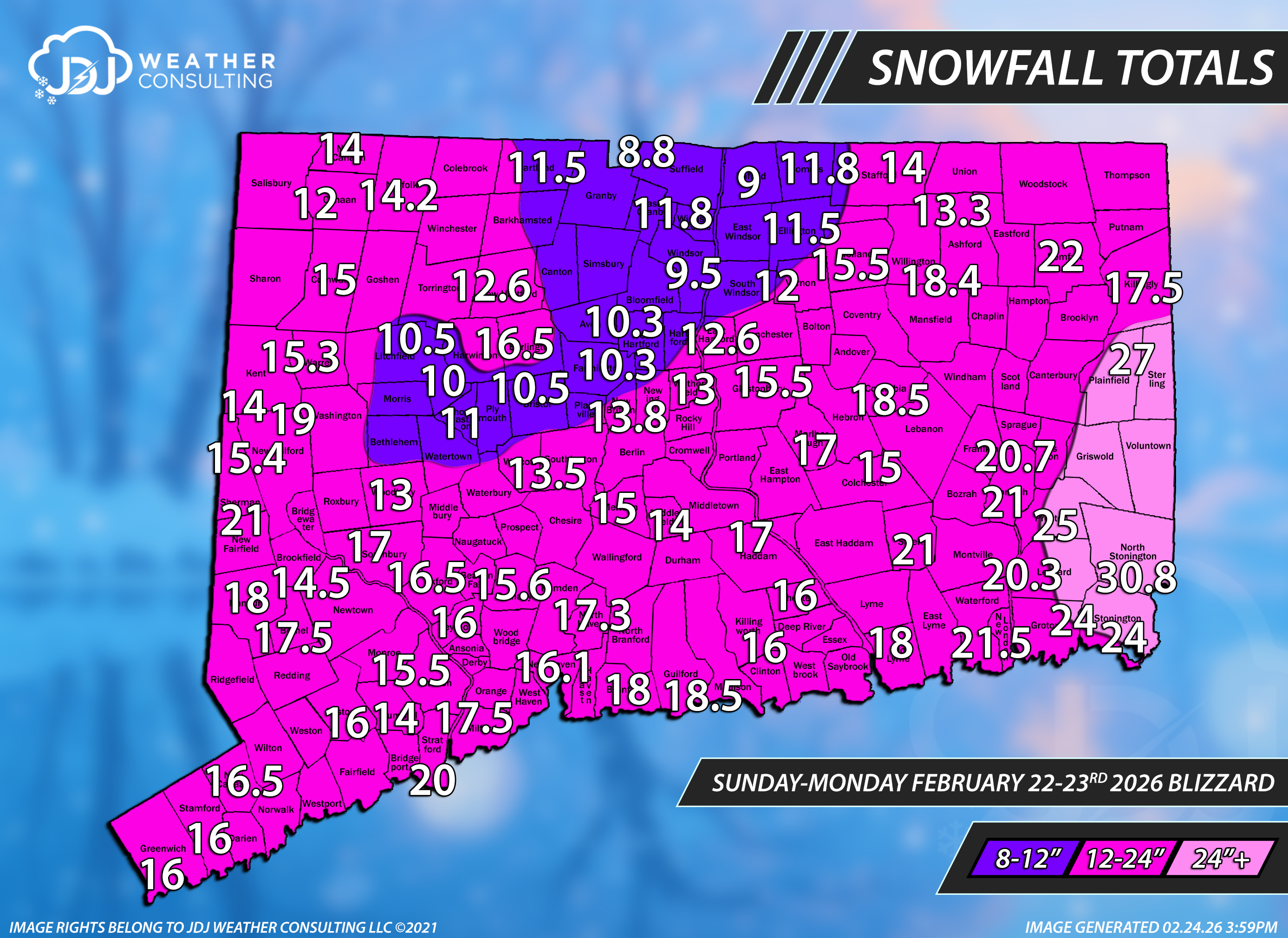
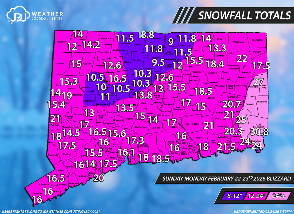
This is a first pass - initial snowfall totals for CT only. Will be working on SNE/Tri-State for the next couple days, it's going to be quite a project to say the least. Thanks to everyone who sent reports, i tried to use most of them if i could fit them in. This CT one will get updated with different ranges but used the original ones for verification purposes. Overall feel very good about the final call forecast, at least for Connecticut. Some higher amounts greater than 2 feet occurred in SE New London and eastern Windham counties. Feeling an A- for the grade for CT.
-

Clipper Fires In Wednesday Feb 25 Disco/ Obs
WinterWolf replied to Damage In Tolland's topic in New England
Already got an email saying be ready for delays, and hopefully not closures. -
Well, Canadian gives you twice mby, Euro gives me 3.3" and you 2.4". It's really the Gfs with the great disparity, and it's fair to say, that ain't holding for 7 days this winter. Could be congrats Chill ultimately.
-
I’m even more speechless than yesterday! For Mar 7th, the mean has plunged from +20 with only 2% reversing around then a mere 5 runs ago to -11 and 100% reversing on today’s!! Again, I’ve never seen anything anywhere close to this before. Despite this, the EW run for the 3 weeks near and after Mar 7th are even milder than yesterday!
-
Clipper Fires In Wednesday Feb 25 Disco/ Obs
WinterWolf replied to Damage In Tolland's topic in New England
You’re a meteorologist …e-mail em and tell them they are wrong.