All Activity
- Past hour
-
Looks improved for the NE areas ( NE MD and Northern De )
-
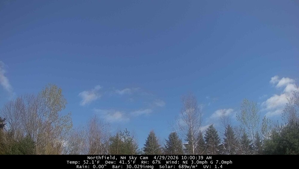
Gorgeous morning with mostly sunny skies.
-
I'm grateful to have received a little over an inch the past 3 or 4 days. It has helped the top of the ground some but the rivers and streams didn't budge and they are talking about water restrictions coming along the Catawba River basin this summer if things don't change quickly. They are already asking people to conserve voluntarily.
-
I guess the rain this morning disappearing might result in less stabilization of the atmosphere and more opportunity for storms this evening. Recent hi res modeling has been trending higher with storm coverage in areas that missed today’s morning rain
-
April 29 1984: Late season heavy snow blankets the Twin Cities with 6.6 inches. 1940: Heavy rain falls in Duluth, with a daily total of 3.25 inches. For Wednesday, April 29, 2026 1905 - The town of Taylor, in southeastern Texas, was deluged with 2.4 inches of rain in fifteen minutes. (The Weather Channel) 1910 - The temperature at Kansas City, MO, soared to 95 degrees to establish a record for the month of April. Four days earlier the afternoon high in Kansas City was 44 degrees, following a record cold morning low of 34 degrees. (The Weather Channel) (The Kansas City Weather Almanac) 1963 - A tornado, as much as 100 yards in width, touched down south of Shannon, MS. The tornado destroyed twenty-seven homes along its eighteen mile path, killing three persons. Asphalt was torn from Highway 45 and thrown hundreds of yards away. Little rain accompanied the tornado, so it was visible for miles. (The Weather Channel) 1973 - The Mississippi River reached a crest of 43.4 feet, breaking the previous record of 42 feet established in 1785. (David Ludlum) Note: Where?? LOL 1987 - A storm off the southeast coast of Massachusetts blanketed southern New England with heavy snow. Totals of three inches at Boston MA, 11 inches at Milton MA, and 17 inches at Worcester MA, were records for so late in the season. Princeton MA was buried under 25 inches of snow. (The National Weather Summary) (Storm Data) 1988 - Thunderstorms produced large hail and high winds in central Texas. Baseball size hail was reported at Nixon, and wind gusts to 70 mph were reported at Cotulla. Heavy rain in Maine caused flooding along the Pemigewassett and Ammonoosuc Rivers. (The National Weather Summary) (Storm Data) 1989 - Thunderstorms produced severe weather in Arkansas, Louisiana and eastern Texas, with more than 70 reports of large hail and damaging winds. Softball size hail was reported at Palestine TX. Hail as large as tennis balls caused ten million dollars damage around Pine Bluff AR. (The National Weather Summary) (Storm Data) 1990 - A storm system crossing northern New Mexico blanketed parts of the Rocky Mountain Region and the Northern High Plains with heavy snow, and produced blizzard conditions in central Montana. Much of southern Colorado was buried under one to three feet of snow. Pueblo tied an April record with 16.8 inches of snow in 24 hours. Strong canyon winds in New Mexico, enhanced by local showers, gusted to 65 mph at Albuquerque. Afternoon temperatures across the Great Plains Region ranged from the 20s in North Dakota to 107 degrees at Laredo TX. (The National Weather Summary) (Storm Data)
-
Was looking like 1 to maybe 2” potential in E CT, not so much today
-

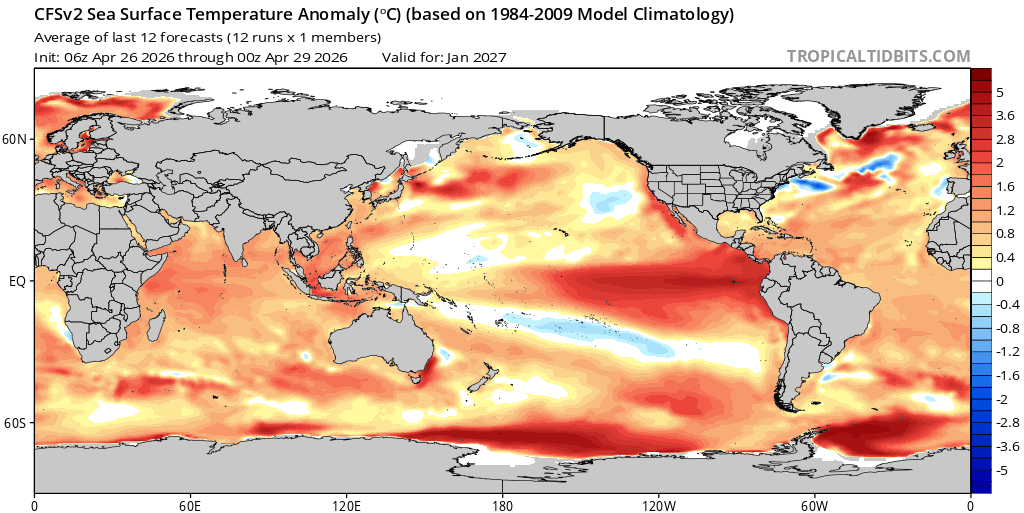
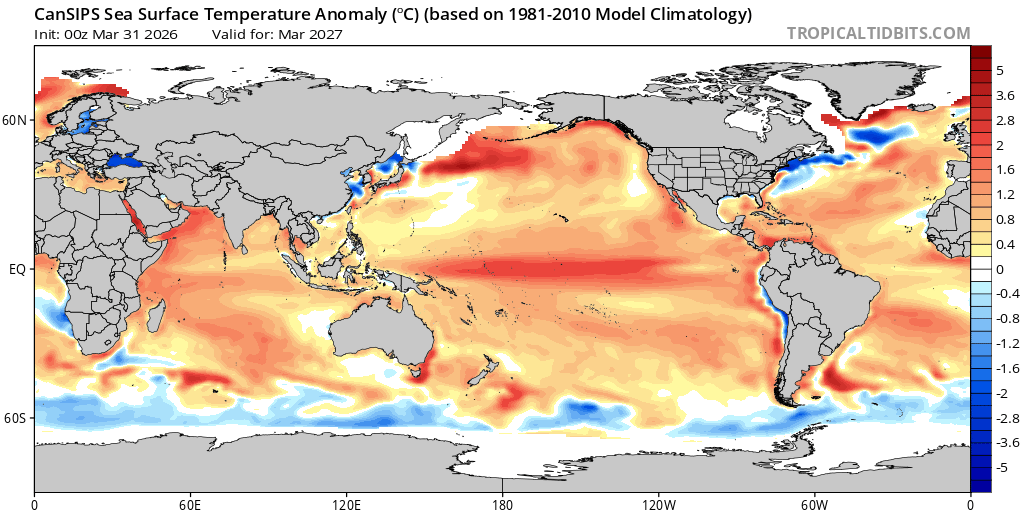
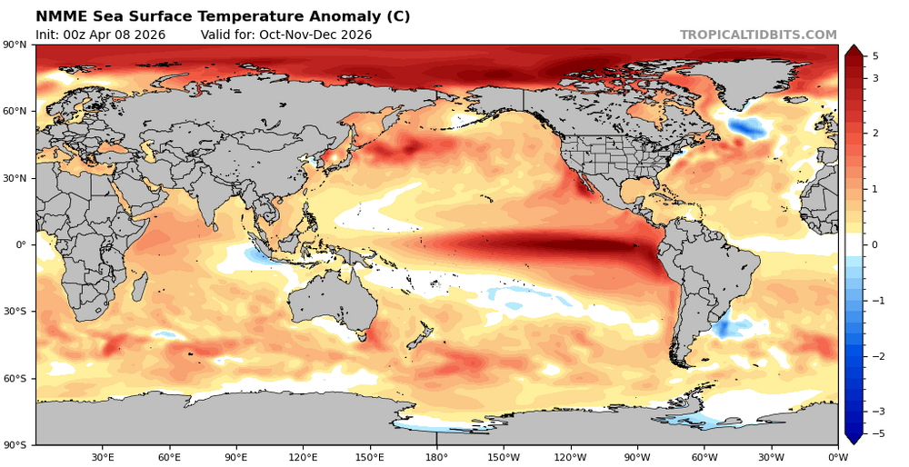
2026-2027 El Nino
40/70 Benchmark replied to Stormchaserchuck1's topic in Weather Forecasting and Discussion
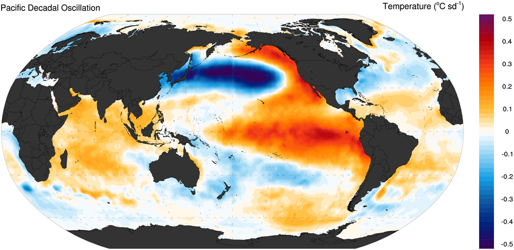
CANSIPS looks a bit more neutralish to me, since the warmth displaced northward slightly...probably in part why the model is colder in the east next winter. -
It’s funny, we were told last weekends rain was the appetizer now it + those who saw rain yesterday might be the entire “wet” period…
-
2026-2027 El Nino
40/70 Benchmark replied to Stormchaserchuck1's topic in Weather Forecasting and Discussion
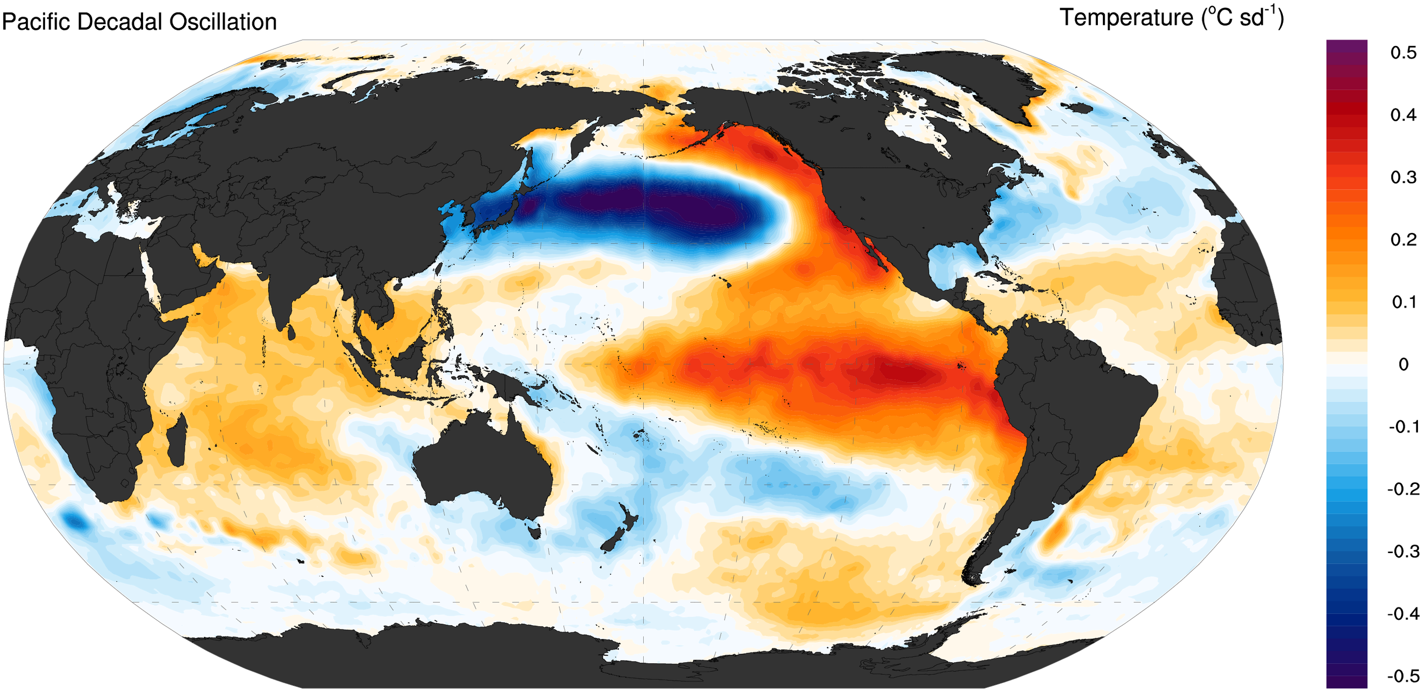
I always joke about this, but that emboldened line is the kiss of death from you. I read that, and instantly knew that the next line would be something casting doubt on the notion of a +PDO accompanying the El Nino. Haha I can't imagine this being another 2023 in terms of the PDO. I think if it remains negative, it will be marginal. Just talking about the actual DM mean index reading....not trying to imply that the winter can't still be awful for the east. -
-
zzzzzzzzzz
-
Still looks like near to perhaps AN precip next two weeks.
-
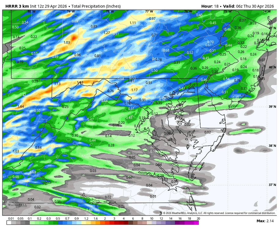
WB 12Z HRRR
-
Big rainy pattern went poof! Cooler but mainly dry-I'll take it.
-
A chance for more freezing temps this weekend.
- Today
-
Ginx has been conveniently missing from the weather disco while a chunk of NNE puts in its best string of weather days in early spring in years… Guess he passed away with those weeklies.
-
If Saturdays rain stays south mostly, next week looks pretty dry again. Too much nw flow
-
The underdog overperformed, while the “sure thing” completely fizzled without a single drop of rain. Hilarious.
-

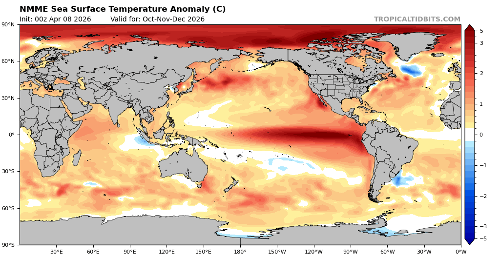
2026-2027 El Nino
bluewave replied to Stormchaserchuck1's topic in Weather Forecasting and Discussion
It will be interesting to see how things play out. But the long range models continue the warm pool east of Japan. We may have to wait until we get closer to the peak of this event to know for sure.

-
Sorry NC, I washed my truck and tuned up the motorcycle, hence the rain shifting south. I will try and do some garden work were the rain would help out and restart the drought down here so y'all have a better chance at rain.
-

Central PA Spring 2026 Discussion/Obs Thread
pawatch replied to Voyager's topic in Upstate New York/Pennsylvania
Looking at the rain map, Sellinsgrove is getting screwed -

2026-2027 El Nino
roardog replied to Stormchaserchuck1's topic in Weather Forecasting and Discussion
I still can’t believe we won’t flip to +PDO this year. It has to happen with this Nino. -
2 days left...exciting stuff
-
Could be a few warmer days especially away from western New England because a front will be lurking.
-
My dumba** took yesterday off to plant the hunt clubs dove field before the rain. What a waste


.thumb.gif.f92b16c631a1d15d405ed77b33f0710d.gif)