All Activity
- Past hour
-
Up to 14.something on the season. Well below temp avg december and a few snowfalls that made the season feel like christmas for the first time in a long time. Anyone complaining is a nutcase.
-

January 2026 regional war/obs/disco thread
ORH_wxman replied to Baroclinic Zone's topic in New England
That’s not a particularly cold pattern shown with the lower heights over AK but it’s not a torch for us either because of NAO blocking. It’s occurring during a favorable climatological period too where the averages are already pretty cold. Weeklies have been rebuilding the WPO/EPO ridge after that though which would bring more reinforcing cold air if it verified. -

Wounded Duck Strikes Back: Dec 26 & 27th Winter Storm Obs
moneypitmike replied to WxWatcher007's topic in New England
My brother in Ulster county said 15. I suspect some slant sticking. But who knows. -
Records: Highs: EWR: 63 (1949) NYC: 63 (1949) LGA: 63 (1949) JFK: 63 (2015) Lows: EWR: 3 (1948) NYC: 6 (1872) LGA: 9 (1989) JFK: 8 (1948) Historical: 1869 - A post Christmas storm in New York and Vermont produced record storm totals of 30 inches at Burlington, VT, and 39 inches at Montpelier VT. A public emergency was declared in Vermont. (David Ludlum) 1892 - An Atlantic coast storm produced a record 18.6 inches of snow at Norfolk, VA, including 17.7 inches in 24 hours. The storm also produced 9.5 inches of snow at Raleigh NC, and brought snow to northern Florida for the first time in 35 years. (26th- 28th) (The Weather Channel) 1933: A cold arctic air mass brought record cold from the Midwest to parts of the East. Locations that reported record low temperatures included: Rochester, MN: -30 °F, Waterloo, IA: -28 °F, Mobridge, SD: -19 °F, Dubuque, IA: -18 °F, Rockford, IL: -16 °F, Ste. St. Marie, MI: -15 °F-Tied, Mansfield, OH: -8 °F-Tied, Youngstown, OH: 0 °F, Akron, OH: -2 °F and Newark, NJ: 5 °F. (Ref. Wilson Wx. History ) 1948: In northern Canada, the town of Resolute in the Nunavut Provence recorded their coldest December day as the temperature plunged to -50 °F. (Ref. Wilson Wx. History ) 1969: Boston, Massachusetts recorded 4.17 inches of precipitation on the 26th and 27th the greatest 24 hour precipitation total, for December. (Ref. NOAA Boston Weather Events) 1982 - The worst Louisiana rainstorm in more than 100 years came to an end. More than 18 inches fell at Vinton, LA, during the three day storm. Flooding was widespread, and property damage was estimated at 100 to 200 million dollars. President Reagan visited the state and declared ten parishes in northeastern Lousiana disaster areas. (The Weather Channel) 1987 - A winter storm produced snow and high winds in Wyoming, Colorado and Nebraska. Denver CO experienced its worst snowstorm since December 1983 as high winds gusting to 46 mph created near blizzard conditions, whipping the fifteen inch snow into drifts five feet high, and closing Stapleton Airport. Snowfall totals in the foothills southwest of Denver ranged up to 42 inches, at Intercanyon. Blizzard conditions raged across southeastern Wyoming through the day, stranding 300 holiday travelers in the tiny town of Chugwater. Heavier snowfall totals included 19 inches at La Grange WY, and 22 inches at Elsmere NE. (Storm Data) (The National Weather Summary) 1987: Today marks the end of the infamous 2-day ice storm which began as freezing rain and sleet before sunrise on Christmas Day in Oklahoma. This ice storm left parts of Oklahoma without power for over a week. Sleet prevailed across the western and northern parts of Oklahoma City, while freezing rain devastated southern and eastern parts of the metro area. Despite heavy sleet and ice accumulations of up to 2 inches, total snowfall was only a trace. 1988 - Severe thunderstorms developing along a cold front in the south central U.S. spawned a dozen tornadoes in Mississippi between early afternoon and sunrise the following day. A tornado at Harperville destroyed five chicken homes killing thousands of chickens. Strong thunderstorm winds gusted to 80 mph at Rolling Fork MS. (The National Weather Summary) (Storm Data) 1989 - Half a dozen cities in the northeastern U.S. reported record low temperatures for the date, including Elkins, WV, with a reading of 13 degrees below zero. Watertown NY was the cold spot in the nation with a morning low of 37 degrees below zero. (Storm Data) (The National Weather Summary) 2000: Amarillo, TX was buried under 20 inches of snow in a 2-day snowstorm. (Ref. Wilson Wx. History ) 2004 - A major storm system affected parts of the western United States during December 27-29, bringing a variety of weather conditions to the region. Heavy rainfall broke daily precipitation records at some locations in California. Very heavy snow fell across the Sierra Nevada Mountains, with some areas receiving several feet of accumulation. Winds with this weather system gusted over 65 mph at some coastal and mountain locations in California. 2010: December Nor'easter- The Nor'easter on December 26 - 27 dumped 10-20 inches of snow from North Carolina to New England, stranding thousands of holiday air travelers. This was the fourth major snowstorm to affect the region this year.
-
Who wants to start the January thread?
-

Central PA Winter 25/26 Discussion and Obs
Blizzard92 replied to MAG5035's topic in Upstate New York/Pennsylvania
Just finished taking a walk and there was a very light dusting of snow on top of the sleet/freezing rain. -

Wounded Duck Strikes Back: Dec 26 & 27th Winter Storm Obs
Baroclinic Zone replied to WxWatcher007's topic in New England
Still some light OES flurries here. -

Wounded Duck Strikes Back: Dec 26 & 27th Winter Storm Obs
Ginx snewx replied to WxWatcher007's topic in New England
14 to 1 here for my 4 inches .29w/e -

December 2025 regional war/obs/disco thread
Typhoon Tip replied to Torch Tiger's topic in New England
the indexes are loading the 7th thru the 12th of January, which is well matched with both experience based, as well as recent a-priori on pattern modulation In terms of standard confidence for this range? above normal for +PNA related event(s) -
January 2026 regional war/obs/disco thread
Baroclinic Zone replied to Baroclinic Zone's topic in New England
Upcoming cutter sort of sets the stage for our new years potential. Storm sets of confluence to our north not allowing system to cut west. I see it as a clipper right now unless the upcoming storm retrogrades fast enough to to allow heights to build ahead of clipper. -
"Everything you always wanted in a snowstorm, and LESS!"
-

Wounded Duck Strikes Back: Dec 26 & 27th Winter Storm Obs
dendrite replied to WxWatcher007's topic in New England
1.0”/0.08” Enough to cover the turkey shit. -
January 2026 regional war/obs/disco thread
ORH_wxman replied to Baroclinic Zone's topic in New England
Pretty decent pattern as we go into early January. This is a 5 day mean from EPS….note how all the lower heights are now down south. Going to be more receptive to potential coastal storms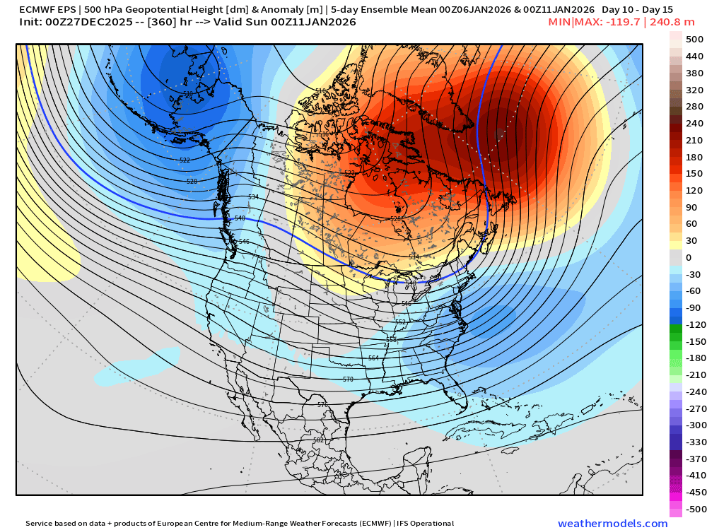
-
What a clown.
-
4.6” just measured and submitted to NWS. 12.2” for the month, can’t complain one bit.
-
So all that whining and nyc has had one of the better decembers in the last 15 or so years. Some of you need to lower expectations. Or move to old forge.
-

Wounded Duck Strikes Back: Dec 26 & 27th Winter Storm Obs
FXWX replied to WxWatcher007's topic in New England
My DOT guy is out measuring around town now... Indicating there could be more 10's than 8's. My specific location is a bear to measure; even with only a modest wind like last night, I get lots variability across my property. -
Light snow falling. 17.0F Measured 3.2"
-
I’ll take a miller lite this point
-
If we just need things to worry about(other than latitude and elevation), the cold source in Canada is less w/ overnight runs. That means we have to score w/ Canadian and not Arctic air. Thankfully, we are talking January and not mid Feb. The STJ was a bit more active overnight, but a dry pattern would be still on the table I think. The 6z GFS put 4-6" of snow over most of E TN w/ the exception of SE sections. The mountains got nearly 3 feet on that run.
-
You don’t usually see widespread “clear air busts” anymore these days. These types of cases where a small sector of the impact region gets screwed is more common vs the entire storm taking a track 100 miles off at the last second
-
Interesting to see if that works out. Pattern does have potential heading forward
-

Wounded Duck Strikes Back: Dec 26 & 27th Winter Storm Obs
WxWatcher007 replied to WxWatcher007's topic in New England
Great December for BDR -
What I’d give for a good old fashioned Miller A.
-

Central PA Winter 25/26 Discussion and Obs
Blizzard of 93 replied to MAG5035's topic in Upstate New York/Pennsylvania
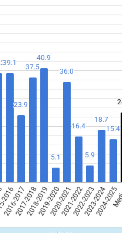
ABC-27 just showed on their news some information in regard to our local Winter weather. They had a graphic that said 8 of the last 10 Winters had below normal snowfall. I’m assuming they are using MDT stats. CTP is showing that only 6 of the last 10 Winter seasons had below normal snow at MDT. Maybe they are only using Dec to Feb which could skew it by not including November & March/April snow? Below are the official seasonal numbers from CTP’s website for MDT seasonal snow for the last 10 seasons.