All Activity
- Past hour
-
You know this reminds me ... I was just reading an article at phys.org ( paraphrasing site for deeper dive science papers ) that shows CC precipitation distribution is doing two aspect concurrently. Water boarding where it rains within an inch of gasping rates, while simultaneously ...everyone is getting drier ( on land of course..) and the general layout. Intuitively this is probably more true in the interior of continents than it is around the seagull's range from the coasts. Anyway, what you described fits how a location might express the same. I guess wait until you get a slow mover in late June and the babbling creek under the street down the way suddenly flows over the road, scouring it completely away off a weather forecast for isolated thunder but primarily just partly sunny warm, high of 87
-
You're too young to have experienced the 1960s.
-
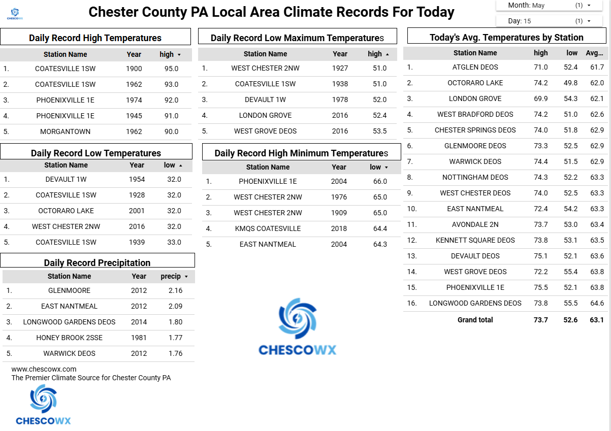
We're far enough from salt water to avoid significant marine influence. However, with a warming climate one might expect more convective events, but the opposite has been occurring. Our average for thunder days is 15 but in recent years it's been lower, and just 5 days last year, only the 2nd year below double digits (8 in 2010). Met summer had only 2 instead of the average of 10. Merely stochastic variation? (SSS - we moved here 28 years ago on May 15.) Had 1.28" between 9 last evening and 7:30 this AM, a very pleasant surprise given the modest forecast yesterday afternoon. With that drink, the coming 70s should bring an explosion of growth - leaf out here is a bit behind the average.
-
WAD
-
Back dat azz up
-
(002).thumb.png.6e3d9d46bca5fe41aab7a74871dd8af8.png)
Central PA Spring 2026 Discussion/Obs Thread
ChescoWx replied to Voyager's topic in Upstate New York/Pennsylvania
16 of our last 20 days have featured below average temperatures. Today will be another below average day before we start a strong warmup with temperatures by Tuesday approaching 90 degrees across especially the valley locations across the County. A cold front will cross the area later Wednesday with a chance of some showers. Following that front we should see temperatures fall back closer to normal levels by the end of next week.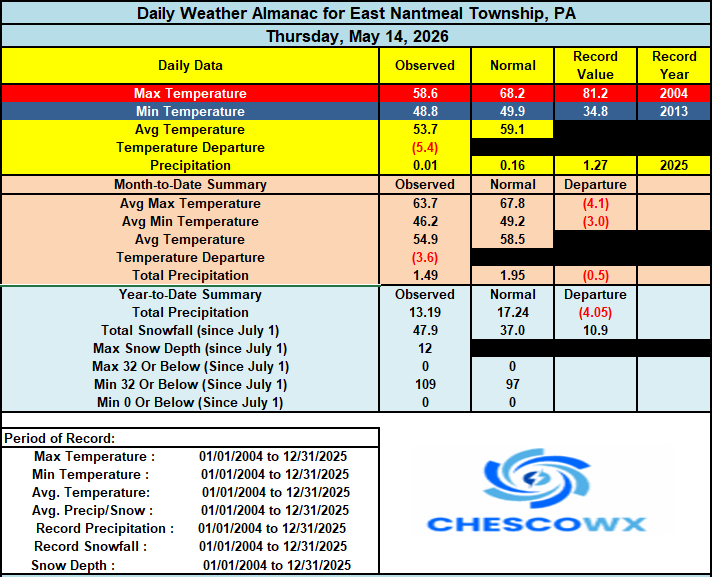

-
E PA/NJ/DE Spring 2026 Obs/Discussion
ChescoWx replied to PhiEaglesfan712's topic in Philadelphia Region
16 of our last 20 days have featured below average temperatures. Today will be another below average day before we start a strong warmup with temperatures by Tuesday approaching 90 degrees across especially the valley locations across the County. A cold front will cross the area later Wednesday with a chance of some showers. Following that front we should see temperatures fall back closer to normal levels by the end of next week.
-

2026-2027 Strong/Super El Nino
GaWx replied to Stormchaserchuck1's topic in Weather Forecasting and Discussion
My educated guess is that the current/daily RONI equivalent is ~+0.5 although like the ONI it is always moving, of course. -
Bought this place Apr 06…moved in Jun 06. Road washed out in between.
-
Yep that is life
-

Central PA Spring 2026 Discussion/Obs Thread
pasnownut replied to Voyager's topic in Upstate New York/Pennsylvania
good luck w/ the crops. Sounds like later is better for your garden. Happy planting. We gave up on our garden a couple years ago. I/we miss the "fruits of the labor, but it was my wifes hobby, and i was just the weed guy. I hate pullin weeds....lol. She just does small batch stuff in some of our larger beds. Jalapenos going in very soon she says. Her pepper jam is a crowd pleaser, just like her horseradish used to be. Have a good weekend all. -
yes it was! And I don't have any faith in seasonal outlooks so you've manage to penetrate my cynical lead on this one. Ha... I nailed the first 1/2 of winter; didn't do so good in the 2nd. Having said that, I also did not formalize any outlook so ... heh. I guess it doesn't count. Maybe if I had put the time in I might have thought differently about the back half but I bet I would have had trouble getting out of my own way. See, for NINA-decaying springs - according to my own linear eval of correlations of other ENSO of past vs the cosmic dildo - there's an interesting 2ndary offset mode for bombastically warm AMJ. As 2ndary implies, it's not the leading mode. But there's a cluster. So they don't always happen, but the ones that did went impressively warm. I felt 'hot' on the dice roll. I took a rather quick and glib gamble that CC would team up and weight the die - this could be one of those years to see an early spring. And for those of us that covet bombastically decisive endings and warm flips ...yay. Didn't really pan out. But here's the funny thing... as an after thought, CC is fucking up the analysis, anyway. See, we keep cooking up positive anomalies in the relative comparisons of just about everything. That makes is hard to parse out what is happening because of what. Example, March and April we regionally were above normal relative to climate... during a colder pattern construct. Oops. We did however bottom of the barrel below the results relative to the whole U.S., so pattern still expressed. It's like we have parallel processes going on.
-
Yeah, Islip is only ranked 13th warmest this spring for average high temperature due to the strong onshore flow influence. Areas to the west of the sea breeze are the top 5 for spring warmth. So next week looks like more of the same theme. Time Series Summary for ISLIP-LI MACARTHUR AP, NY Average Max Temp Mar 1 to May 14 Click column heading to sort ascending, click again to sort descending. 1 2010-05-14 60.5 0 2 2025-05-14 60.0 0 - 2012-05-14 60.0 0 3 2023-05-14 58.5 0 4 1991-05-14 58.1 0 5 2021-05-14 57.8 0 - 1999-05-14 57.8 0 6 2024-05-14 57.6 0 - 1977-05-14 57.6 0 - 1976-05-14 57.6 0 7 2002-05-14 57.5 0 8 2000-05-14 57.4 0 9 2016-05-14 57.1 0 10 1973-05-14 57.0 0 11 1985-05-14 56.9 0 12 2022-05-14 56.7 0 13 2026-05-14 56.4 0 14 2008-05-14 56.3 0 15 2006-05-14 56.2 0 - 1974-05-14 56.2 0 Time Series Summary for SUSSEX AIRPORT, NJ Click column heading to sort ascending, click again to sort descending. 1 2012-05-14 62.7 0 2 2025-05-14 62.4 0 3 2010-05-14 62.3 0 4 2026-05-14 61.5 0 5 2023-05-14 60.3 0 6 2024-05-14 60.2 0 7 2021-05-14 59.4 0 8 2016-05-14 59.3 0 9 2006-05-14 58.5 0 10 2004-05-14 58.1 0 Time Series Summary for PHILADELPHIA/MT. HOLLY WFO, NJ Click column heading to sort ascending, click again to sort descending. 1 2010-05-14 64.6 0 2 2025-05-14 64.5 0 3 2012-05-14 63.9 0 4 2026-05-14 63.8 0 5 2000-05-14 63.4 0 6 2002-05-14 62.5 0 7 2006-05-14 62.2 0 8 2024-05-14 62.1 0 9 2023-05-14 61.8 0 10 2021-05-14 61.6 0
-
1.11" yesterday and 0.05" from midnight through now.
-
8 years ago. Wild day for SW CT. Thankfully I outran it and missed driving through it coming home.

-

2026-2027 Strong/Super El Nino
Stormchaserchuck1 replied to Stormchaserchuck1's topic in Weather Forecasting and Discussion
Daily RONI is still below Weak Nino threshold of +0.5? Only 1991 had a May RONI +0.5 to become a Super Nino, all the others were averaging ~+0.8 by now. -

2026-2027 Strong/Super El Nino
40/70 Benchmark replied to Stormchaserchuck1's topic in Weather Forecasting and Discussion
Only issue is that the RONI ls lagging the ONI by more this go-around, even though it is like to reach or exceed that absolute value of 1982. -
34 at 6:30. Frost and 30 at Headwaters.
- Today
-
For my location, both models are showing more snow than I care to see, and it has been consistent enough that I am starting to pay attention. I have a lot of trees and my cottonwoods are leafed out now. Rain would be fantastic…
-
The word drought and New England should never be used in the same sentence.
-
And then in a few months when its 90 degrees at 10am we will be complaining for this type of weather
-
Right but relative to the normal temps it was more extreme. Naturally, dewpoints are going to increase as we approach June.
-
Jones Beach water temp is still 52-53. That’ll put a hard stop on any temp climb on the south shore with that kind of S wind. Probably a full on Ambrose Jet day or two thrown in. Even here might be hard to get much above 80.
-
Dep through May 14 first two weeks of the month, should erase this in a weeks time and see + dep by the 21 Almost to the halfway point NYC: -2.2 LGA: -2.1 JFK: -1.1 EWR: -0.9
-

Central PA Spring 2026 Discussion/Obs Thread
Superstorm replied to Voyager's topic in Upstate New York/Pennsylvania
Depending on thunderstorms in the summer to make up the drought is a crap shoot. I fear this gets much worse.