All Activity
- Past hour
-

Richmond Metro/Hampton Roads Area Discussion
ORFDawg2013 replied to RIC Airport's topic in Mid Atlantic
Didn't go into today with much expectations, and pleasantly surprised at what happened, all things considered. Would have liked a legit storm with heavy accumulations, but we did get spoiled a lot last winter. -

Central PA Winter 25/26 Discussion and Obs
Mshaffer526 replied to MAG5035's topic in Upstate New York/Pennsylvania
About 2.25" in Gap. Are we about done soon out this way? Seems like heavier returns from the pivot are Chesco on east -
Luck of the draw but I'm in JC and its still dumping here so IDK how bad that subsidence zone really is.
-
Uncharted for the models algorithms. That is all. Half-full OR Half-empty? Could be an attempt depicting a capture and stall. The haves are going to continue to have and banding features becoming clearer.
-
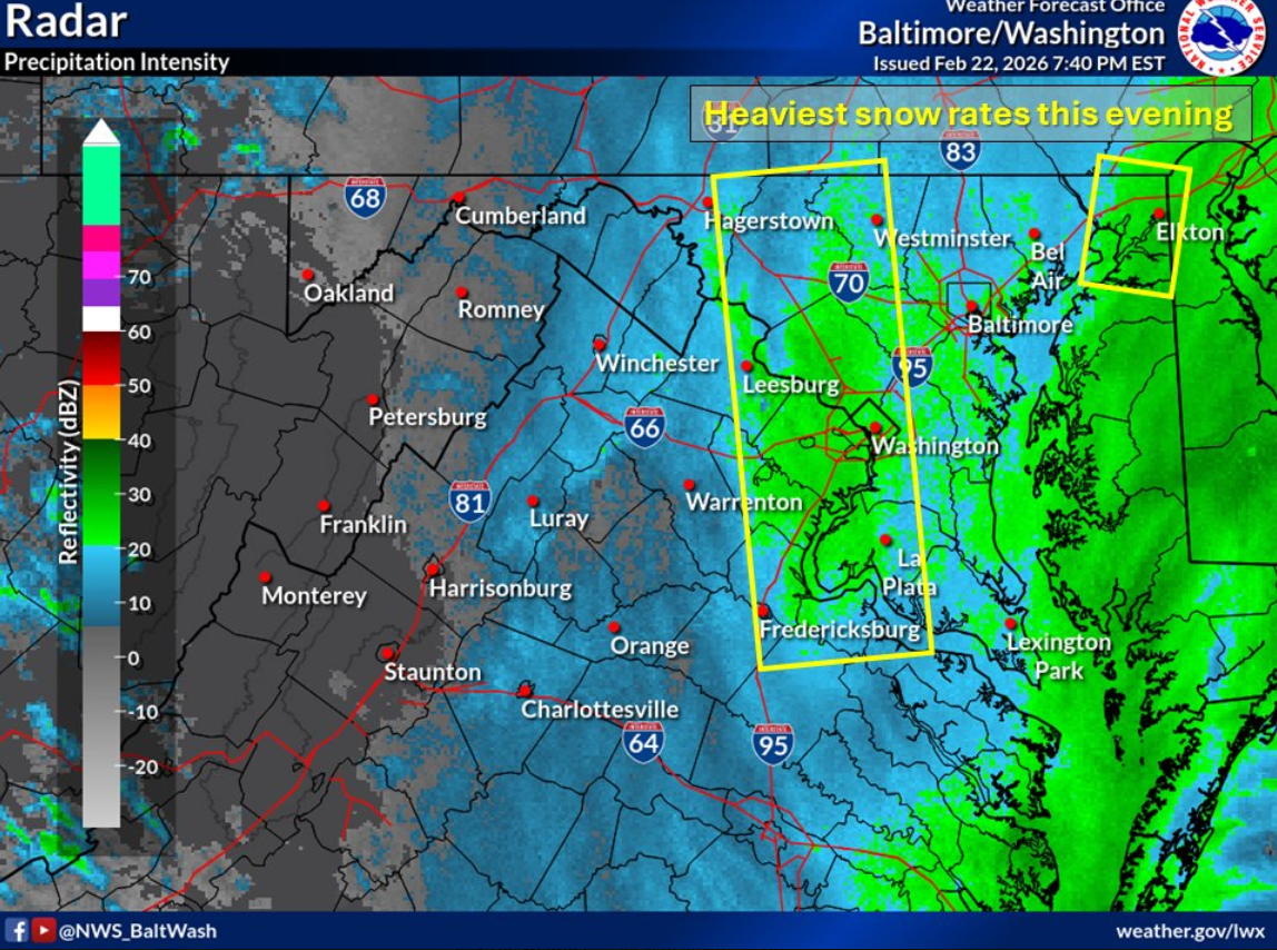
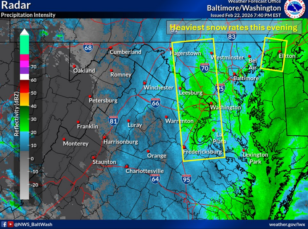
there's isolated t-snow fyi, just got a report from central maryland
-
changeover from kokomo to margaritaville impending
-

"Don’t do it" 2026 Blizzard obs, updates and pictures.
WxWatcher007 replied to Ginx snewx's topic in New England
-
It’s killing me to be here. All the New Yorkers at this conference looking at their nest cams.
-
It looks like the main inv trof band is the eastern one.
-

Feb 22nd/23rd "There's no way..." Obs Thread
winter_warlock replied to Maestrobjwa's topic in Mid Atlantic
It's only February dude. Still got March to get thru -

"Don’t do it" 2026 Blizzard obs, updates and pictures.
Sey-Mour Snow replied to Ginx snewx's topic in New England
already widespread 5-7" in long island from that band -

Blizzard of 2026 Storm Thread/OBS
anthonyweather replied to Mikeymac5306's topic in Philadelphia Region
Southern Lehigh County and Philly about to get smoked . -
The bands are incoming slowly. We are getting wrecked up here in the bx in a band within a band but when that li weenie band lifts in to nyc you'll get it too.
-

Feb 22nd/23rd "There's no way..." Obs Thread
peribonca replied to Maestrobjwa's topic in Mid Atlantic
Getting into a bit of the norlun in Colonial Beach. Rates picked up, rates 1-1.5/h and roads caved. I loved getting norluned! -

"Don’t do it" 2026 Blizzard obs, updates and pictures.
Typhoon Tip replied to Ginx snewx's topic in New England
I think some of this north of that main three level green band down there might be a little bit enhanced by the ocean because these echoes seem to be moving west north west while the band down there is slowly inching north up underneath and as it comes north it just overwhelms everything -

"Don’t do it" 2026 Blizzard obs, updates and pictures.
40/70 Benchmark replied to Ginx snewx's topic in New England
The modeling lead up is akin to the regular season....those spots, along with RI and SE MA just won 107 games and look great, but the post season is about to start.....just get into the dance, and sometimes the 83-win WC team takes home the trophy. -
The issue is your Christmas lights are still up and lit.
-
I left ACY a while back. Heading home now, roads are treacherous.
-
Since we lost Fridays 6z Nam nuke this was going to be a non event. Can’t expect accumulations with temps 34-35 degrees and above freezing ground. Nonetheless was a decent one to track.
-

Pittsburgh/Western PA WINTER ‘25/‘26
colonel717 replied to Burghblizz's topic in Upstate New York/Pennsylvania
I have never seen one of them come to fruition when it says slight risk. The storm today had moderate or high risk for coast areas when it first came out. -

“Cory’s in NYC! Let’s HECS!” Feb. 22-24 Disco
Go Kart Mozart replied to TheSnowman's topic in New England
Is LI about to get slotted? -
Stay safe!
-

Feb 22nd/23rd "There's no way..." Obs Thread
SnowenOutThere replied to Maestrobjwa's topic in Mid Atlantic
The western and intensifying band is exactly 2 miles to my west. Still getting some good blowing snow but nothing crazy like it was from the 5-7pm hours. Hoping it slowly shifts east to get me in the goods. Either way not going to worry about it and hop on into the hot tub for a bit. -
Huge band off the water about to come into southern sections of NYC.
-
Looks like the sharp cutoff will be near the Warren County line in NJ. Near Clinton.