All Activity
- Past hour
-
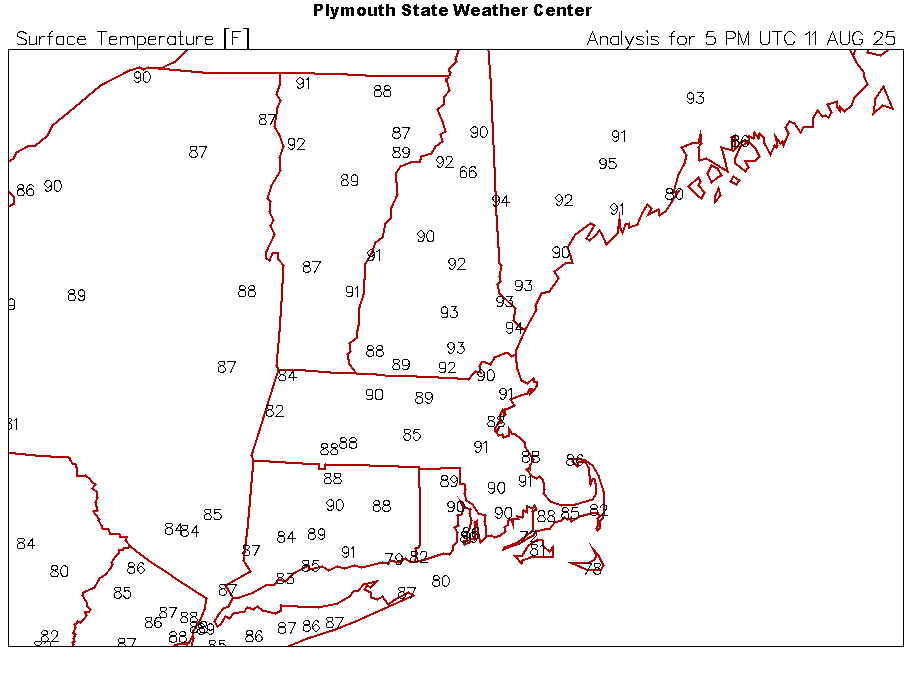
Hit 95F here. Leaving the AC off for the moment but expect we may want it tonight.
-
88F IMBY. 90 possible
-
MVL melted.
-
Wow, 95F at Augusta, Maine!
-
Warm
-
Gwdlt 87*57* HI87* top ten summer day
-
Where’s the impetus to drive it NNW up the coast?
-
At least my grass will be green until fall
-
I’m still logging insurance claims from CMC output.
-

Central PA Summer 2025
TheClimateChanger replied to Voyager's topic in Upstate New York/Pennsylvania
That was @canderson post. I haven't posted in here in a while, specifically because of the trolling. -
I asked that as a joke because Ray said it would set you off. They make the same forecast every year...let's root for broken clock theory.
-
Central PA Summer 2025
TheClimateChanger replied to Voyager's topic in Upstate New York/Pennsylvania
I'm not. @pasnownutwas giving me a hardtime about not posting the record lows, so I just quoted them to point out they were already posted. -
Looks like might’ve been a little solar contamination earlier, 92.2 in the shade. Still pretty freaking hot.
-
There is zero wind today. You can tell me about lower dews and Sun angle all you want, it feels like one of the hotter days of the year.
-
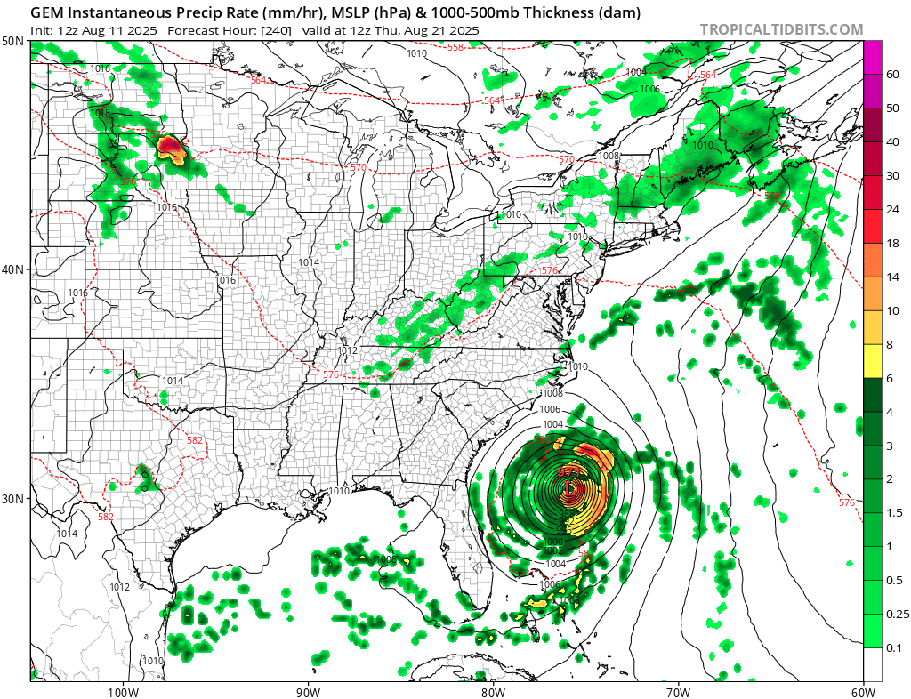
Cmc much closer to coast
-
I mean it's relative because 850 Ts climo are cooler on 8/20 vs 7/20. But doesn't seem like a Fall crisp shot.
-
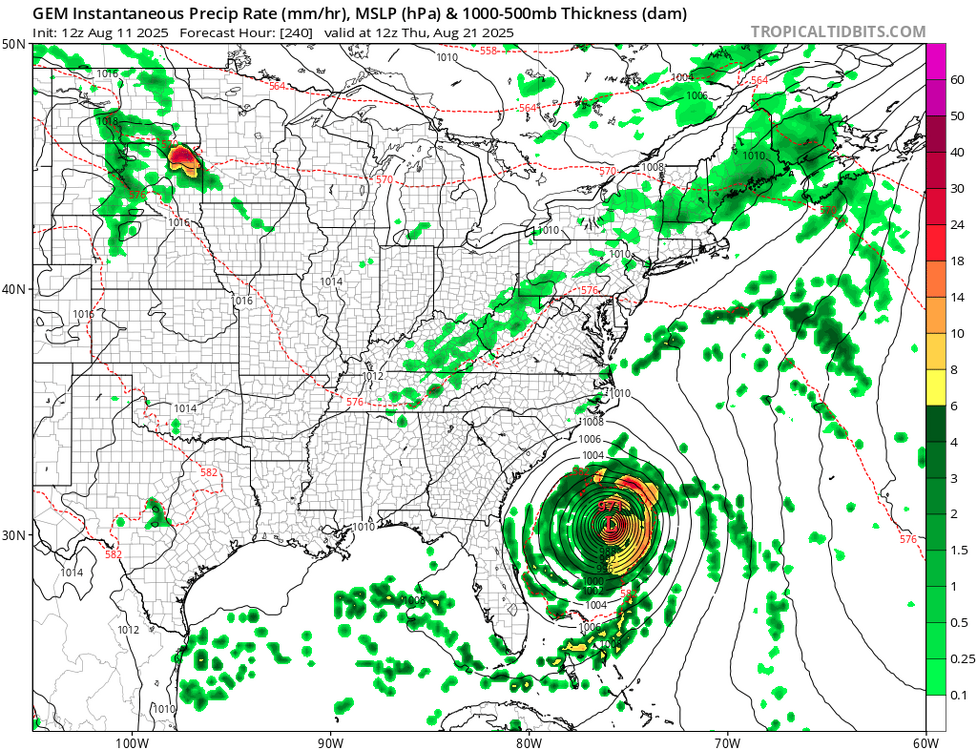
Cmc very close to the coast

-
sent you a PM about school. I'd say go for it
-
That’s what we trying to explain to Raymond Spinazola
-
84/66 at 12:45pm. Dews are up about 10 degrees since last evening. Starting to feel more uncomfortable but nothing like what we went through in July.
-
Eastern Valley has more chances to get rain especially Tuesday. Not everyone got it the past 7 days but more chances are coming. I'm happy the Eastern Valley heat got pushed back a few more days. With any amount of luck the heat this weekend, book-ended by similar weekdays, could be the last of the worst of summer. Depending on how any tropical cyclone behaves the heat ridge could either be augmented or chipped at. Either way prolly a few hot days here. Toward the end of August we might be able to trim dewpoints even temps creep back up. Late August fronts don't help temps much past 1-2 days* but they and chip away at dews. Either way the sun angle gets noticaby lower which takes the edge off midday too. Late August sun angle is the same as mid-April. LOL the temps part! *Apparently early August fronts set record low maxes though.
-
12Z UKMET: further W than the 0Z’s recurve at 63.3W with a threat to Bermuda as it ends the run moving NNW: NEW TROPICAL CYCLONE FORECAST TO DEVELOP AFTER 24 HOURS FORECAST POSITION AT T+ 24 : 17.8N 35.1W LEAD CENTRAL MAXIMUM WIND VERIFYING TIME TIME POSITION PRESSURE (MB) SPEED (KNOTS) -------------- ---- -------- ------------- ------------- 1200UTC 12.08.2025 24 17.8N 35.1W 1008 30 0000UTC 13.08.2025 36 17.3N 39.1W 1007 30 1200UTC 13.08.2025 48 17.1N 42.2W 1006 28 0000UTC 14.08.2025 60 17.8N 44.6W 1007 29 1200UTC 14.08.2025 72 19.4N 48.1W 1007 32 0000UTC 15.08.2025 84 20.8N 51.7W 1008 31 1200UTC 15.08.2025 96 21.4N 55.0W 1007 30 0000UTC 16.08.2025 108 22.0N 57.9W 1006 34 1200UTC 16.08.2025 120 22.3N 60.2W 1003 43 0000UTC 17.08.2025 132 23.4N 62.8W 1002 44 1200UTC 17.08.2025 144 25.0N 64.3W 1001 47 0000UTC 18.08.2025 156 26.0N 65.4W 999 45 1200UTC 18.08.2025 168 27.5N 66.0W 998 50
-
Definitely straight up hot out there today.
-
Sad to hear that but congrats on grad school! I still kick around the idea of going back for a met degree but I think that ship has sailed. Maybe some sort of a certificate though to enhance my forecasting knowledge.
-
fyp