All Activity
- Past hour
-
Yes, this is very reminiscent of the winter weather pattern we had last January and last February, which mainly has suppressed storms that targeted the southern US and areas of the lower Midwest, while most of the rest of the country was cold and dry. With this next push of arctic air there simply isn’t enough of a southern stream to coincide with the arctic air and produce much meaningful snow. Instead, we are stuck with the winter pattern from last year, which is dry, cold, and any snow is usually suppressed.
-
 As I live and breathe, I did not buy into this post. Woke up to about 0.1" of the white stuff.
 -

2025-2026 Fall/Winter Mountain Thread
CentralNC replied to Buckethead's topic in Southeastern States
It is very early, but has a "wasting cold air" type feel to this pattern. -
The sky looks like snow in Raleigh today but of course nothing is falling.
-

December 2025 Short/Medium Range Forecast Thread
John1122 replied to John1122's topic in Tennessee Valley
We are -8 for the month, but normally you arrive there by being -16 and then normal over short periods. This has been essentially-7 to -10 each day, so nothing super cold. -

December 2025 Short/Medium Range Forecast Thread
Carvers Gap replied to John1122's topic in Tennessee Valley
I am just now catching up on overnight and afternoon modeling, so please forgive me if I am on stepping in old footprints. These are the real feel temps for the mid-month cold front. The GFS I "think" had this on d16 of its run a few days ago. It is now well within d10. The 12z EPS is the colder of all the ensembles, and that gets my attention w/ its usual warm bias. Some deterministic models don't get us above 20 degrees. This reminds me of the 09-10 setup. It got cold right as school let out - as in the very day school was dismissed for Christmas. Cars were stranded in a pretty good commuter snow storm. This could be an 83-84 deal where it gets cold and doesn't snow. I fully see that. However, I see the Euro cranking a big storm high around this time frame. Often, we will see cold temps and big snows coupled. These temps are pretty much on bare ground. The GFS gets TRI below zero(in some places) with actual temps. The thing that concerns me a bit is that the GFS has the warmest MJO!!! If it is just now catching on(and it has a habit of seeing cold shots before other models at range during December), then look out. Still time for things to change, but a big shot of cold air is growing likely but not certain. Once we get to day 6-7, I think the cold is baked in the cake...so a few more runs to go. TRI has managed -6.8F and TYS -7F(for the first six days of the month) without strong amplification. What I am seeing w/ deterministic runs is a tendency to amplify the pattern sooner than later. -

Dec 6-7th (It's not a clipper) Clipper
frostfern replied to Chicago Storm's topic in Lakes/Ohio Valley
Summer is invading winter. What happened to lake effect? -
December 2025 Short/Medium Range Forecast Thread
John1122 replied to John1122's topic in Tennessee Valley
To me, it's the shape of the ridge in the West. It's not been sharp S to N oriented so the cold hasn't been pressing south, more West to East. The GFS sharpens the Western Ridge and the cold crashes south. -
Pattern just has the feel that is something is going to pop, and without much particular warning.
-
There’s a decent signal on the 12z EPS for a chance of another Advisory type of event in the Friday/Saturday period.
-
Cold and dry seems about right.
-
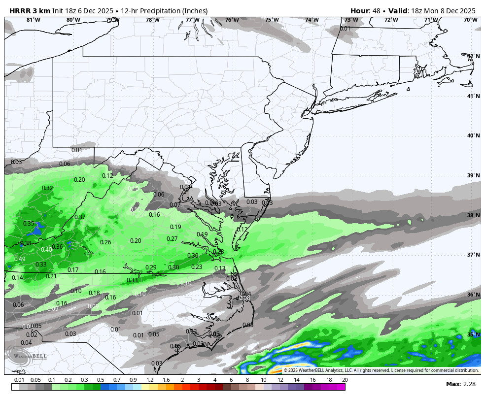
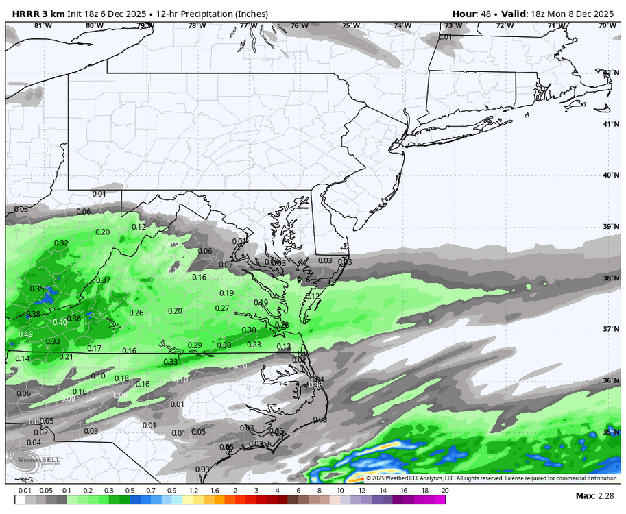
Long range HRRR is intriguing too. If I was you I’d be thinking about a 0.5” refresher course down there. See if we can get any more juice or a northern push in the next 36 hours. Ease off the confluence a little bit more…
-

Central PA Fall Discussions and Obs
Blizzard of 93 replied to ChescoWx's topic in Upstate New York/Pennsylvania
There’s a decent signal on the 12z EPS for a chance of another Advisory type of event in the Friday/Saturday period.
-
December 2025 Short/Medium Range Forecast Thread
Carvers Gap replied to John1122's topic in Tennessee Valley
The other thing I am noticing is an uptick of the mean snow total over TRI. That might be "IMBY" a bit too much, but that is usually a good thing for everyone when it goes up. The 12z AIFS-Ensemble has 2-5" of snow from TYS to SW VA. The 12z GEFS has 1-6" of snow from TYS to TRI. -
12/5: 1.5”
-
December 2025 Short/Medium Range Forecast Thread
Carvers Gap replied to John1122's topic in Tennessee Valley
I just think climatology really doesn't support super cold air until mid-December. There are lots of "whys," but I also think the MJO wasn't in the phase where the cold centers in southeastern NA. But it is MUCH colder than models had it when the SER was once modeled here w/ highs in the 70s. IMHO, modeling has tended to have a shallower trough and that has verified. The bitterly cold air I have seen modeled has been w/ the cold air masses of Dec 8th and 14th. And to the number that matters, TRI is -6.8F for the month so far. That is pretty big departure. Every day has been BN w/ a trace of snow on two of the six days. I can say this...I have been freezing my tail off while running in the mornings. I pretty much ice skated one morning on freezing fog. Pretty good start in my book. -

Mid to long range discussion- 2025
WinstonSalemArlington replied to wncsnow's topic in Southeastern States
Stout Alaskan Ridge upcoming -
12Z OP EURO is cranking out some bitter cold for late next week / weekend from the upper Mid-West / Great Lakes then into the Northeast. Big cold high drops to Iowa/Missouri by next Saturday and pushes east. OP at face value is storm squashing cold. We'll see but one thing for sure solidly below normal through mid month at least.
-
Digital Snow Thread Winter 2024-2025
WinstonSalemArlington replied to SnowenOutThere's topic in Mid Atlantic
-
Mid to long range discussion- 2025
WinstonSalemArlington replied to wncsnow's topic in Southeastern States
-
Just in time for xmas. Lock it up. Sent from my SM-S921U using Tapatalk
-
Very early in the season. Hopefully the region will score this season.
-
Mid to long range discussion- 2025
WinstonSalemArlington replied to wncsnow's topic in Southeastern States
December 15 -
Dec 6-7th (It's not a clipper) Clipper
Paulie21 replied to Chicago Storm's topic in Lakes/Ohio Valley
Pretty much all models hinting at a nice corridor of higher UVVs for northern IL tonight between 850mb - 750mb. Not perfectly co-located with the small area of DGZ but not bad at all for a couple hours of 1"+/hr rates perhaps. Not perfectly textbook case but looks like theta-e lines in the cross section are more spaced out and climbing. Perhaps some slantwise convection possible? Not a perfect setup but it does coincide with best LRs (saturated) in the sounding, strong speed shear above veering wind profile, AND weak absolute vorticity. Could really thump right before dawn.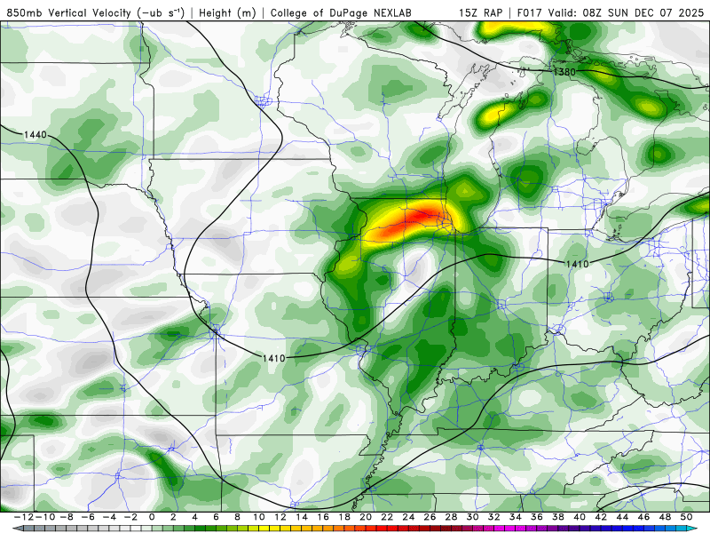
-

December 2025 regional war/obs/disco thread
AstronomyEnjoyer replied to Torch Tiger's topic in New England
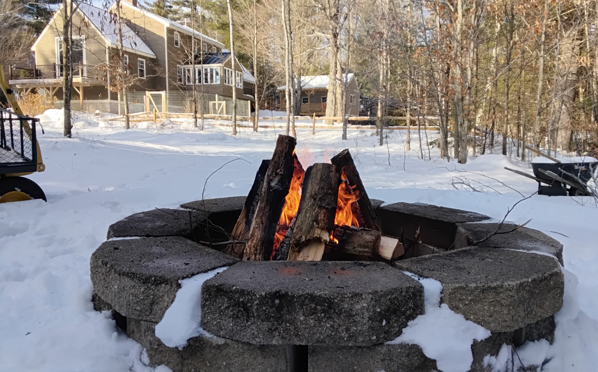
Sun came out and temp rocketed up to 37.9°. Taking advantage of the nice weather to get rid of some of the softwood that was a little too sporty for the inside fireplace.