All Activity
- Past hour
-
The snowfall data below is what I post each December for La Niña conditions using the newer RONI definition due to the warming of the global oceans. The December to seasonal snowfall relationship has worked 14 out of the last 15 times. My guess is the reason for the reliability as an early seasonal marker for below and normal to above average snowfall across the entire season is related to the La Niña seasonal progression. They tend to be more frontloaded in nature so their seasonal snowfall pattern is usually revealed early on in December. Plus in our warmer climate we have been noticing more repeating patterns perhaps related to non linear convective thresholds being met in tropical oceans driving the forcing. The relationship works for NYC, EWR, and LGA. I will post the data for NYC below which is similar to the other two stations. For the sake of this discussion I have been using 4” of snow in December as the cutoff. But it’s possible that it could actually be a little higher around 5” inches based on the available data. So it’s fine if someone else wants to use a 4-5” snowfall range for December snowfall as the cutoff line for below and normal to above normal seasonal snowfall. I am not making the argument that the December snowfall is causing the outcome of the rest of the season to change. Just that it serves as a marker to reliably expect the rest of the season. Sometimes two data points can be related due to other underlying variables that may not yet be fully sampled by our current scientific understanding. I will update this post once we have the complete December snowfall data. NYC December to seasonal snowfall during the most recent 15 La Niña seasons as defined by RONI in either the fall into winter https://www.cpc.ncep.noaa.gov/data/indices/RONI.ascii.txt 24-25….2.8”….12.9” 22-23….T……….2.3” 21-21…..0.2”……17.9” 20-21…..10.5”….38.6” 17-18……7.7”……40.9” 16-17……3.2”……30.2” the one case in the last 30 years that didn’t work out 11-12……0.0”…..7.4” 10-11…..20.1”…..61.9” 08-09…..6.0”…..27.6” 05-06…..9.7”…..40.0” 00-01…..13.4”…..35.0” 99-00…..T……….16.3” 98-99……2.0”…..12.7” 95-96…..11.5”……75.6”
-

12/14: Sunday funday? Will the south win again?
stormtracker replied to TSSN+'s topic in Mid Atlantic
lol. we get it. We need a widespread storm tho -
Sterling alluded to a "low end warning event" in their late morning AFD update.
-
I survived Icestorm 98, 2-2.50"+ of ice, That was enough for me.
-
Low of 29 and currently 44 and light graupel.
-

E PA/NJ/DE Winter 2025-26 Obs/Discussion
Wannabehippie replied to LVblizzard's topic in Philadelphia Region
January thaw? -

December 14th - Snow showers or Plowable snow?
CoastalWx replied to Sey-Mour Snow's topic in New England
A lot of those events just didn’t have the confluence that we have with this one. It would start out as a wave moving off of NC and just tickle NW each run. -

December 2025 regional war/obs/disco thread
Snowcrazed71 replied to Torch Tiger's topic in New England
No man, all would not like an ice storm Christmas. I'll drive in the snow and be fine with that. But driving in ice is a absolute no! And I would venture to guess that a lot of us travel either Christmas Eve or Christmas day. But I'll be sure to put a good word into mother nature to make sure you have a good ice storm right in your hood. -
When someone says we all would, It really means he would.
-
That was freaking ravaging.
-

December 2025 Short/Medium Range Forecast Thread
jaxjagman replied to John1122's topic in Tennessee Valley
Just saying, here in Mid Tn,during NINO'S we can have destructive ice storms compared to NINA.Its really rare in a NINO winter to not see ZR or IP fall underneath SN and not just all SN.We've had in the past I.E in the 50's and 90's some destructive ice storms in MID TN.,during a NINO,for what ever reason NINA seems to bring late season snow here that falls at night/early morning and melts during the day,this is always late into winter early spring.But i'm not saying it cant snow,its winter,just the odds are it might not happen -
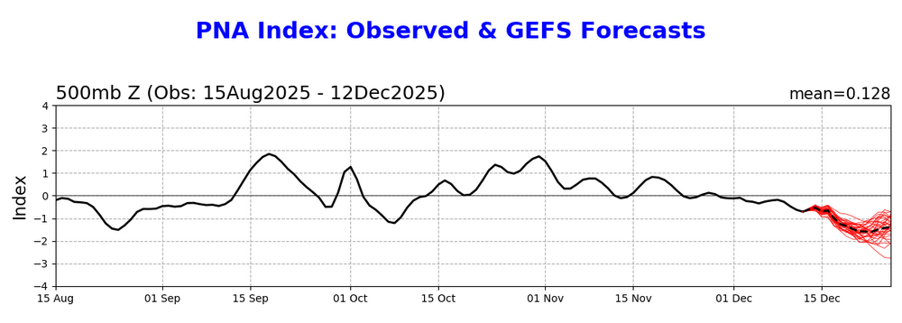
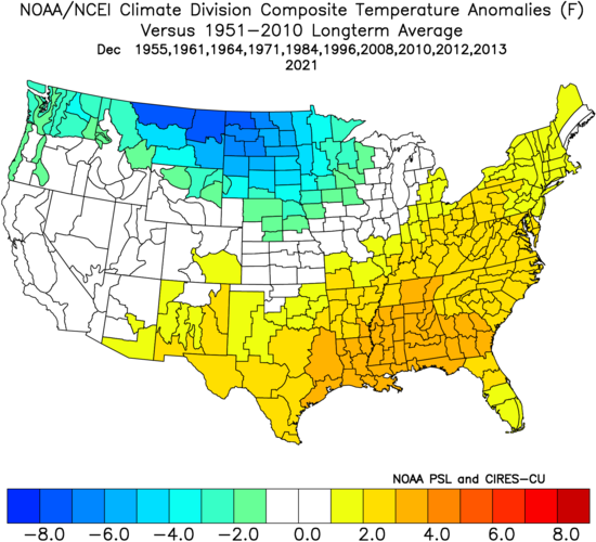
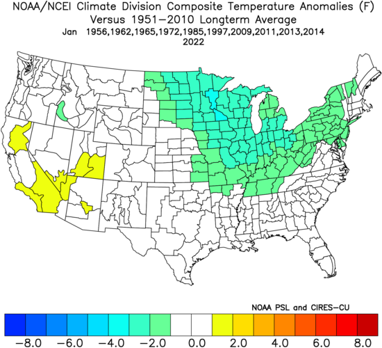
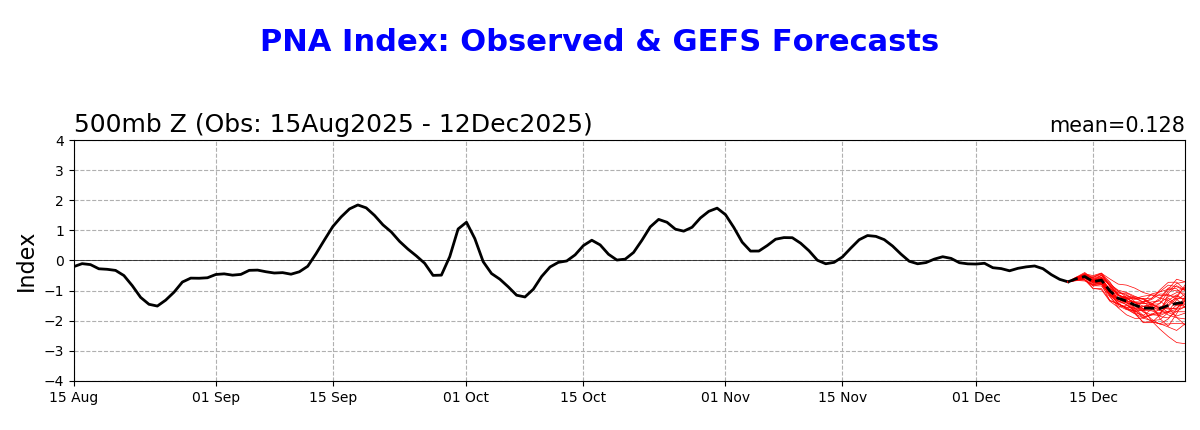
Today’s GEFS PNA forecast is the most negative for this Dec that I can recall: This implies the realistic chance for a sub -1 Dec PNA. Whereas that’s bad news for those wanting E US cold in the 2nd half of Dec in the MidAtlantic/OH Valley south, it isn’t necessarily bad news for January prospects. That’s because in the vast majority of cases for -ENSO, the PNA in January rose sharply from Dec: PNA Dec/Jan for -ENSO for strongly -PNA in Dec - 1955-6: -2.1/-1.3 (rose 0.8) - 1961-2: -1.2/-0.1 (rose 1.1) - 1964-5: -1.7/-0.2 (rose 1.5) - 1971-2: -1.5/-1.4 (rose 0.1) - 1984-5: -1.6/+1.6 (rose 3.2) - 1996-7: -1.2/+0.6 (rose 1.8) - 2008-9: -1.4/+0.6 (rose 2.0) - 2010-1: -1.8/+1.3 (rose 3.1) - 2012-3: -1.0/+0.6 (rose 1.6) - 2013-4: -0.9/+1.0 (rose 1.9) - 2021-2: -1.6/+1.0 (rose 2.6) So, average PNA rise Dec to Jan for these was a whopping 1.8! Dec temperature anomalies: coldest N Rockies to N Plains/mild much of SE 1/3: Jan temp. anomalies: coldest shifts 1,000 miles SE and warmth gone https://www.cpc.ncep.noaa.gov/products/precip/CWlink/pna/norm.pna.monthly.b5001.current.ascii.table
-
(002).thumb.png.6e3d9d46bca5fe41aab7a74871dd8af8.png)
Saturday night/Sunday 12/13-12/14 Jawn
ChescoWx replied to Ralph Wiggum's topic in Philadelphia Region
-
NBM/SREF adjustments it looks like. Those are the only things that got drier to my knowledge.
-

Minor snow possible sunday 12/14/25
wthrmn654 replied to WeatherGeek2025's topic in New York City Metro
I'm hungry, what can I say! -

December 2025 regional war/obs/disco thread
Ginx snewx replied to Torch Tiger's topic in New England
Yes some know some pretend
-
Those were absolutely rotten winters. Even the snowstorm that followed in January 2016 couldn't save the 2015-2016 winter.
-

Minor snow possible sunday 12/14/25
jm1220 replied to WeatherGeek2025's topic in New York City Metro
Pasta of Jersey... not sure I ever tried that. Tried plenty of Jersey pasta sauces -

December 2025 Short/Medium Range Forecast Thread
Carvers Gap replied to John1122's topic in Tennessee Valley
Two different models, and BIG differences for our back yards as a result. The 12z GFS has a cold front on Christmas Eve. The 12z Euro...not so much. The difference? The Euro has a much deeper area of BN heights in the eastern Pac (which originated on the NA continent...I guess that could happen but I am no holding my breath). Conversely, the GFS slides an area of BN heights over the GL(versus dumping it all into the Pac), and a strong cold front results over our region. Look at the difference in the ridge over NA. Below is a nearer term difference. This time the 12z Euro has a cold front over the East on Dec 20th. The AIFS, CMC, and ICON all have this. The GFS is the outlier. The ridge and trough locations are exactly the opposite next Friday. The GFS somehow loses energy heading East. The results are polar opposites. All of this is to say that small differences over the eastern Pacific are having huge downstream impacts. In some cases, we are seeing 50-60 degree swings in modeling. And I feel like I have typed that before...maybe later November? I do think we see some Chinook winds. That seems almost inescapable as SLPs transit the Rockies. But cold air "should" cave behind the low as it passes. Our advantage this years is that big green blob in northern Canada which recent climo had as AN heights - ie. we have a cold air source. I also think ensembles are washing things out due to the means. IF(stress) we are seeing feedback which is amping ridges in the east too much, then the average temp of all members is going to be very skewed. Things get washed out. IMO, a very back and forth, amplified pattern "could" be coming up as an alternative to the torch. If we can swing a trough through on the 20th and on Christmas Eve, that is tolerable? -

December 2025 regional war/obs/disco thread
brooklynwx99 replied to Torch Tiger's topic in New England
yeah, not really a torch pattern with the -WPO encroaching into AK and the TPV elongated like that. sure, it's a torch for 75% of the CONUS, but who cares -
December 2025 regional war/obs/disco thread
Ginx snewx replied to Torch Tiger's topic in New England
Dec 25th 1994 in the dark from a tropical storm the night before. So much fun
-
Lads lads lads. Sinceramente: how much for Philly?
-
Central PA Winter 25/26 Discussion and Obs
ChescoWx replied to MAG5035's topic in Upstate New York/Pennsylvania
By the way Timmy funny how my "improperly sited wx station" is statistically exactly the same average temperature variance over 17 full years vs KMQS a raw difference of only 0.4 degrees - also hate to break it to you but uh the latest 12z Euro has a high of 29 degrees now on Christmas Day.... -
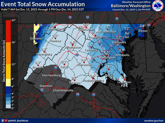
URGENT - WINTER WEATHER MESSAGE National Weather Service New York NY 139 PM EST Fri Dec 12 2025 NJZ006-106>108-NYZ072>075-078>081-176>179-130245- /O.NEW.KOKX.WW.Y.0011.251214T0300Z-251214T1800Z/ Hudson-Eastern Essex-Western Union-Eastern Union-New York (Manhattan)-Bronx-Richmond (Staten Island)-Kings (Brooklyn)- Northwest Suffolk-Northeast Suffolk-Southwest Suffolk-Southeast Suffolk-Northern Queens-Northern Nassau-Southern Queens-Southern Nassau- 139 PM EST Fri Dec 12 2025 ...WINTER WEATHER ADVISORY IN EFFECT FROM 10 PM SATURDAY TO 1 PM EST SUNDAY... * WHAT...Snow expected. Total snow accumulations between 2 and 4 inches. * WHERE...Portions of northeast New Jersey and southeast New York. * WHEN...From 10 PM Saturday to 1 PM EST Sunday. * IMPACTS...Roads, and especially bridges and overpasses, will likely become slick and hazardous.
-


.thumb.jpeg.1d2958065f007d9e7218a8c935ea8246.jpeg)


