All Activity
- Past hour
-

Central PA Winter 25/26 Discussion and Obs
pasnownut replied to MAG5035's topic in Upstate New York/Pennsylvania
Incoming snowmageddon at 348 GFS. You wanna look....ya know ya do. -
ICON looks great! Love seeing runs showing more potential!!
-

January 2026 regional war/obs/disco thread
Snowcrazed71 replied to Baroclinic Zone's topic in New England
I'm almost positive I'm going to have some remarks about this post, but I've said it before and I'll say it again, I really do like this particular guy. To me. He's not one of those social media idiots who have no clue about meteorology. This guy is the real deal. That's just my opinion. I really like what he has to say and what he's been saying for the last 2 months and he hasn't wavered yet. Again, really not worried about the comments. I'll get about this, just think it's some real good info and something to to really consider.
-
12Z GEFS shows a progressive trough moving off the coast. No big coastal storm for next week.
-

January 2026 regional war/obs/disco thread
mahk_webstah replied to Baroclinic Zone's topic in New England
Looks like there will be storms over the next few weeks but who knows who does best. -

January 2026 regional war/obs/disco thread
dryslot replied to Baroclinic Zone's topic in New England
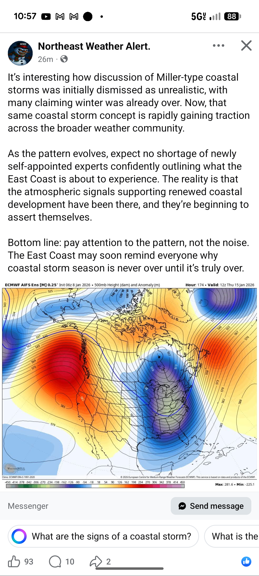
Yup, 16th is a Miller A that's wide right. -
but there's no reason to believe it's not either. It's a crap shoot!
-

January 2026 regional war/obs/disco thread
SouthCoastMA replied to Baroclinic Zone's topic in New England
And Ray's favorite, a Miller A, developing later on. Just fantasy, but funny stuff. Would surely crush the south/Mid Atlantic -
A key ingredient for any legitimate snowstorm in these parts.
-

January 2026 regional war/obs/disco thread
Typhoon Tip replied to Baroclinic Zone's topic in New England
As an influential posters it is probably equally annoying for us to swing between tones of optimism and then despair, inside the same hour LOL buuut... Re the GFS operational. I do like the position of the western ridge better in this run than the previous. Previous left ... new position right That S/E repositioning may seem subtle but it is crucially important/sensitive in how the wave spacing behaves wrt S/Ws ejected down stream. The subtly more compression along the Rockies S flow on the right is also an homage to attempting a ridge farther S/E. You don't ( as winter even enthusiasts ..) want to see the left variant of the +PNA. ... As much. I mean I'm sure in the last 3,000,000 years of eastern N/A there's been event with the left version... but excluding the rarefied scenarios. Anyway, bump that a little more and it would be better.
-

January 2026 regional war/obs/disco thread
tamarack replied to Baroclinic Zone's topic in New England
Haven't heard any traffic on the club trail thru our woodlot, though I might've missed some. Had 12" at the stake this morning, but the northerly 100 yards of trail on us require 15-18" of dense pack to avoid having the groomer clanging on the rocks. -

January 2026 regional war/obs/disco thread
ma blizzard replied to Baroclinic Zone's topic in New England
lets melt all the snow before the next Arctic blast .. sounds about right -
-
lol there's a 1043 high over ontario on the GFS (at the end)
-
Very helpful info - thanks for taking the time to add this.
-
-
Favorable pattern doesn’t guarantee KU’s
-
Spring showers bring…
-
Of course some ridiculous set up developing at the end of gfs run.
-
No point over analyzing anything beyond day 5. But it is a Nina and I suspect at some point the Outer Banks up to VA Beach will get smacked while we enjoy cold cirrus. Let's save our sanity and accept that now. 50F at noon. Just sitting here being patient for the time being.
-
There's literally a coastal storm signal on a bunch of the models for the 15th/16th. This comment makes no sense. .
-
There's no reason to believe there's any better period coming out beyond the range of models.
-
Still a good signal for next weekend on the 12Zs so far. Agree we see a reload by the end of the month.
-
i disagree, i think our biggest snow threat this year will be next week. That favorable pattern continues into february
-
January 2026 regional war/obs/disco thread
dryslot replied to Baroclinic Zone's topic in New England
GFS misses with a coastal on the 16th but has something on the 18th now.