All Activity
- Past hour
-
Euro looking alot like the gfs
-
OP looks real nice. What could go wrong?
-
Euro another small tick slower this run.
-
Gotcha. I'm just curious what the south did to hurt them, lol.
-
Exactly what I was thinking .
-

1/23/26-1/25/26 Winter Storm Thread
Holston_River_Rambler replied to AMZ8990's topic in Tennessee Valley
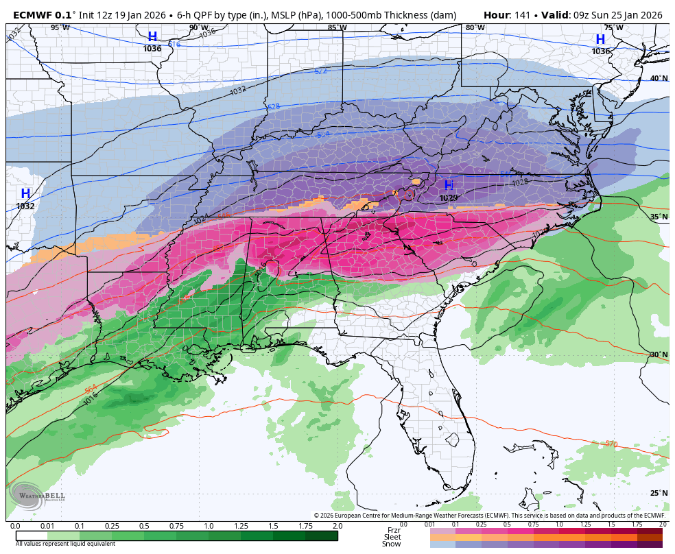
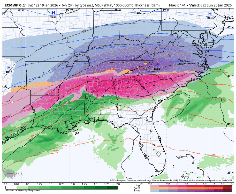
6z Euro surface pressure trend: If we just end up with that little lp blob over the Snokies turning into a leeside low...... -

1/23/26-1/25/26 Winter Storm Thread
Save the itchy algae! replied to AMZ8990's topic in Tennessee Valley
If it’s stopped it’s northward jog already then we’re in business. 1.5 more days until it’s largely locked in. . -
Man I’d love to be in Maryland for this as I’ve waited 10 years for this kind of storm, but it will be tough for me. No need to feel bad though, I’m way up north now and can look forward to single digit highs this weekend You all better enjoy this, especially @SnowenOutThere and other young guys who’ve never seen a double digit storm above age 10.
-

Central PA Winter 25/26 Discussion and Obs
NepaJames8602 replied to MAG5035's topic in Upstate New York/Pennsylvania
Zero degrees here in my part of the Poconos at 630 am. Wind died down some, and snow pack really allowed temps to plummet. This weekend is now looking more interesting. It's a good thing being on the northern edge 4 to 5 days out imo. -

Possible Record Breaking Cold + Snow 1/25 - 1/26
SnoSki14 replied to TriPol's topic in New York City Metro
Euro AI with a nice hit. Models a bit slower (Sun into Mon) vs Sat evening/night into Sun. Slower is better for us as it allows high to weaken and lessens suppression risk -
I had that thought too. At that point we're calling Gov. Moore to airlift @Jebmanin to shovel us out. Godspeed Jeb Ok that's my banter for the day. Going to lurk mode... Looking forward to today's runs.
-
At some point I think ratios are going to matter with this cold. You can clearly see it on the precip maps where we might get less precip but the higher ratios make up for it in snowfall. I think we are any a great spot and if we have a jump north I assume the cold is not as strong and its mostly a wash with accumulations? Euro AI shows only a 2 inch difference between Fredericksburg and Mon county NJ. A distance of 250 miles.
-
6z Euro now showing a little appetizer on Friday AM. I would consider this a baroclinic leaf out of front of the main storm. Something to watch.
-
If this thing becomes a HECS, then your middle schooler might get most of the week off regardless of Monday. Thats what happened in 1996, 2003, and 2010.
-
1/23/26-1/25/26 Winter Storm Thread
Holston_River_Rambler replied to AMZ8990's topic in Tennessee Valley
6z normal Euro still dropping a 1054 hp south and it is a tick further south than 0z -
If that northern stream trough on the Euro was to sharpen some, it could tug the coastal back, or hold it in place an additional 3-6 hours, then we're not in business but in trouble. Lol
-
After a very quick glance, looks like the AIFS took another step in the right direction.
-

E PA/NJ/DE Winter 2025-26 Obs/Discussion
Duca892 replied to LVblizzard's topic in Philadelphia Region
NWS has the NBM at 40% of 5in+ all the way up to Allentown and Philly at 55% -
Big test for it
-
If this thing holds, Montgomery County school children (like my middle schooler) will be annoyed. They have off Monday for an end of quarter teacher grading day. I think the teachers have to report in though, so they will be happy.
-
-
1/23/26-1/25/26 Winter Storm Thread
Holston_River_Rambler replied to AMZ8990's topic in Tennessee Valley
6z continues its tick south: -

January 2026 regional war/obs/disco thread
UnitedWx replied to Baroclinic Zone's topic in New England
Yup, let's keep that up... to a point. The PV sort of splitting is telling to my barely trained eyes. Hopefully that's legit -
You know I always thought the gfs was the best model. Haters gonna hate. Was that me saying the gfs is garbage yesterday? No that was fountainguy96.
-
1/23/26-1/25/26 Winter Storm Thread
Holston_River_Rambler replied to AMZ8990's topic in Tennessee Valley
6z AIFS ha a pretty good look: