All Activity
- Past hour
-

White Christmas Miracle? December 23-24th
40/70 Benchmark replied to Baroclinic Zone's topic in New England
Good look, esp. NOP -
-

Possible Light Snowfall (1" - 4") on Tuesday Dec 23
snowman19 replied to Northof78's topic in New York City Metro
The GEFS doesn’t agree: https://www.pivotalweather.com/model.php?m=gefsens&p=sn10_acc-mean-imp&rh=2025122012&fh=90&r=us_ne&dpdt=&mc=&pwplus=1 -

White Christmas Miracle? December 23-24th
CoastalWx replied to Baroclinic Zone's topic in New England
Ukie came south too -
Some of the guidance has a little period of snow on Monday. Could be some high ratio stuff.
-
Quick, somebody get the "Summer Wheeze" to put him out of his misery already.
-

White Christmas Miracle? December 23-24th
bristolri_wx replied to Baroclinic Zone's topic in New England
NBM looks decent considering time range.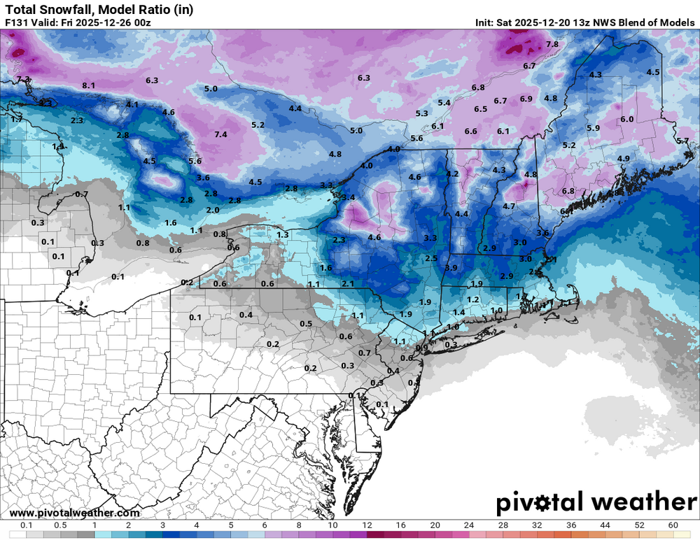
-
I flew out of DEN early this morning expecting a rough go. It was smoother than usual.
-

E PA/NJ/DE Winter 2025-26 Obs/Discussion
Voyager replied to LVblizzard's topic in Philadelphia Region
I speak only for myself, but you can kindly escort yourself out of the forum for posting that... -

Possible Light Snowfall (1" - 4") on Tuesday Dec 23
psv88 replied to Northof78's topic in New York City Metro
RRFS was by far the best model for the last storm -

Central PA Winter 25/26 Discussion and Obs
MAG5035 replied to MAG5035's topic in Upstate New York/Pennsylvania
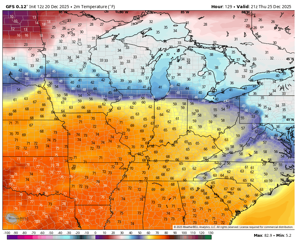
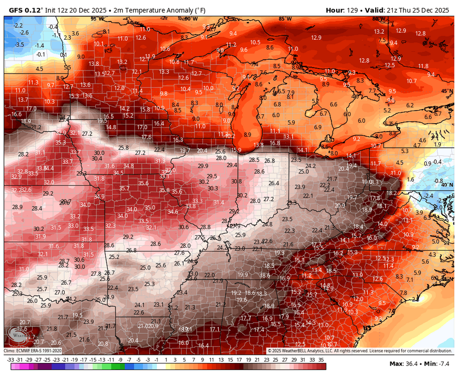
Maybe in western PA, cool air has a good chance of holding in the rest of the state east of the Alleghenies Christmas Day. GFS a bit cooler than the Euro (actually slightly below average in eastern PA), but even the Euro only has MDT getting into the low 40s or so. Even if it did bust 50 degrees the +5 to 10 departure that would make high-wise is pretty tame compared to where the real torch is centered. + Anomalies Christmas Day in the central plains are bananas, in the realm of 30-40 degrees above average. We may have a couple fairly warm days on or just after Christmas, but the -NAO blocking is likely going to keep us from being overrun with any kind of warmth like that. 12z GFS temps/anomalies
-
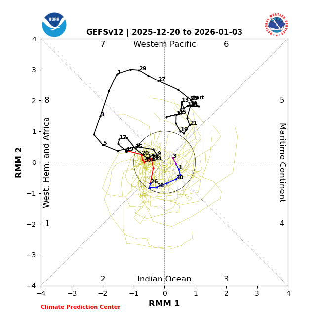
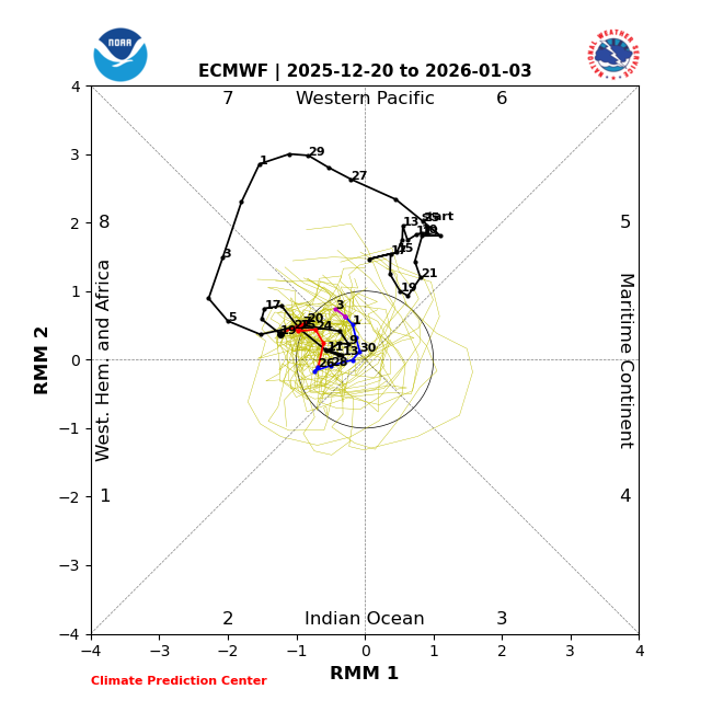
The GEFS and EPS have big disagreement 12/25-1/3! Fwiw, JMA, BOM, and CFS favor GEFS: Meanwhile, phase 8 , which helped bring strong cold Dec 3-7 and Dec 15 but won’t next week, returned on 12/17 and will likely be with us for awhile:

-

December 2025 Short/Medium Range Forecast Thread
Daniel Boone replied to John1122's topic in Tennessee Valley
Yeah, he's pretty concerned. -
(002).thumb.png.6e3d9d46bca5fe41aab7a74871dd8af8.png)
Central PA Winter 25/26 Discussion and Obs
ChescoWx replied to MAG5035's topic in Upstate New York/Pennsylvania
A return to chillier weather today with highs in the mid-40's. We stay below normal through Monday with maybe some wet snow arriving toward Tuesday morning. This should turn to rain pretty quickly from SW To NE across the area. Temperatures look to be near normal for Christmas Eve Day before we rise to about 4 degrees above normal for Christmas Day. Boxing Day looks to be the warmest day of the week before we cool down as we move toward the New Year's holiday.

-
E PA/NJ/DE Winter 2025-26 Obs/Discussion
ChescoWx replied to LVblizzard's topic in Philadelphia Region
A return to chillier weather today with highs in the mid-40's. We stay below normal through Monday with maybe some wet snow arriving toward Tuesday morning. This should turn to rain pretty quickly from SW To NE across the area. Temperatures look to be near normal for Christmas Eve Day before we rise to about 4 degrees above normal for Christmas Day. Boxing Day looks to be the warmest day of the week before we cool down as we move toward the New Year's holiday.
-

White Christmas Miracle? December 23-24th
WinterWolf replied to Baroclinic Zone's topic in New England
Yes sir…you’ve been on this. And let’s juice it up to a solid advisory event for SNE. If we could do that…I’d be close to average December snow. -
December 2025 Short/Medium Range Forecast Thread
Daniel Boone replied to John1122's topic in Tennessee Valley
Good post man ! -

Occasional Thoughts on Climate Change
TheClimateChanger replied to donsutherland1's topic in Climate Change
-

White Christmas Miracle? December 23-24th
dendrite replied to Baroclinic Zone's topic in New England
Subtle difference with the handling of the vortmax by the gfs xmas eve morning. It drives the dPVA a lot more south while the other models curl it up into the GOM. This is more about the inverted trough possibility and not the initial overrunning in SNE.
-
Occasional Thoughts on Climate Change
TheClimateChanger replied to donsutherland1's topic in Climate Change
2250? That seems rather optimistic. -
Occasional Thoughts on Climate Change
TheClimateChanger replied to donsutherland1's topic in Climate Change
-
Yw !
-

E PA/NJ/DE Winter 2025-26 Obs/Discussion
Birds~69 replied to LVblizzard's topic in Philadelphia Region
Lock it in but I know we cannot be that lucky... 32F -

White Christmas Miracle? December 23-24th
WxWatcher007 replied to Baroclinic Zone's topic in New England
I’ve liked this signal for like a week now. Trends overall continue to be good for many. Let’s bring it home. -
White Christmas Miracle? December 23-24th
dendrite replied to Baroclinic Zone's topic in New England
Yeah both CMC models are pretty far north with the surface relection. I’d probably toss the gfs for now on a possible part deux unless the euro comes in south of ART.