All Activity
- Past hour
-
And just like that @Ralph Wiggum
-

Winter 2025-26 Short Range Discussion
KeenerWx replied to SchaumburgStormer's topic in Lakes/Ohio Valley
Happy that the CAMs nudged a little east over the day. They were hinting at a local miss by ~10 miles for the heavier stuff. I know that’s the way it plays with LE. But the psychology of this hobby makes it more preferable that any miss is wide. Anyway, it’s always fun to see some of the output as we get closer. Even though some are notoriously over-juiced. Big time heartbreaker for Michigan City area in this particular outcome.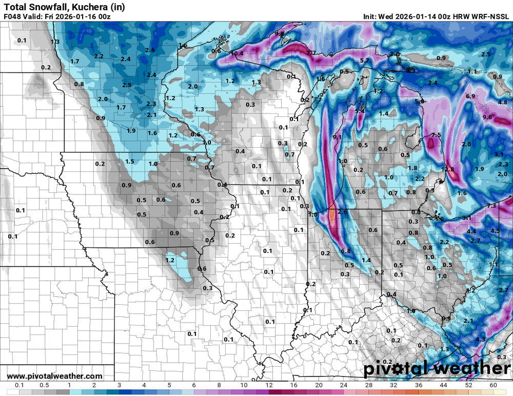
-
The shortwave gets stuck in the SW
-
At least Ji doesn’t live in southern PA or else we’d have to hear about him “losing” 60 inches in one run
-
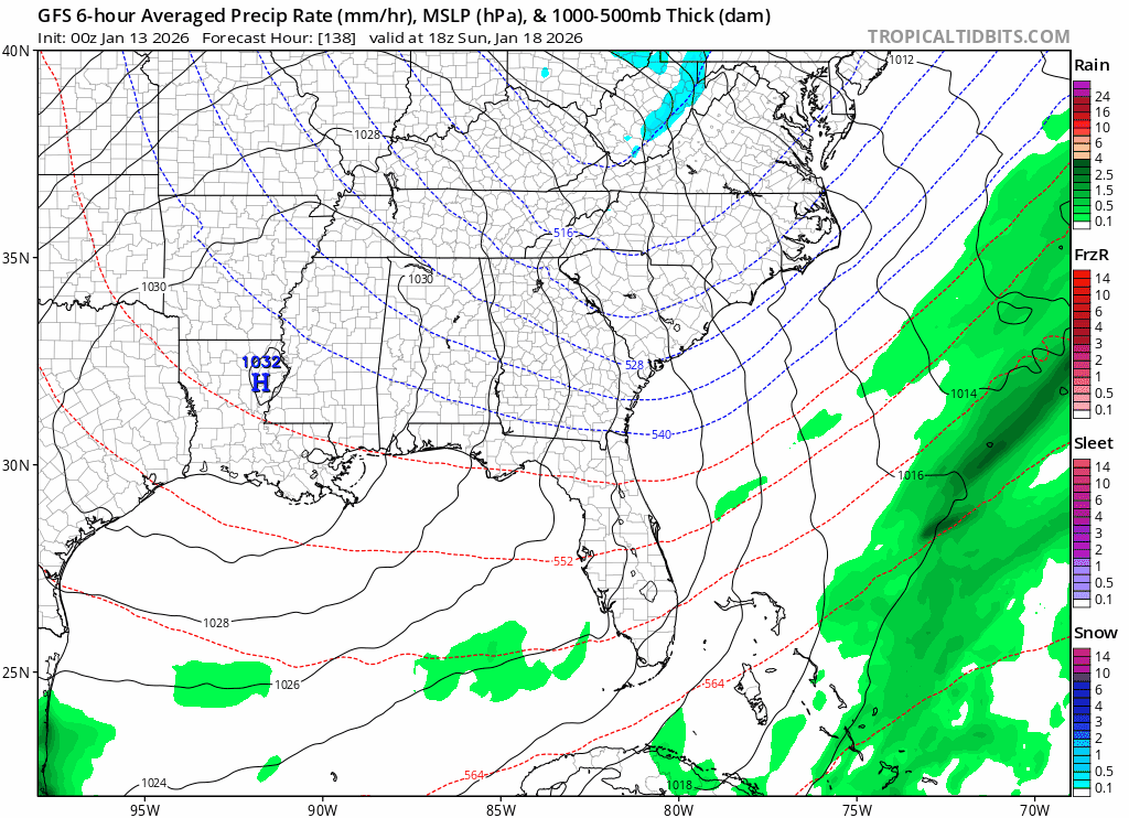
The GEFS improved again for Sunday (trof and individual members) even if QPF doesn't fully reflect the improvement.
-
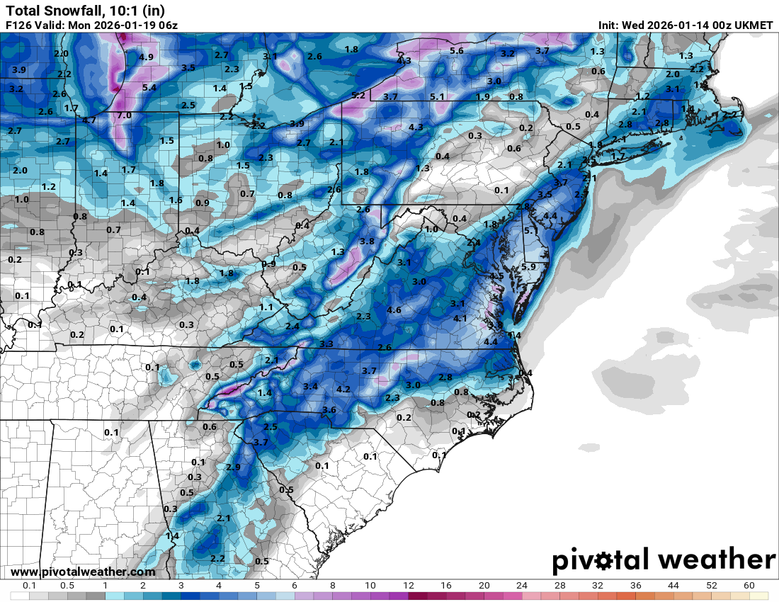
what's the ceiling for this type of event?
-
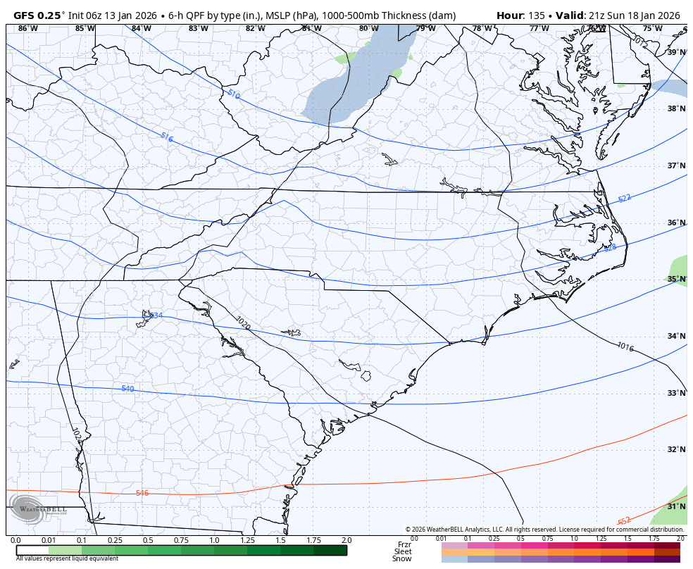
The UK is similar to the GFS, but better. Accumulating snow to the coastal plain just NW of NYC. Nice h5 and surface almost as good as GFS-AI. Great 0z.
-

January 2026 regional war/obs/disco thread
The 4 Seasons replied to Baroclinic Zone's topic in New England
I never could have guessed this would happen, i thought it was 100% lock! The vanishing act of clown range op runs, who could have guessed
-
It's not a cutter, it's not suppressed, it literally went poof. 100% gone.
-

January 2026 Medium/Long Range Discussion
NorthArlington101 replied to snowfan's topic in Mid Atlantic
Yea, but UKIE likes the @CAPEstorm.
-
From what I can tell, they were predominantly East based Larry ,Just running off memory. Maybe you can find more clarity on that. Also, blocking looks to of been in place. I remember the long cold stretch in 2011 well. Incidentally, as I'm sure you know, that was a fairly strong Nina. Strong Blocking that Winter.
-
lfg!
-
GFS went poof for the @NorthArlington101 storm.
-
Ok. If we can find whether it was east west or basin wide those cold Year's.
-
Hope you’re right. It has been an historically abnormally warm and nearly snowless stretch for a sizable portion of the West this season so far. While that to some extent is to be expected at times with climate change, unfortunately, the giant leap we’ve very recently seen towards hot/dry is so extreme that it seemingly must revert towards the mean soon. Also, appreciate the added ~Western perspective in a forum dominated by the eastern approximately 25% of the country. No criticism intended, but what happens in New England, the Great Lakes, and northern middle Atlantic represents a small portion of the U.S. geographically.
-
I don’t think I can because I don’t have a list of La Niña by location. If you can provide that, I can break it down.
-
I'm not really sure what fast flow means here in context. In the past I think it referred to an anomalously strong jet stream across the Pacific that penetrated the North American continent with mild air. "Fast flow" seems to have become a scapegoat when anything fails regardless of cause. In this case the flow is straight out of central Canada and the flow looks seasonably fast, i.e., not too fast. The speed of a SLP is partly dependent on steering currents but also on the structure and degree of maturity of a trof. For example, a SLP may slow and stall near a cutoff upper level low even if the associated jet has winds speeds over 80 knots.
-

Central PA Winter 25/26 Discussion and Obs
pasnownut replied to MAG5035's topic in Upstate New York/Pennsylvania
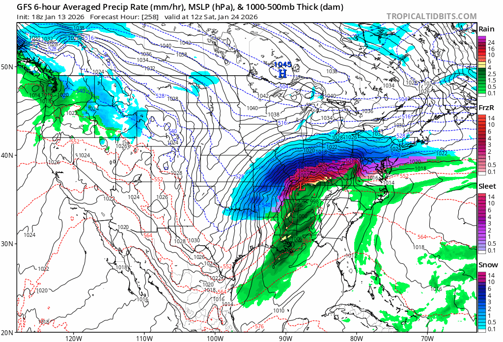
and as I suggested a few days back, it might be into the mid range until things get sorted out. With that in mind, 0z's are coming around to the idea of a lot coming at us, and look a tad better for this weekend as well. ICON/GFS/CMC are stepping in the right direction. 1/24 nuke job, we'll find out in a few. -
I'd gladly take what the cmc is showing for Saturday. A nice region wide 1 to 3
-
The GEM drops the energy in a couple hundred miles west of the GFS it looks like. Further east, no go, further west, better for us.
-
4 seasons - I love your website! Talk about COMPREHENSIVE! https://www.jdjweatherconsulting.com/storm-archive It's goin in my new SMF message board. Had to go get a new one, because Invision Power Boards is forcing everyone to pay 100 dollar a month or even more!
-
Thats the problem of late
-

Mid-Long Range Discussion 2026
gamecockinupstateSC replied to BooneWX's topic in Southeastern States
-
GFS trending in the right direction.
-
Could the die roll have been on to something? Is this thing coming back?