All Activity
- Past hour
-
Gfs has a nice cool down in the long range.
-
i do not see that happening with a trough in the west
-
This is basically a normal to slightly below normal snowfall winter
-
Might as well put Huntley in for the second half. A least he can run a bit. But ofc Harbaugh wont do it. If the offense cant sustain some drives this defense is gonna give up 50 today.
-

Spooky Season (October Disco Thread)
moneypitmike replied to Prismshine Productions's topic in New England
And I though the 76 here was crazy. -
But we haven’t done it since the winters shifted warmer in 15-16 followed by the warmer storm track shift in 18-19. So 11 years ago and 30 years ago featured a much different winter global circulation pattern with the colder temperatures which made those outcomes possible. Pre-1994 was a colder and more stable climate era which favored snowfall outcomes focused more toward the midrange with fewer big highs and big lows for snowfall. Especially near NYC Metro, snowfall has become an all or nothing proposition since 1994 with many years well above and well below which was common prior to that era. We have seen nearly no snowfall seasons near the mid range which was common prior to 1994. So while we experienced all the record snowfall from 1994 to 2015, we didn’t pay as much attention to the very low years in the mix and lack of midrange years. We were still able to hold onto great snowfall outcomes from 2016 to 2018 around NYC with the storm tracks remaining cold. But just not quite the level of the pre 15-16 era due to the record warmth which became more common starting in December 2015 with went +13.0. Since 18-19 the continuing much warmer winters and added much warmer storm tracks have featured a dominant cutter, hugger, and suppressed Southern Stream storm tracks. This has lead to the record low I-95 snowfall since then. Most seasons have been much below with very few well above and midrange winters around NYC Metro.
-
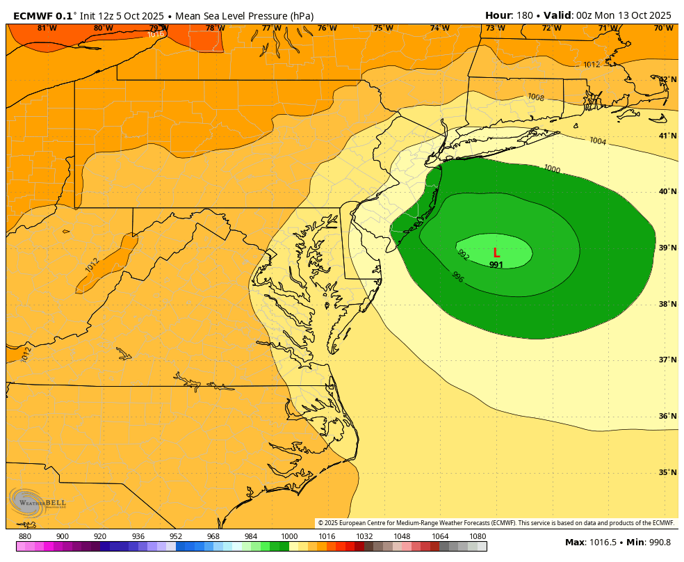
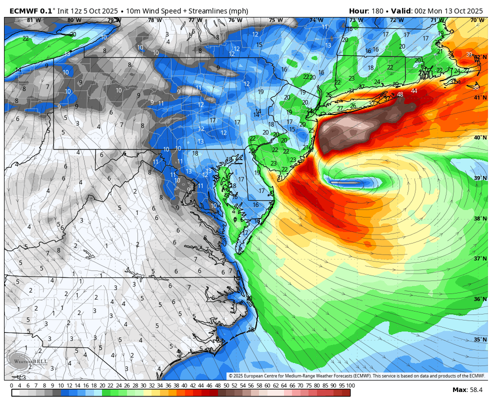
I was wondering what’s the deal with that hybridish nor’easter offshore the E coast this weekend into next week? It’s on all 12Z major ops in one form or another. As you implied, the 12Z Euro has this, which had moved NNE from off the SE US and then turns sharply left into NJ in Sandy fashion:


-
Still looking like the first major cold front of fall will pass just after mid-month with the first frost/freeze possible around that timeframe.
-
All the injuries aren't an excuse. The D was awful before. The Niners managed to beat the Rams with a rash of injuries the other night, because they have good coaching.
-
Not a problem for the Ravens today lol
-
Hey Charley, I need to put a detailed post together about the net benefits of CC on crops and will do that ASAP!
-
What’s with that hybridish nor’easter offshore the E coast this weekend into next week? It’s on all 12Z major ops in one form or another.
-
Spooky Season (October Disco Thread)
moneypitmike replied to Prismshine Productions's topic in New England
Call it a wrap.
-

-
Regular euro too but on Sunday
-

Spooky Season (October Disco Thread)
TauntonBlizzard2013 replied to Prismshine Productions's topic in New England
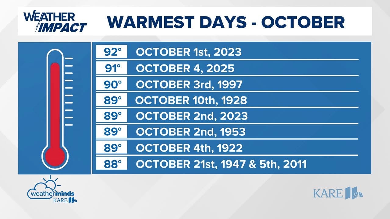
84 degrees mid day October 5th. Not normal -

Spooky Season (October Disco Thread)
metagraphica replied to Prismshine Productions's topic in New England
Or Christmas. -
87 for high thus far Push push
-
We're on day 3 out of 4 of above 28C/82.5F highs with Sat reaching 30C! I was irked in Sept that we didn't have any highs above 25C; I needed more and Oct delivers. Last week 4 out of 7 days had few if any clouds too, crazy. Low was 17C, it was nice waking up without feeling cold in t-shirt and shorts. That low is higher than the daytime avg high.
-

Spooky Season (October Disco Thread)
Damage In Tolland replied to Prismshine Productions's topic in New England
All AWT Steiner -
12z EURO AI has major rainstorm starting day 6. I would post a loop but file size max limit is too small.
- Today
-

Spooky Season (October Disco Thread)
Torch Tiger replied to Prismshine Productions's topic in New England
Euro is a trainwreck locally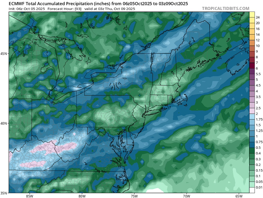
-
Spooky Season (October Disco Thread)
Torch Tiger replied to Prismshine Productions's topic in New England
gfs has like .3 -.5 here to N CT. cut back since it backed off that mid-level wave -
.thumb.png.4150b06c63a21f61052e47a612bf1818.png)
Spooky Season (October Disco Thread)
HIPPYVALLEY replied to Prismshine Productions's topic in New England
Ensembles only show around quarter of an inch. -

Central PA Fall Discussions and Obs
Voyager replied to ChescoWx's topic in Upstate New York/Pennsylvania
Hour past nooners and 83 here...so far. Part of me wishes we'd stay this warm through Halloween. Outside of a few early turners, nearly all the trees are still summer green. The anomaly lover in me wants to see how long it would hold, or would the lack of sunlight/photosynthesis turn them regardless of the summer-like temps.