All Activity
- Past hour
-

Major Hurricane Melissa - 901mb - 175mph
40/70 Benchmark replied to GaWx's topic in Tropical Headquarters
Well, the two aren't mutually exlusive. -
that guy is an idiot
-

Spooky Season (October Disco Thread)
CT Valley Snowman replied to Prismshine Productions's topic in New England
Another heavy frost with a low of 30. -
This is actually heartbreaking. The track eluding guidance initially likely put in some false hope of a near miss “miracle”
-

Major Hurricane Melissa - 901mb - 175mph
kat5hurricane replied to GaWx's topic in Tropical Headquarters
I actually think the slight east jog is a tiny blessing as Negril and Montego Bay might get spared the absolute worst in terms of wind, the rain is going to be a big story either way. -
Should get a reading from recon shortly and then at least one more. Second mission is on the way but could be tight in getting there before landfall.
-
(002).thumb.png.6e3d9d46bca5fe41aab7a74871dd8af8.png)
Central PA Fall Discussions and Obs
ChescoWx replied to ChescoWx's topic in Upstate New York/Pennsylvania
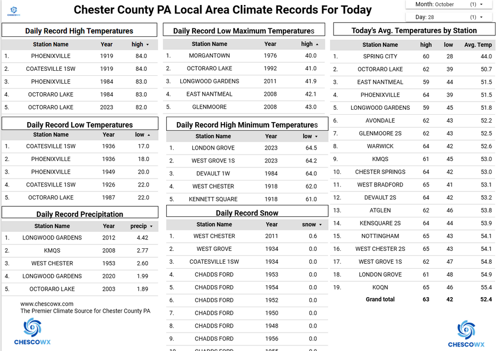
Another morning of freezing temperatures in the valleys and more than a dozen degrees warmer up in the hills of the area. Warwick Township had a low of 25.0 degrees this morning....yet here in East Nantmeal we were exactly 12 degrees warmer at no lower than 37 degrees. Our below normal temperature trend continues through the week with the one exception of Thursday. That day should be near normal temperatures....but with the trade off of rain. This still looks to be the most significant rain for the area since midsummer. Models paint between 1.5" to 2.5" across the area. Behind the storm we turn chillier again but dry for Halloween and the first weekend of November.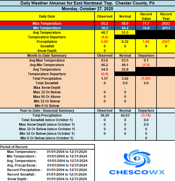
-
E PA/NJ/DE Autumn 2025 Obs/Discussion
ChescoWx replied to PhiEaglesfan712's topic in Philadelphia Region
Another morning of freezing temperatures in the valleys and more than a dozen degrees warmer up in the hills of the area. Warwick Township had a low of 25.0 degrees this morning....yet here in East Nantmeal we were exactly 12 degrees warmer at no lower than 37 degrees. Our below normal temperature trend continues through the week with the one exception of Thursday. That day should be near normal temperatures....but with the trade off of rain. This still looks to be the most significant rain for the area since midsummer. Models paint between 1.5" to 2.5" across the area. Behind the storm we turn chillier again but dry for Halloween and the first weekend of November.
-
N to NW winds there right off the water and near western eyewall. Hopefully it’s east of them.
-
I’m a little worried about them. It could be nasty there.
-
https://bsky.app/profile/creacleanair.bsky.social/post/3m46yyz2dor2a
-
The WPAC to the east of Japan is different from the EPAC since the Kuroshio Current like the Gulf Stream waters are certainly warm enough to cause a feedback process. But the wam blob off the West Coast during the 2010s was the result of the forced pattern emanating in the subtropical or tropical WPAC . So once the fall pattern in 2019 shifted the warm blob easily disappeared. This is why 19-20 wasn’t a repeat of 13-14 like some were speculating about that fall. So more remotely forced. The WPAC warm pool is much more stable and longer lasting since both the forcing and SST feedback are at play for pattern maintenance.
-
Anyone have any good live feeds from near the landfall locale?
-
Looks like they'll (NHC) be dead nuts actually. Everyone was thinking Montego was going to be on the eastern eyewall lol.
-
Major Hurricane Melissa - 901mb - 175mph
40/70 Benchmark replied to GaWx's topic in Tropical Headquarters
One of the "best" areas that it could have hit in terms of population....west jog did us a small solid. -
We may have landfall just after noon, perhaps by 1PM EDT. Trying to approximate this while considering that the forward motion is also slowly increasing as well.
-

Major Hurricane Melissa - 901mb - 175mph
NorthArlington101 replied to GaWx's topic in Tropical Headquarters
Not looking like a miss, despite that hour detour on this forum yesterday. Shocking how all guidance and the NHC were right. -
Even Reed Timmer is sitting this one out. RIP Jamaica.
-
46 here
-

Spooky Season (October Disco Thread)
dendrite replied to Prismshine Productions's topic in New England
RGEM and NAM get the secondary going around NYC and track it over SNE up to coastal ME. Hopefully that keeps the rain going a little longer and heavier up here. -
Major Hurricane Melissa - 901mb - 175mph
40/70 Benchmark replied to GaWx's topic in Tropical Headquarters
Yea, St Elizabeth's Parish will get wiped.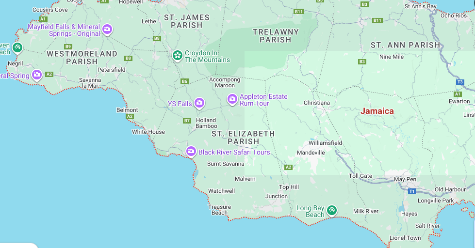
-
Knots are less annoying to me when considering degrees, minutes, and seconds. It’s kind of cool actually.
-
It almost looks like whatever restructuring occurred in the early morning hours allowed for the eye to expand a bit.
-
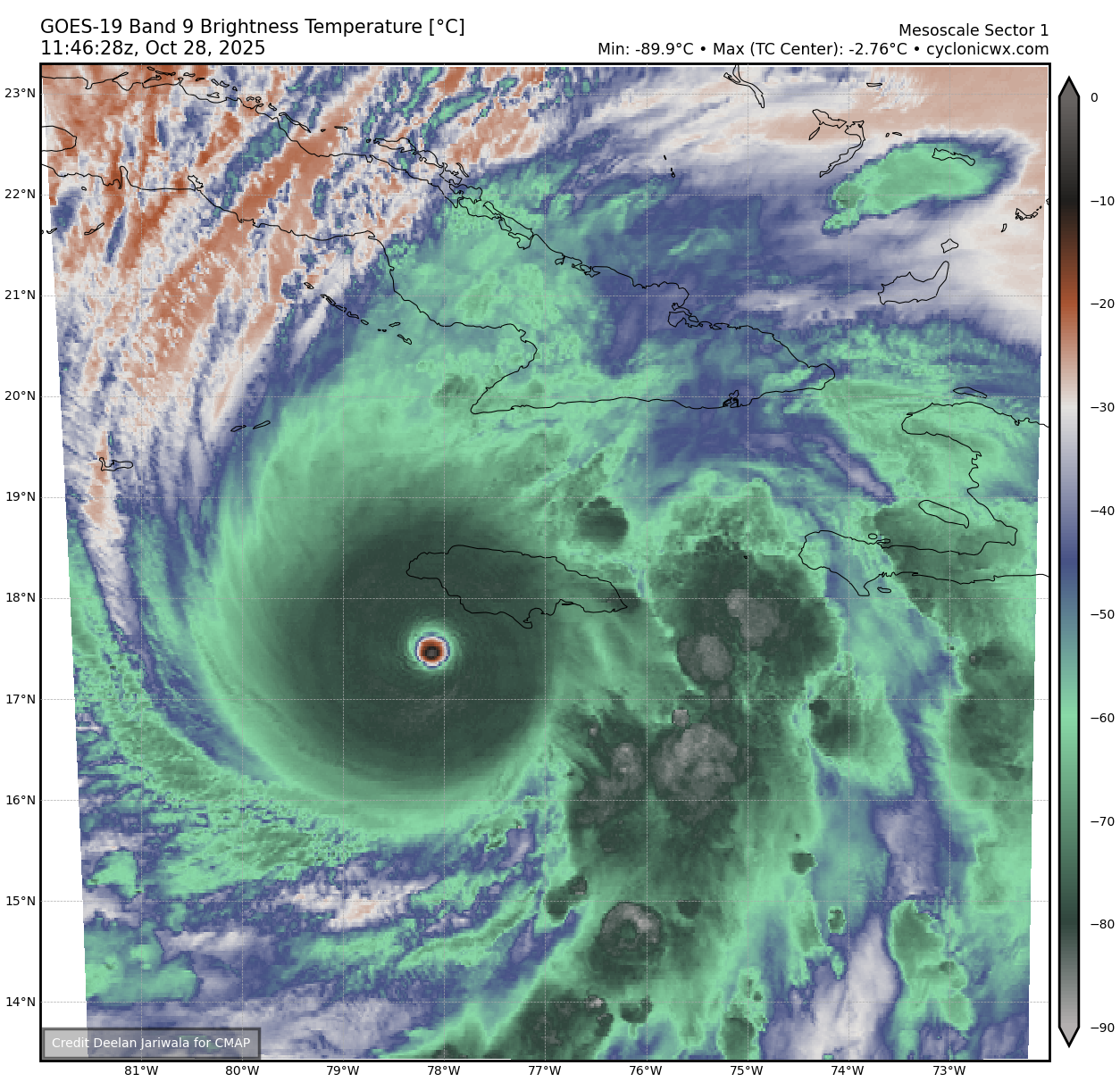
WV eye temp rose to -2.76C!

-
Getting a little forward motion giving it a little more warm water to strengthen? Hopefully hits in the middle where it's mostly goats and chickens.