All Activity
- Past hour
-
Hopefully the warm up in the long range verifies. Im trying to sell my house and need the marsh to green up.
-
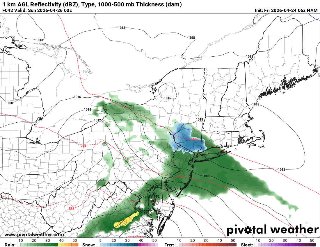
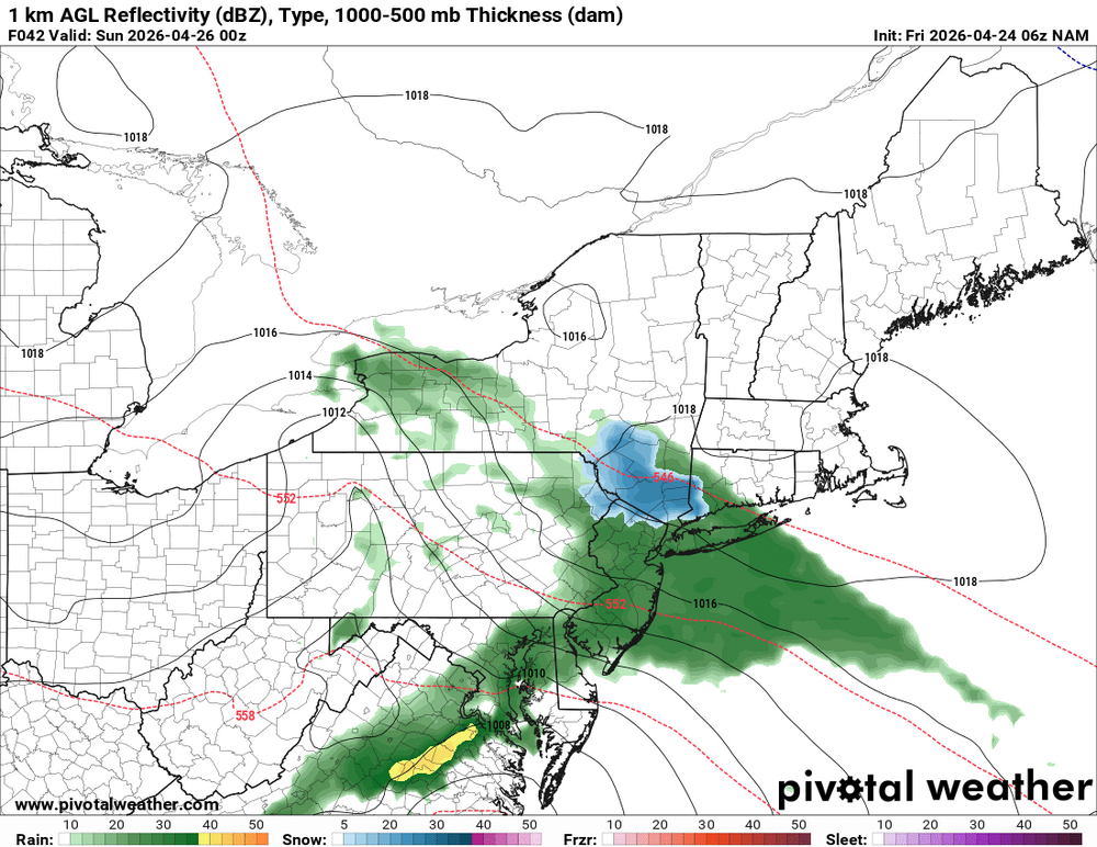
WPC qpf for the weekend
-

2026-2027 El Nino
bluewave replied to Stormchaserchuck1's topic in Weather Forecasting and Discussion
The Western Pacific warm pool was so overpowering that we got a La Niña pattern instead of the classic weak El Niño. https://www.climate.gov/news-features/blogs/enso/csi-enso-case-missing-central-pacific-rainfall -
Hopefully we can end the freezes after tomorrow morning.
-
-
Just got my shovel and bucket of rock salt out of the basement, all set here. I can’t back that up.
-
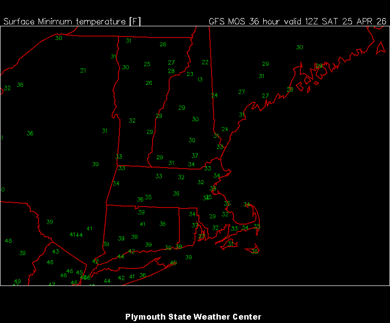
Sneaky cold this morning. 32° with some wind
-

Central PA Spring 2026 Discussion/Obs Thread
mahantango#1 replied to Voyager's topic in Upstate New York/Pennsylvania
https://www.pennlive.com/outdoors/2026/04/fruit-growers-estimate-some-90-100-losses-due-to-freeze-in-eastern-pa-northwest-nj.html?utm_campaign=pennlive_sf&utm_medium=social&utm_source=facebook&fbclid=IwY2xjawRYLW5leHRuA2FlbQIxMQBzcnRjBmFwcF9pZBAyMjIwMzkxNzg4MjAwODkyAAEeDOe8Gcq3UC0xqmt_NN1mYLUbZcmA5O0g-7ofUeIZdMTxYFoBuPEmkW72YWo_aem_RCFZu1cIk3mqSMKkP8HFBw -
Central PA Spring 2026 Discussion/Obs Thread
mahantango#1 replied to Voyager's topic in Upstate New York/Pennsylvania
US National Weather Service State College P· · Welcomed rainfall forecast over moderate to severe drought areas in south central and southeast PA through the last weekend of April Noticeable cool down on Saturday with highs 10-15°F below average across the eastern half of PA 4/24/26|516am -

2026-2027 El Nino
snowman19 replied to Stormchaserchuck1's topic in Weather Forecasting and Discussion
-
Steiner
-
What a raw crappy weekend coming up. I thought Sunday could be spared but even that's questionable
- 819 replies
-
- 1
-

-
- april showers bring may..
- rain
- (and 2 more)
-
Brutal weekend down here in Jersey. New England gets lucky.
- Today
-
-
Agree on both. WRT magnitude, I believe that south coast percentage is skewed low.
-

Central PA Spring 2026 Discussion/Obs Thread
Voyager replied to Voyager's topic in Upstate New York/Pennsylvania
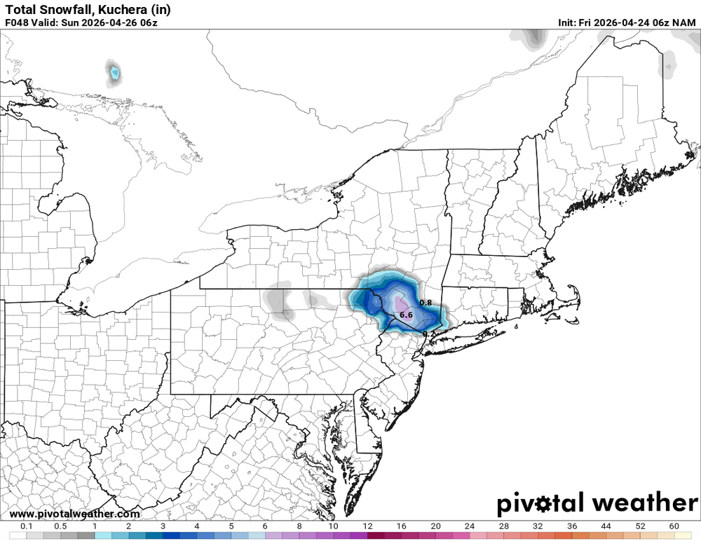
Not really upset about the rain, although it will mess up a rare opportunity to see one of my high school senior grandson's baseball games, which will likely be postponed. We need it. It's the temperatures, which once again drop down into the mid 40's making for a wreched day... Saturday: Rain. High near 46. East wind 6 to 8 mph, with gusts as high as 22 mph. Chance of precipitation is 90%. New precipitation amounts between a half and three quarters of an inch possible. -

Canada Storm-Specific SVR/TOR Warnings
vortex95 posted a topic in Weather Forecasting and Discussion
On 6/26, MSC will begin storm-specific SVR and TOR warnings. See here: https://dd.meteo.gc.ca/doc/genots/2026/04/21/NOCN04_CWAO_211100___07621 This is good b/c before you'd see huge area outlined in warnings on apps like RadarScope. Now they will be smaller and more focused. -
I'll post this on the general forum, but since this is relevant for NNE, I'll post it here. On 6/26, MSC will begin storm-specific SVR and TOR warnings. See here: https://dd.meteo.gc.ca/doc/genots/2026/04/21/NOCN04_CWAO_211100___07621 This is good b/c before you'd see huge area outlined in warnings on apps like RadarScope. Now they will be smaller and more focused.
-
2026-2027 El Nino
snowman19 replied to Stormchaserchuck1's topic in Weather Forecasting and Discussion
Nino Region 1+2 SSTs are exploding as the 1st kelvin waves are breaking at the South American coast and have begun surfacing And the area of +6C in the subsurface is expanding rapidly -
Scott this evening..."WHY CAN'T WE GET THAT HERE??!!"
-
I really love the Makai Lemon pick. I believe we got the best receiver in the NFL Draft. Lemon should have went ahead of Jordyn Tyson.
-
probably since the 2013 moore tornado..
-
Not NYC related, but holy crap... Oklahoma got destroyed. Haven't seen a tornado that scary in a while.
-
Let’s just say the nape has been fully bronzed these last several days, along with nearly everything else. But don’t worry gentlemen, I’ll be sure to bring as much of this bliss back north upon my return! It’s coming, hang in there baby.

-
Skunked again. Bummer