All Activity
- Past hour
-
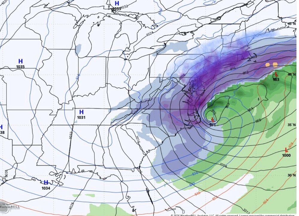
 It’s so tantalizing to have a 978 that close to us when we’re in a massive outbreak…
 -

Possible coastal storm centered on Feb 1 2026.
Ginx snewx replied to Typhoon Tip's topic in New England
Kev its Aerosmith in here. Same old song and dance my friend -

Possible coastal storm centered on Feb 1 2026.
dryslot replied to Typhoon Tip's topic in New England
I was comparing the 18z Nam with the 12z Euro at 500MB -

The “I bring the mojo” Jan 30-Feb 1 potential winter storm
ADB83 replied to lilj4425's topic in Southeastern States
Icon all but throws in the towel. Starting to leave the UK on an island. . -

2025-2026 Fall/Winter Mountain Thread
BlueRidgeFolklore replied to Buckethead's topic in Southeastern States
I wouldn't be surprised to see it tick upwards, either. -

Possible coastal storm centered on Feb 1 2026.
Baroclinic Zone replied to Typhoon Tip's topic in New England
That was a tasty look. We look but don’t touch. -

2025-2026 Fall/Winter Mountain Thread
strongwxnc replied to Buckethead's topic in Southeastern States
Straight GAs here . The GSP AFD is a great read today. Love ratio SLR talk -

Possible coastal storm centered on Feb 1 2026.
Kitz Craver replied to Typhoon Tip's topic in New England
Icon still a whiff but at least it didn’t shoot straight to Bermuda this run -

The “I bring the mojo” Jan 30-Feb 1 potential winter storm
btownheel replied to lilj4425's topic in Southeastern States
There may be nothing prettier in the weather world for us in NC than watching the overrunning ULL front end thump moisture hit the brakes as it crashes into an exploding coastal and start reversing course. . -
my initial thinking would be this
-
I would GLADY lock in 4-6in and call it a WIN.
-

The “I bring the mojo” Jan 30-Feb 1 potential winter storm
olafminesaw replied to lilj4425's topic in Southeastern States
RGEM looks really nice overall, but particularly for the foothills/NE GA crowd -
Possible coastal storm centered on Feb 1 2026.
Ginx snewx replied to Typhoon Tip's topic in New England
LFG -

1-30/2-1-26 Arctic Blast, ULL Snow Event
Daniel Boone replied to John1122's topic in Tennessee Valley
Yeah. It's looking more and more like that's a possibility. Hopefully the ULL will pull enough moisture into it before everything explodes east of us. Maybe we squeeze out a few inches rhat way. That 1980 Analogy is looking pretty spot on if that turns out to be the Case. I wish I knew the exact Date of that Storm . Need to look it up and see what the Setup was. As stated earlier, 3 inches here with a steady increase as you went Eastward. Eastern NC and SEVA was pulverized. Massive Drifts in Norfolk. This Winter is turning into a banner one for them considering the 3 Snowfalls in December they got. -
i don't know what to think tbh
-
what does the bolded mean? Found in the latest GSP AFD Furthermore, forecast soundings indicate incredibly cold profiles with a deep dendritic growth zone and plenty of forcing in part from strong DPVA with the upper low.
-

1-30/2-1-26 Arctic Blast, ULL Snow Event
Save the itchy algae! replied to John1122's topic in Tennessee Valley
All true, but these events are exactly why NE Tennessee averages the most snow in the state, without respect to elevation. Jelly for your locale. I chose west Knox blindly based on schools, if I had to do it again I’d be up your way somewhere or far north Knox or southern Anderson counties probably.- 116 replies
-
- 1
-

-
- extreme cold
- snow
- (and 1 more)
-
It keeps saying on Gemini that it favors the Blue Ridge more than the Triangle for heaviest snow.
-
Sorry, you’re not getting snow back to Eastern PA with a surface low 200 miles South of the benchmark.
-

Possible coastal storm centered on Feb 1 2026.
ineedsnow replied to Typhoon Tip's topic in New England
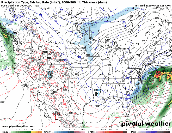
not enough on the ICON but closer -
-
Even the ICON inched in our favor w/ this run.
-

Possible coastal storm centered on Feb 1 2026.
dendrite replied to Typhoon Tip's topic in New England
ICON didn’t dig very south again. Not believing it until other models do the same. -
 Good trends so far. Need the King to come on board.
 -

The Jan 31 Potential: Stormtracker Failure or 'Tracker Trouncing
Solution Man replied to stormtracker's topic in Mid Atlantic