All Activity
- Past hour
-

Septorcher 2026 Discussion - Endless Summer
kdxken replied to Damage In Tolland's topic in New England
Anyway we get out of this next week without it being miserable? I need some hope. -
Is the steadier/heavier rain trending later in the day? Ive seen some forecast hinting at that but others not so much. Im trying to figure how doable some outdoor events will be Sun mid morning to early afternoon
-
Septorcher 2026 Discussion - Endless Summer
kdxken replied to Damage In Tolland's topic in New England
One can hope. -

Occasional Thoughts on Climate Change
TheClimateChanger replied to donsutherland1's topic in Climate Change
Here are some conceptual examples of what this would look like with winter temperatures: -

2026-2027 Record-breaking El Nino
mitchnick replied to Stormchaserchuck1's topic in Weather Forecasting and Discussion
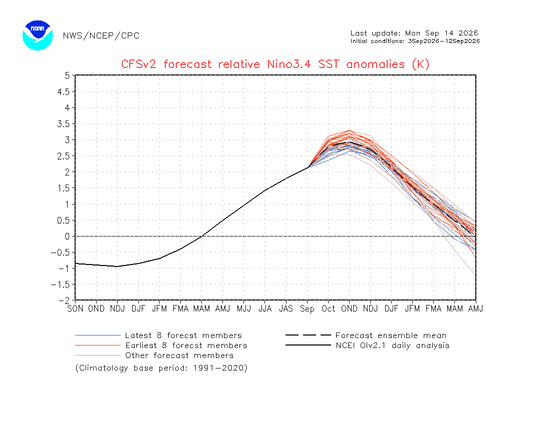
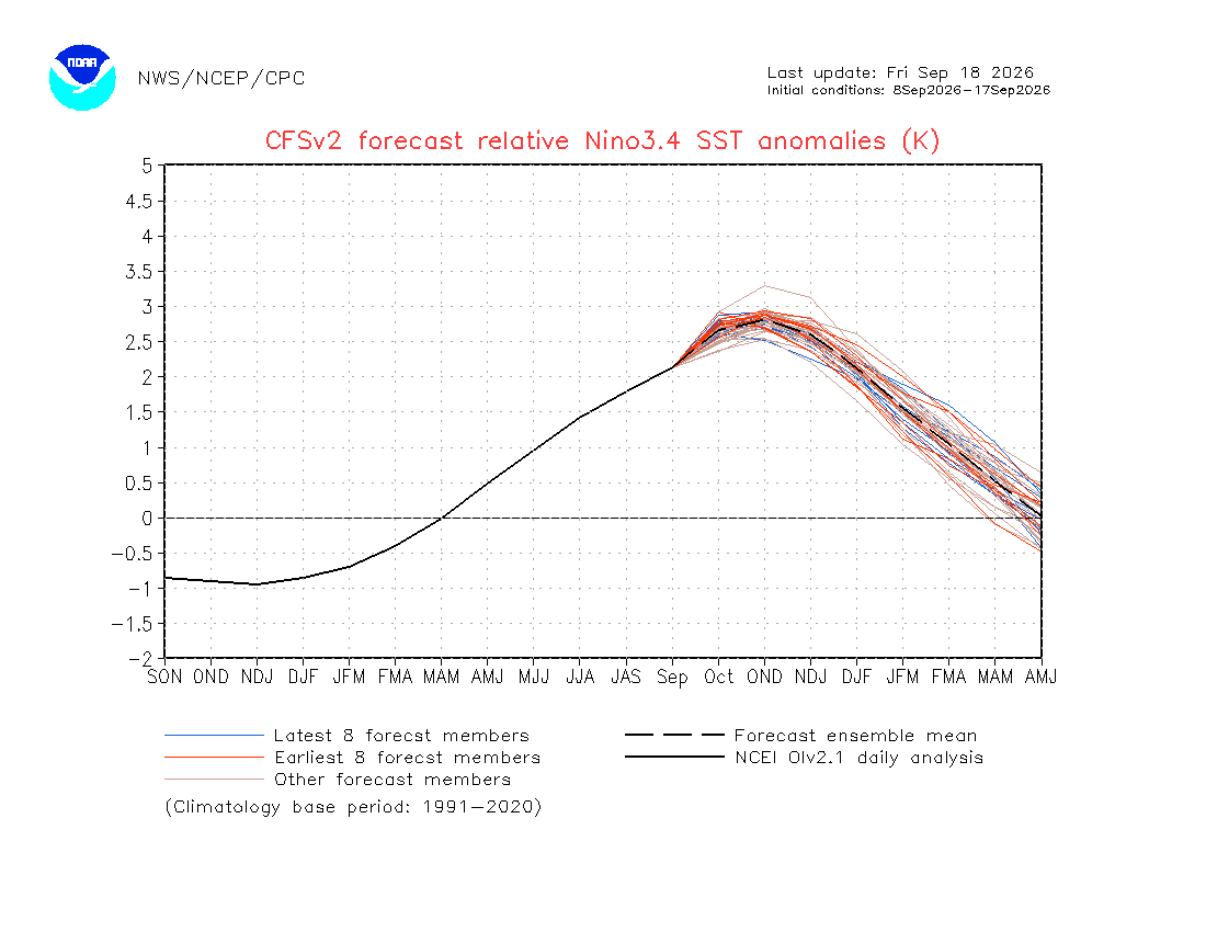
Cfs2 has a seperate link for the coming month. https://www.cpc.ncep.noaa.gov/products/CFSv2/monthly/ -

Central PA Summer 2026 Discussion/Obs Thread
Mount Joy Snowman replied to Voyager's topic in Upstate New York/Pennsylvania
Congrats that’s a big moment and a special time for you and her. I graduated in 2004 and have been a season ticket holder ever since. Have a great time! -

2026-2027 Record-breaking El Nino
GaWx replied to Stormchaserchuck1's topic in Weather Forecasting and Discussion
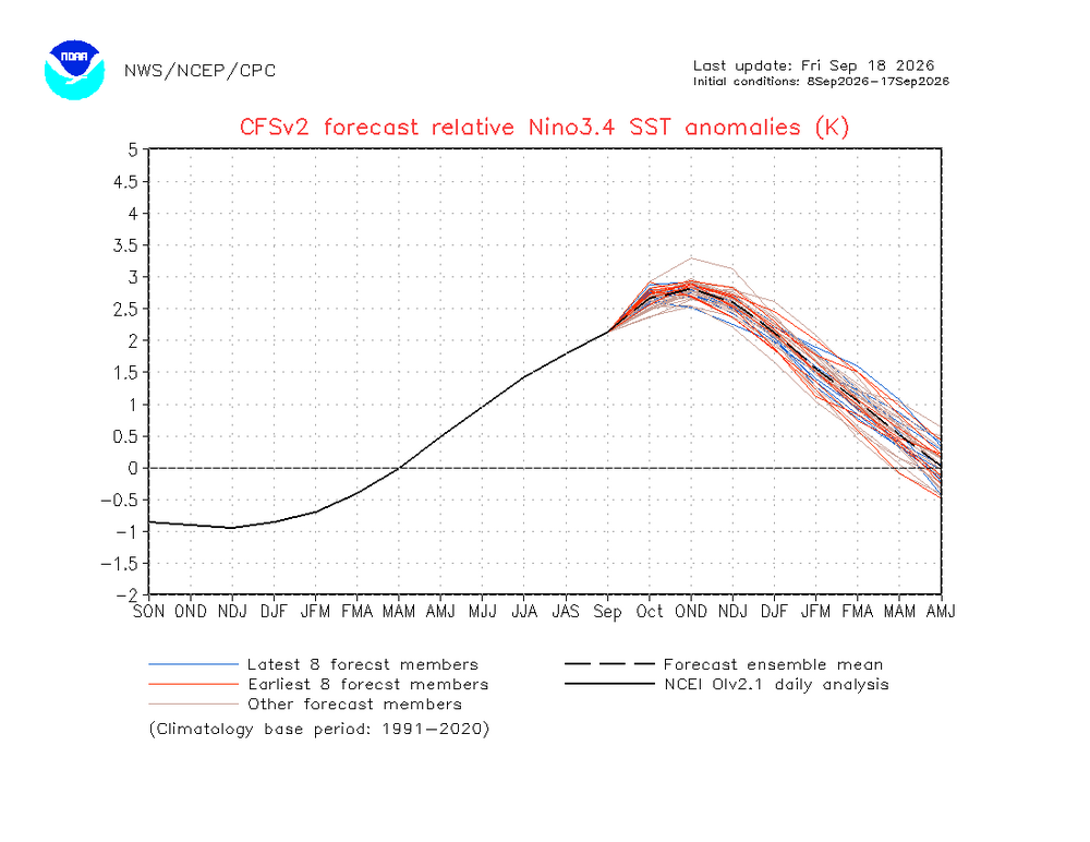
Follow-up: I emailed the 2 contacts who are listed at this CFSv2 site. Just minutes later, the site was updated! Here’s the brand new latest 10 day mean RONI forecast: as expected, the progged peak dropped even further to +2.8. Compare that to the +3.5 runs of late July. It appears it could even drop to +2.75 later this month based on the red vs blue lines: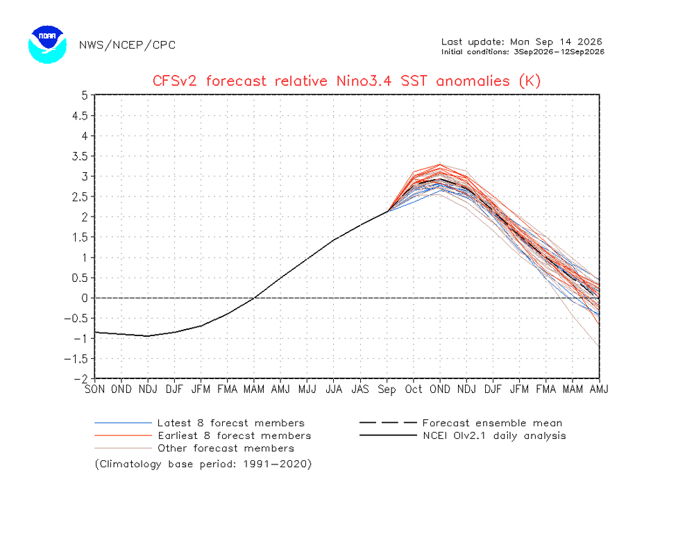
-
Scorching high of 94 after a low of 69. Hopefully we won't see anymore mid 90's.
- Today
-
 Cheap generic Viagra online: GetBelvion - Cheapest Sildenafil online
 -
Cooler air will return for the weekend. Saturday will be a dry day with partly sunny skies. Clouds will increase on Sunday. Highw will be in the upper 60s to around 70°. A rainy period will likely develop late Sunday. Periods of rain could continue into at least the middle of next week. Temperatures will remain unseasonably cool throughout next week. The ENSO Region 1+2 anomaly was +4.5°C and the Region 3.4 anomaly was +2.9°C for the week centered around September 9. For the past six weeks, the ENSO Region 1+2 anomaly has averaged +4.23°C and the ENSO Region 3.4 anomaly has averaged +2.65°C. The ongoing strong El Niño, will continue to strengthen through the mid-fall. The SOI was -34.52 today. The preliminary Arctic Oscillation (AO) was +2.661 today. Based on sensitivity analysis applied to the latest guidance, there is an implied near 63% probability that New York City will have a cooler than normal September (1991-2020 normal). September will likely finish with a mean temperature near 68.5° (0.7° below normal). Supplemental Information: The projected mean would be 0.5° above the 1981-2010 normal monthly value.
-
Buy Cialis online and Generic Cialis price Buy Tadalafil 20mg http://firstbaptistloeb.org/System/Login.asp?id=42182&Referer=https://menon36.shop Cialis 20mg price in USAand http://lenhong.fr/user/ezphuybjky/ Buy Tadalafil 10mg [url=http://referless.com/?http://menon36.shop/]buy cialis pill[/url] cheapest cialisor [url=http://www.1gmoli.com/home.php?mod=space&uid=1078145]buy cialis pill[/url] Buy Tadalafil 20mg
-
Buy Cialis online and Generic Cialis price Buy Tadalafil 20mg http://firstbaptistloeb.org/System/Login.asp?id=42182&Referer=https://menon36.shop Cialis 20mg price in USAand http://lenhong.fr/user/ezphuybjky/ Buy Tadalafil 10mg [url=http://referless.com/?http://menon36.shop/]buy cialis pill[/url] cheapest cialisor [url=http://www.1gmoli.com/home.php?mod=space&uid=1078145]buy cialis pill[/url] Buy Tadalafil 20mg
-
-

2026-2027 Record-breaking El Nino
bluewave replied to Stormchaserchuck1's topic in Weather Forecasting and Discussion
Depends on the year since the ridge location and intensity has been quite variable during previous super El Niño Octobers. This year is doing its own thing so far with the ridges stronger and further south than usual. We’ll have to see what the pattern looks like in early October since all we have now is a snapshot for the start of the month. -
Your bride is the blessing, Rob. I lost mine nearly nine years ago. I still sleep in our original wedding bed. ….. But not completely alone ….. my arms embrace a memory. As always …..
-
it was the most aggressive and now its less than inch i have noticed a trend. Euro will usually have something crazy....the GGEM or GFS will pick up on that craziness 1-2 days later but by the time they pick up on--the Euro is in no mode....and loses it lol
-
I was hoping that the rain would miss us, as some of the models were showing, and that we could get a week or two of sunny mid-seventies with 45-degree dews to get us on a good start with fall.
-
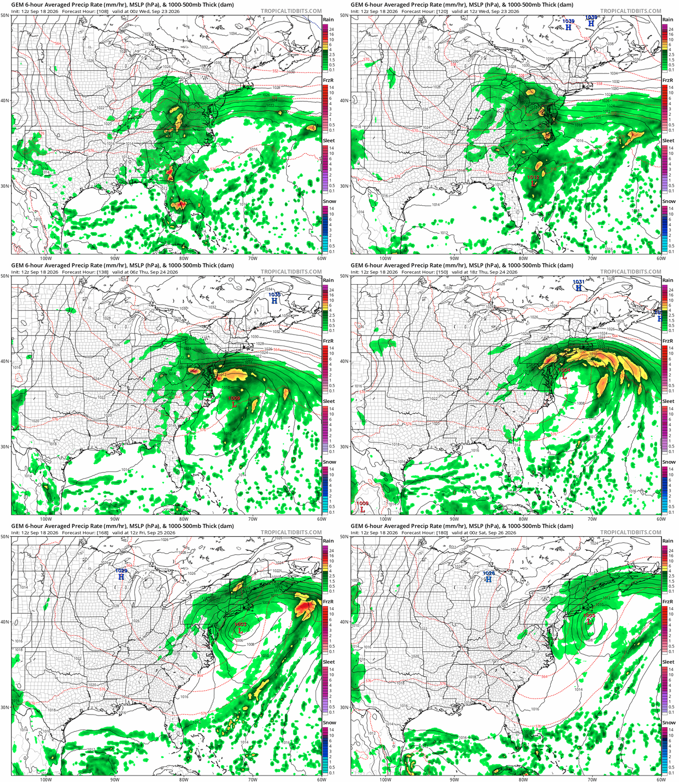
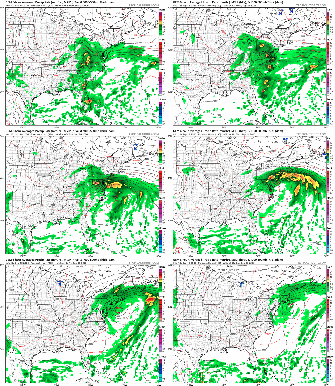
Y'all practicing? This sounds fun/interesting from WPC EFD this morning- ..Weather/Hazards Highlights... Upper-level support and a surface frontal system will lead to multiple rounds of moderate to heavy rain in the East next week. The placement of the heaviest amounts will vary from day to day, but generally the Mid-Atlantic looks like a focus. A relatively strong surface high for September should set up over Quebec and spill a cold air damming wedge south behind the front, yielding colder than average temperatures across the Northeast/Mid-Atlantic, with highs generally in the 60s and upper 50s Tuesday-Wednesday. This pattern will also allow for onshore winds and potentially some concern for coastal flooding for portions of the Northeast and Mid-Atlantic.
-
True. The coast is its own beast.
-

E PA/NJ/DE Autumn 2026 Obs/Discussion
Newman replied to PhiEaglesfan712's topic in Philadelphia Region
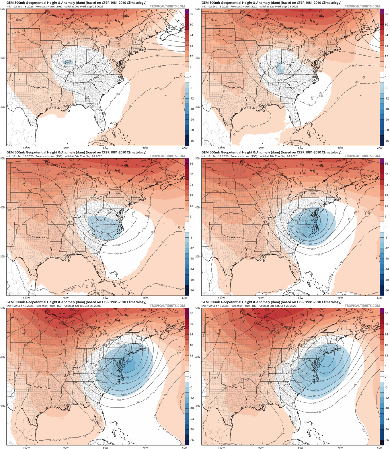
Canadian has a beautiful H5 pass with the progged coastal system next week. Too bad it's not January! Maybe a good sign for the winter, though? By the way, ever since the Canadian suite was upgraded in recent months it's been outperforming the Euro and GFS by quite a bit.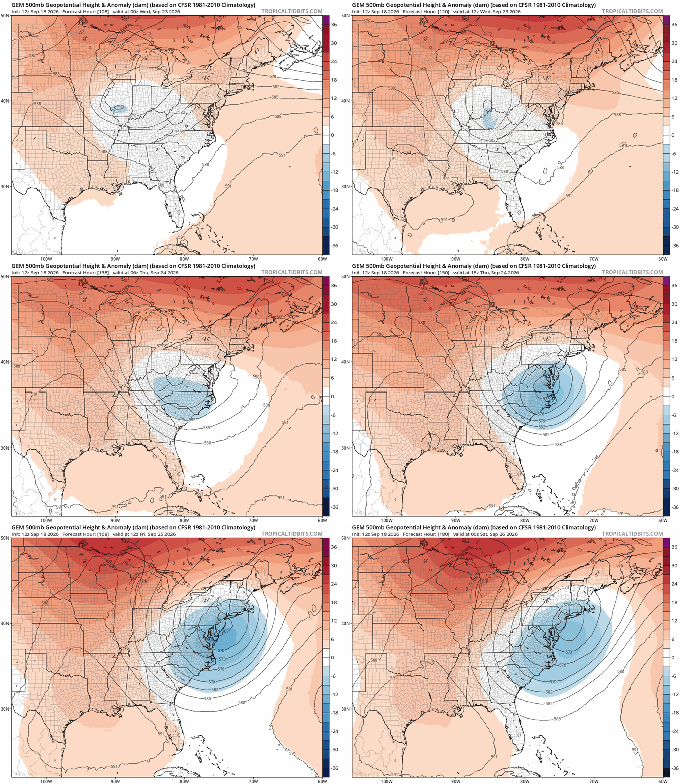
-
I don’t know about “ever increasing disaster”, but you must know that there have been some bad seasons since including 2008, 2012, and most of 2016-24. 2016-24 was one of the worst 9 year periods for the SE US overall. Fortunately 2025 as well as 2026 so far have given us a much needed break, especially after the horrible 2024. But that’s less than 2 seasons.
-

2026-2027 Record-breaking El Nino
roardog replied to Stormchaserchuck1's topic in Weather Forecasting and Discussion
I thought the Nino ridge south of Hudson Bay was not usually a Nino feature in October though. -
Hey Rich! .20 yesterday, 3.14 for the month, and a 2.5 hour power outage from around 10pm-12:30am last night. The power going out went unnoticed as the bride and I were already snoring but when it came back on the house 'coming back to life' got my attention and totally messed up my sleep cycle. Gorgeous weather here today and tomorrow before the gloom returns. My AC's getting uninstalled is on my list for tomorrow for those who are passionate about tracking such things. Happy feel-good football Friday! That's my report and GO IRISH!
-

Septorcher 2026 Discussion - Endless Summer
Typhoon Tip replied to Damage In Tolland's topic in New England
I would just caution that when models start backing in deep layer lows at 5-7 day leads, it's usually symbolic if not processing as though 'getting ready' to collapse one way or another. -

Central PA Summer 2026 Discussion/Obs Thread
MacChump replied to Voyager's topic in Upstate New York/Pennsylvania
kid's a freshman at PSU, going to see her this weekend and to our first game tomorrow, first real taste of fall looks like...about time!