All Activity
- Past hour
-
Its November. Give it time.
-
Overperformer
-

Central PA Fall Discussions and Obs
mahantango#1 replied to ChescoWx's topic in Upstate New York/Pennsylvania
1st trace of snow for the season here. -
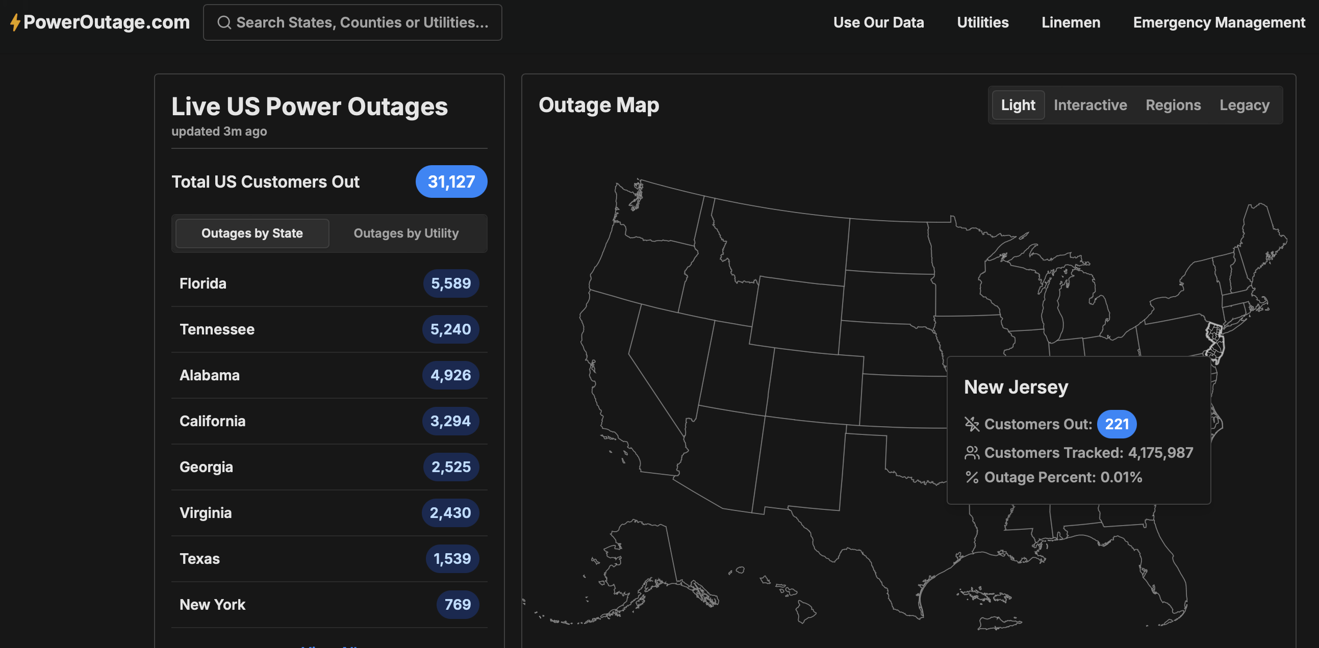
 Thanks for the obs... snow today NYC metro mainly before 2PM if its to occur. Wind gust tools too low throughout the NYC forum. Trying to avoid being wrong, but I expect gusts to reach 40 knots at least at some I95 corridor ASOS's this afternoon PHL-NYC-BDR. Gusts already higher than Blend Of Models and all tools. This is an anomalously strong trough passage. I add the power outage map from 625AM as a baseline check to look back at 4PM today to see if anything happened. I don't like crying wolf but I am a fan of the ECMWF wind gust tool and secondarily all other tools. The secondary's are all lower. I prepare for a buffeting this afternoon and possibly a downed tree branch-power outage.
-
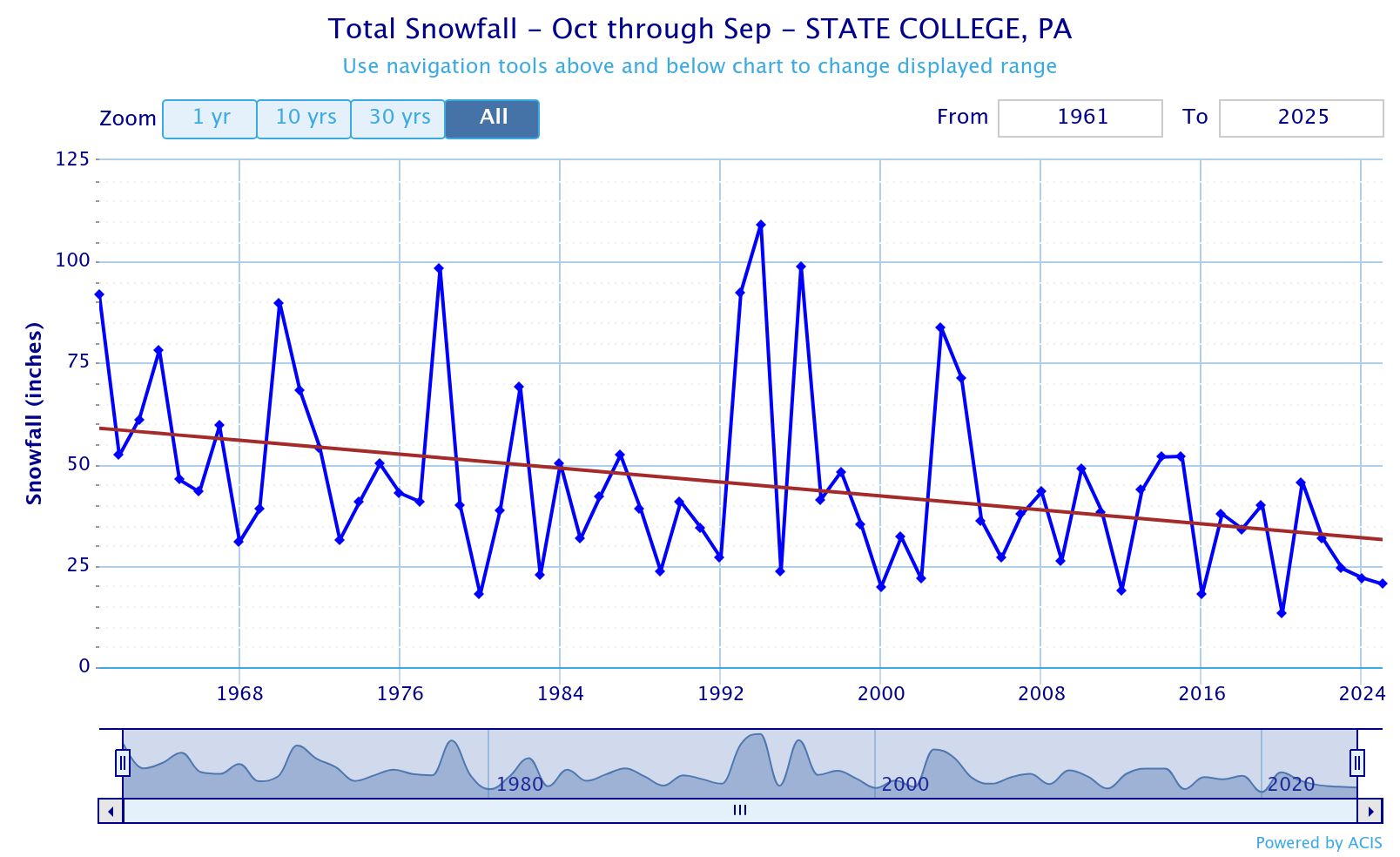
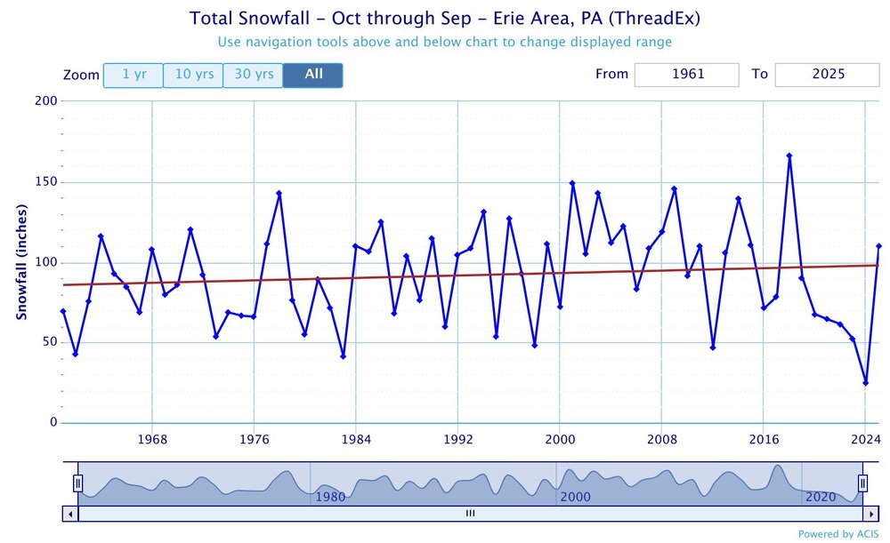
The snowbelt areas to the east of Cleveland have been holding their own with the shift in the storm tracks. Places like Erie, PA are positioned better for all the storm tracks through the Great Lakes. It’s areas to the east like State College that are on the warmer side of the storm tracks now which have seen a steep decline.

-
Just measured and I have around 3”. Best snow in the new house by far!
-

November 2025 general discussions and probable topic derailings ...
UnitedWx replied to Typhoon Tip's topic in New England
First flakes... and icy patches of the season on the way in to work in Granby and at the shop in Simsbury -
Hers the link for today
-

November 2025 general discussions and probable topic derailings ...
CoastalWx replied to Typhoon Tip's topic in New England
One day I’ll wake up and they’ll be something interesting to track outside of a 4K bear den. -
 Picked up 1" of snow. Currently cloudy 25.1
 -

2025-2026 Fall/Winter Mountain Thread
Buckethead replied to Buckethead's topic in Southeastern States
10° with diamond dust falling and 7.5" on the ground in Wolf. Sent from my SM-S908U using Tapatalk -
 First flakes of the season here in the bronx.
 -
Crystal clear sky this morning at 20.5. Impressive !
-
29 as the low so far. Was hoping for colder.
-

November 2025 general discussions and probable topic derailings ...
binbisso replied to Typhoon Tip's topic in New England
Flurries in myrtle beach s.c. broke record for the earliest snow. Old record nov 12, 2013. I would love to get a 13/14 type winter this year. Also first flakes here in the bronx atm -
You did it to yourself.
-

November 2025 general discussions and probable topic derailings ...
ineedsnow replied to Typhoon Tip's topic in New England
Just was going out to get a coffee.. and its very lightly SNOWING!!! FIRST FLAKES WOOOOO HOOOOOO!!!!! -
Central PA Fall Discussions and Obs
mahantango#1 replied to ChescoWx's topic in Upstate New York/Pennsylvania
Centre County 9-1-1 donretsSpo20g2t17gm4h66ghm9agl87tml5hf7m4igu6gm4m0imiu1fh039 · **I-80 TRAVELERS** 5:30 AM update: PennDOT is shutting I-80 west bound at Exit 178 (Lock Haven) and all drivers are to use the Brown Detour. Interstate 80 west bound at Exit 161 (Bellefonte) is going to be shut down for an extended period of time. Please plan and adjust your travels accordingly. -
Verbatim, it’s showing a -PNA/RNA. If it’s correct with the -EPO/-AO/-NAO, then the entire northern tier of the lower 48 would get cold….assuming the EPO ridge gets poleward enough to tap cross-polar flow
-
FWIW
-

November 2025 general discussions and probable topic derailings ...
jsw replied to Typhoon Tip's topic in New England
Now, 31/25. We got about a half inch of rain for the duration. Came down in buckets for about a half hour yesterday evening. Good to see some snow high up and up North! Mountains are also blowing snow like crazy. My favorite time of year--first snow to end of March. - Today
-
Furries here in the bronx
-

November 2025 general discussions and probable topic derailings ...
SnoSki14 replied to Typhoon Tip's topic in New England
Good luck with that dude. I see a very similar pattern to last year. And I wouldn't be shocked if the deep south got smoked due to some suppressed cut off while northern areas get shut out again. You will not get a storm unless the Pacific jet from hell abates. -
We do know Vernon NJ has measurable melted snowfall last 3 hours per the NJ Climate network. Also Roanoke 41 KT recently. snow showers and wind coming for at least some in our NYC subforum.
-
These snow obs should be going on the specific thread for today. Thanks