All Activity
- Past hour
-
Ukie also close. Huge west shift from 12z .
-

Central PA Winter 25/26 Discussion and Obs
NepaJames8602 replied to MAG5035's topic in Upstate New York/Pennsylvania
Honestly, at around 5 days out, this is a good look. That is one powerhouse being shown. I'm sure some wild solutions are to come on these models. Great trends today. -
 Bright side: new personal record Downside: porked ratio by Arctic Hounds... Sent from my SM-S166V using Tapatalk
 -

Richmond Metro/Hampton Roads Area Discussion
chris624wx replied to RIC Airport's topic in Mid Atlantic
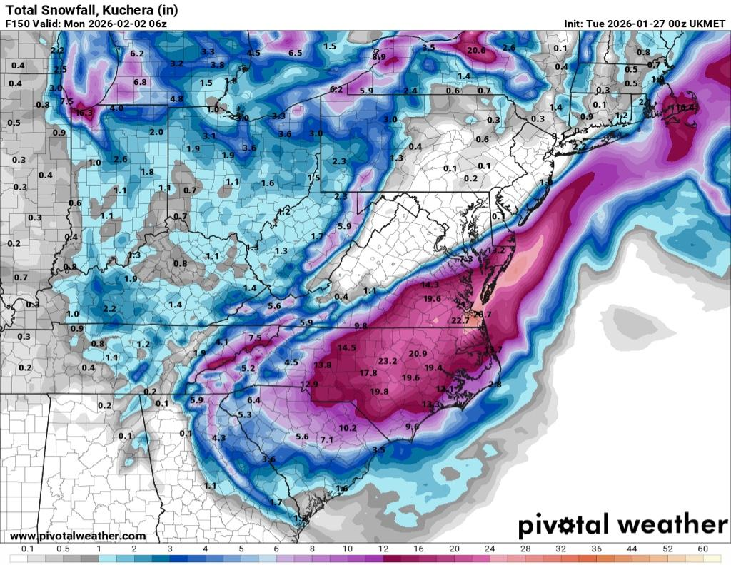
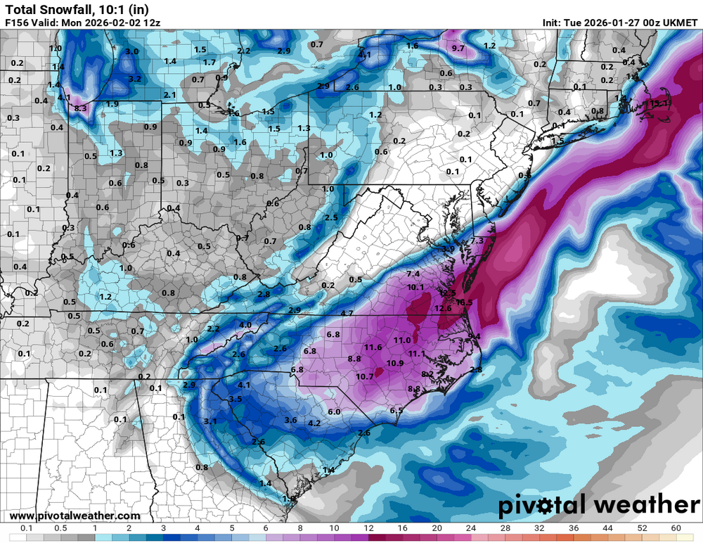
Kuchera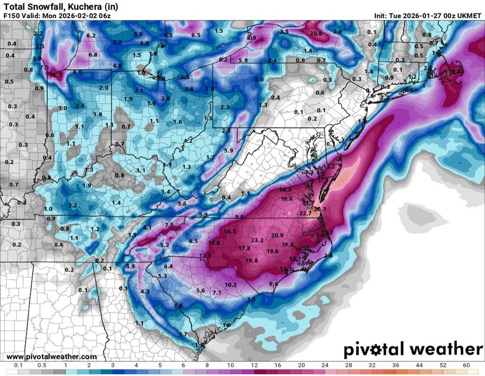
-

The “I bring the mojo” Jan 30-Feb 1 potential winter storm
lilj4425 replied to lilj4425's topic in Southeastern States
No need to cliff dive. I got this. I bring the mojo. -

Pittsburgh/Western PA WINTER ‘25/‘26
colonel717 replied to Burghblizz's topic in Upstate New York/Pennsylvania
All models tonight show trough becoming more west oriented for the weekend storm. Still not affecting us but this has been our winter and it just wants to snow here so I wouldn't be surprised if things trend our way to at least a 6+ storm -

Possible coastal storm centered on Feb 1 2026.
78Blizzard replied to Typhoon Tip's topic in New England
Not only was the GEFS west of the 18z run, the members are more consolidated to the west. -

Possible coastal storm centered on Feb 1 2026.
40/70 Benchmark replied to Typhoon Tip's topic in New England
No. -
Such a Niña map
-
 We had to scratch and claw and snow all day and all night to get over the hump. 10.1" at WXW2. Low spot in the region, but no complaints here. Just glad we got double digits. Incredible snow depth. So happy for everyone that got crushed.
 -
Its not 'last minute'. Look at the orientation of the ridge over S Canada north of the GLs- it folds over- essentially an anticyclonic wave break
-

The “I bring the mojo” Jan 30-Feb 1 potential winter storm
NYweatherguy replied to lilj4425's topic in Southeastern States
Atlanta/NE GA is back in the game. Let's hope the trend continues. We have four days before the action starts, so a lot can happen. -
As a lover of digital snow I want to cry
-
Some progress tonight. Hopefully we see more tomorrow.
-
Everyone in OCMD and Richmond should make a midnight run to the grocery store to stock up on supplies
-

The “I bring the mojo” Jan 30-Feb 1 potential winter storm
WiseWeather replied to lilj4425's topic in Southeastern States
. -
We saw the effect of trapped moisture with just enough lift last night and this morning..now place that DGZ near the surface and instead of mist you get nickles and dimes
-

Possible coastal storm centered on Feb 1 2026.
WinterWolf replied to Typhoon Tip's topic in New England
Geek, this may not even get up here. So no maps until we’re sure this is coming up, and is close enough for a good hit. Tomorrow is not the time for a snow map. Chill for a bit. If it becomes more imminent…post your maps then. -

Central PA Winter 25/26 Discussion and Obs
anotherman replied to MAG5035's topic in Upstate New York/Pennsylvania
Canadian tantalizingly close. -

The “I bring the mojo” Jan 30-Feb 1 potential winter storm
HWY316wx replied to lilj4425's topic in Southeastern States
For the love... you guys are gonna suck me back into this... -

The “I bring the mojo” Jan 30-Feb 1 potential winter storm
BornAgain13 replied to lilj4425's topic in Southeastern States
This is really gonna make me stay up for the Euro... -
January 25-26th, 2026 Final Storm Totals
WxWatcher007 replied to The 4 Seasons's topic in New England
Finished with 15.5" in East Hartford, and I'm almost certain it's an undercount. Oh well. Biggest storm since moving back to CT. Also, nobody cares but finished with 10.1" in Barrow, I mean SLK, @The 4 Seasons -
Yeah, it’s a Norfolk special like the CMC. But at 12Z it was almost completely OTS. Progress
-

The “I bring the mojo” Jan 30-Feb 1 potential winter storm
Ravens94 replied to lilj4425's topic in Southeastern States
Pretty much all the models tonight have a coastal-95 snowstorm. The icon being the outlier but if you blend what's out there so far everything is in relative agreement. Its nice to have a straight up MIller A and ultimately if the euro comes in similar it will be model agrement other then a few small changes to come.