All Activity
- Past hour
-
still getting some of the best rates down here of the day… completely unexpected! .
-
I would actually just give up to be honest. What's the point? You definitely live in a peculiar place that always gets the shaft.
-

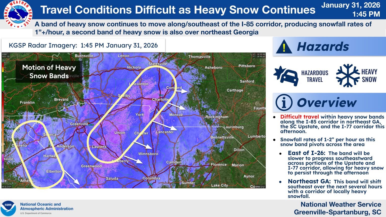
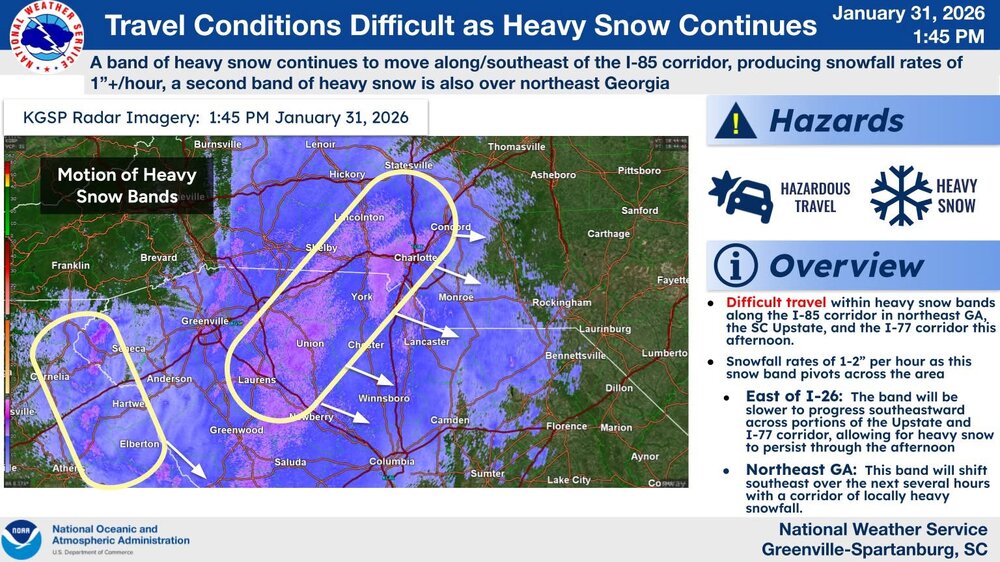
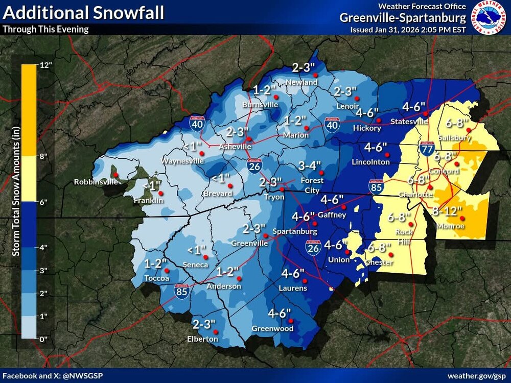
January 30th- Feb 1st ULL and coastal storm obs
CentralNC replied to JoshM's topic in Southeastern States
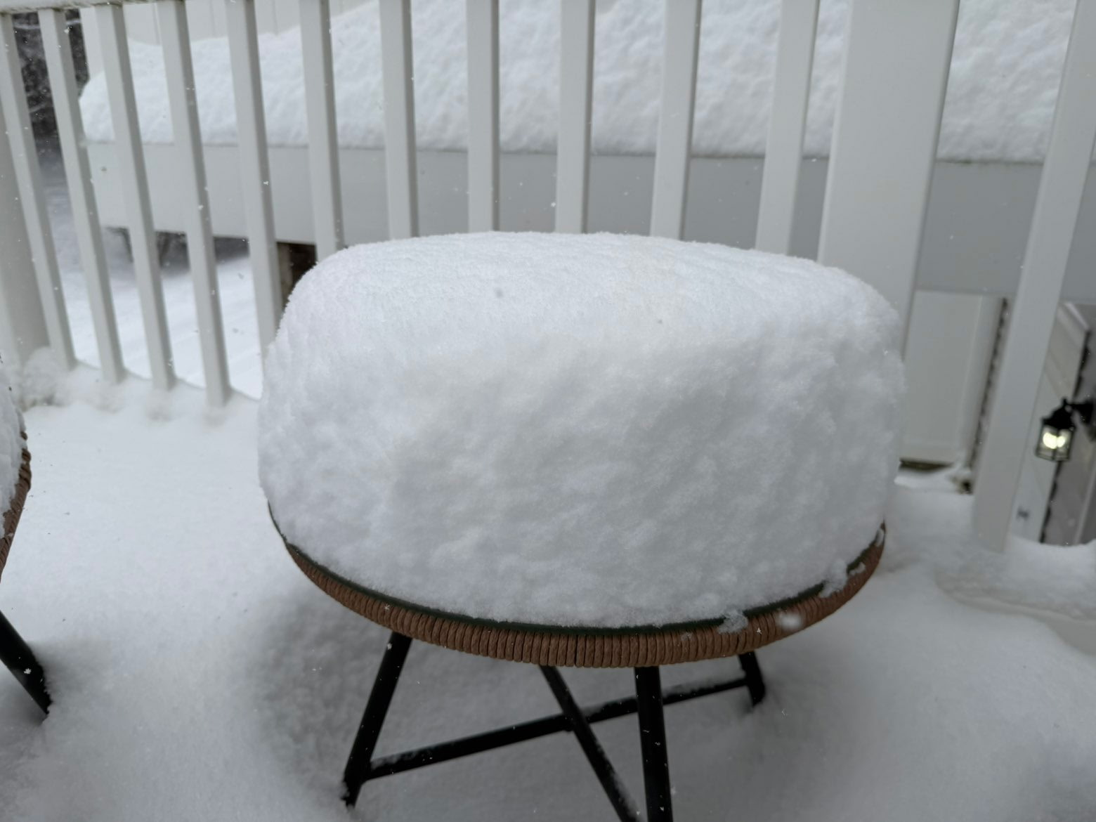
Solid 5 inches in Lewisville/Clemmons area at 2:15. Still moderate snow and 19 degrees -
BDR'S reports come up as Official NWS Obs. I assume that means they have an observer on site? Seems they have a good observer as I work in the area all the time and they seem spot on.
-

January 30th- Feb 1st ULL and coastal storm obs
NCSUGrad replied to JoshM's topic in Southeastern States
Huntersville, NC
-

Jan 30th-February 1st 2026 Arctic Blast/ULL Snow OBS Thread.
TellicoWx replied to John1122's topic in Tennessee Valley
Easily 2-3" per hr snow rates right now -

January 30th- Feb 1st ULL and coastal storm obs
franklin NCwx replied to JoshM's topic in Southeastern States
Just past 10" in Franklin! Still snow but flakes are so fine. Down to 16 already and winds are ripping! -
No one one here and I repeat no one can give the Raleigh crowd sh*t after today if we cliff dive early on storms. This is actually absurd
-
You know i had to laugh at that,although there is precip where there shouldn't be. Lower Cloud deck should be moving in soon off the ocean.
-

February 2026 Medium/ Long Range Discussion: Buckle Up!
Terpeast replied to Weather Will's topic in Mid Atlantic
Yep, both ai and nwp euro ens show brief connection then right back to cold. We don’t even go AN that much on the “warmest” day, and 11-15 day forecasts have still been biased too warm -

E PA/NJ/DE Winter 2025-26 Obs/Discussion
RedSky replied to LVblizzard's topic in Philadelphia Region
average depth 10.50" 22F -
https://x.com/convchronicles/status/2017676414120825160?s=46&t=LVg8BRWCh1zZb6F_t95EVg .
-

Jan 30th-February 1st 2026 Arctic Blast/ULL Snow OBS Thread.
Wurbus replied to John1122's topic in Tennessee Valley
Feels like I'm in a snow globe right now -

-

January 30th- Feb 1st ULL and coastal storm obs
sarcean replied to JoshM's topic in Southeastern States
Coming down absolutely dumping in Lake Wylie area of Charlotte. 5 inches so far and has to be coming down an inch per hour right now. -
Nice
-

The “I bring the mojo” Jan 30-Feb 1 potential winter storm
lilj4425 replied to lilj4425's topic in Southeastern States

-
Channel13 future radar looks good for the southside around 6pm. 2-4?
-

Jan 30th-February 1st 2026 Arctic Blast/ULL Snow OBS Thread.
GBOVolz replied to John1122's topic in Tennessee Valley
If someone can gif that gif and post it here that would be great . -
legendary in the worst way. i've never been screwed so hard lmao
-

January 30th- Feb 1st ULL and coastal storm obs
NCSU_Pi replied to JoshM's topic in Southeastern States
Finally, some flakes in the Swift Creek area. -

Arctic Hounds Unleashed: Long Duration Late January Cold Snap
DavisStraight replied to WxWatcher007's topic in New England
I'm 20 up on the Maine Coast. -

January 30th- Feb 1st ULL and coastal storm obs
KrummWx replied to JoshM's topic in Southeastern States
still not a single flake in midtown raleigh -

January 30th- Feb 1st ULL and coastal storm obs
Isopycnic replied to JoshM's topic in Southeastern States
-
Jan 30th-February 1st 2026 Arctic Blast/ULL Snow OBS Thread.
GBOVolz replied to John1122's topic in Tennessee Valley
It looks to me that the snow bands are curving towards the SW for some reason. Is this wind shear or is there a high pressure wrapping the snow around it? I can’t get the gif to load so I tweeted the gif to link it here. https://x.com/powellvolz/status/2017677102644945245?s=46&t=LVg8BRWCh1zZb6F_t95EVg .