All Activity
- Past hour
-
I’m waiting on @uofmiamifor official measurement but much of the north shore of LI central Nassau east over a foot for December. Not too shabby
-
https://x.com/webberweather/status/2004901998056092135?s=61&t=jtYSAZghIHxEA6K1a8OFsw
-
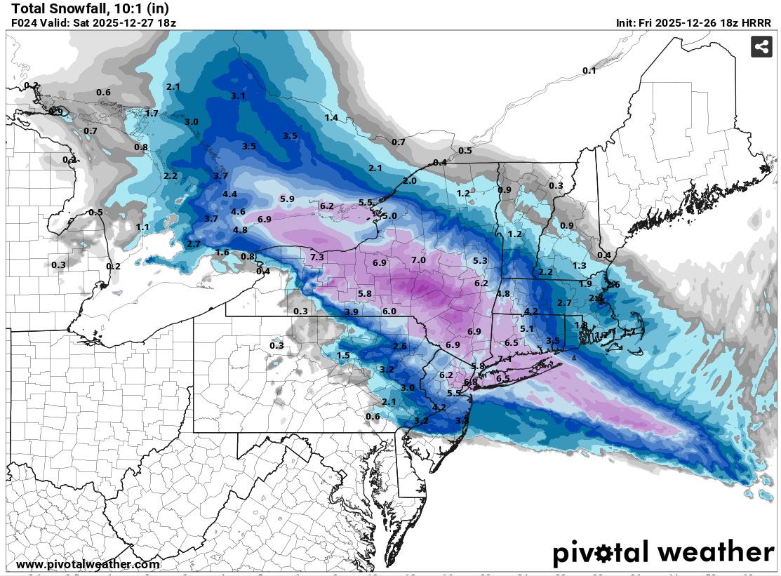
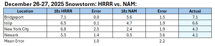
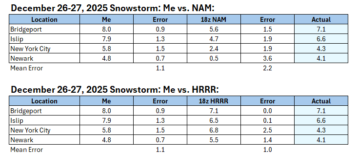
18z NAM vs. 18z HRRR: Here's how I fared against the two models: Final Accumulations: Bridgeport: 7.1" Islip: 6.6" New York City-Central Park: 4.3" New York City-JFK Airport: 4.1" New York City-LaGuardia Airport: 4.1" Newark: 4.2" The low end of the 4"-8" idea worked out. The loss of precipitation from the weak lift that developed in the spacing between the surface and mid-level lows likely deprived the region of several inches of snow. It also allowed for some intrusion of sleet into the greater New York City area for a time until the lift improved.
-
Ended up with 5.5 inches here although very light snow still falling so I can't give up on 6 yet. A bit of an underperformer here.
-

Wounded Duck Strikes Back: Dec 26 & 27th Winter Storm Obs
WinterWolf replied to WxWatcher007's topic in New England
Not bad at all. -
Yea some steady light snow in the UWS, maybe we squeeze out an extra tenth or two
-
655 NOUS41 KOKX 271249 PNSOKX CTZ005>012-NJZ002-004-006-103>108-NYZ067>075-078>081-176>179-280049- Public Information Statement National Weather Service New York NY 749 AM EST Sat Dec 27 2025 ...SNOWFALL REPORTS... Location Amount Time/Date Provider ...Connecticut... ...Fairfield County... 4 NNW New Fairfield 9.1 in 0409 AM 12/27 Trained Spotter Bridgeport Airport 7.1 in 0700 AM 12/27 Official NWS Obs 2 ENE New Canaan 7.1 in 0528 AM 12/27 Trained Spotter Bethel 6.5 in 0700 AM 12/27 Emergency Mngr 4 SSE Easton 6.2 in 0600 AM 12/27 Public 1 W Stamford 5.9 in 0605 AM 12/27 Trained Spotter 1 NNW Stamford 5.7 in 0100 AM 12/27 Trained Spotter ...Middlesex County... Clinton 8.0 in 0645 AM 12/27 Broadcast Media 1 SW Westbrook 7.7 in 0240 AM 12/27 Trained Spotter ...New Haven County... 1 NNW Meriden 9.0 in 0350 AM 12/27 Trained Spotter 1 ENE North Haven 7.7 in 1220 AM 12/27 Trained Spotter 2 NW Hamden 7.3 in 0647 AM 12/27 Public 4 SSE Durham 7.1 in 0200 AM 12/27 Public 3 ENE Branford 6.5 in 0647 AM 12/27 Public 3 ENE Branford 6.4 in 1201 AM 12/27 Public 1 NW Ansonia 6.0 in 0531 AM 12/27 Public ...New London County... 5 SSE Salem 7.0 in 0603 AM 12/27 Public New London 6.5 in 1139 PM 12/26 Trained Spotter Ledyard Center 5.5 in 0100 AM 12/27 Trained Spotter ...New Jersey... ...Bergen County... 1 S River Edge 3.3 in 0720 AM 12/27 Public 2 NNE Franklin Lakes 3.2 in 0138 AM 12/27 Public ...Essex County... 2 NE Springfield 3.0 in 0400 AM 12/27 Public 1 NW Newark 2.3 in 1226 AM 12/27 Public ...Hudson County... Harrison 4.0 in 0442 AM 12/27 CO-OP Observer Hoboken 3.9 in 0700 AM 12/27 Trained Spotter ...Union County... Newark Airport 4.2 in 0700 AM 12/27 Official NWS Obs 1 NW Cranford 3.0 in 0717 AM 12/27 Public 1 NE Union 3.0 in 0200 AM 12/27 Public ...New York... ...Bronx County... 1 NNE Fordham 4.3 in 0400 AM 12/27 Public ...Kings County... 1 SSE Williamsburg 4.3 in 0715 AM 12/27 Public 1 N Bay Ridge 3.1 in 0603 AM 12/27 Public ...Nassau County... Massapequa 4.1 in 0700 AM 12/27 Amateur Radio 1 N Centre Island 4.0 in 0529 AM 12/27 Public 1 SW Levittown 4.0 in 0202 AM 12/27 Public Carle Place 3.1 in 0645 AM 12/27 Amateur Radio 1 SW Elmont 2.0 in 1250 AM 12/27 Trained Spotter ...New York (Manhattan) County... Central Park 4.3 in 0700 AM 12/27 Official NWS Obs ...Orange County... 2 SSW Stewart Airport 5.7 in 0724 AM 12/27 Public 2 E Highland Mills 5.2 in 0130 AM 12/27 Public 2 NW Stewart Airport 5.0 in 0628 AM 12/27 Amateur Radio Monroe 5.0 in 0500 AM 12/27 Trained Spotter 2 SSW Stewart Airport 5.0 in 1212 AM 12/27 3 WNW Warwick 4.0 in 0603 AM 12/27 Trained Spotter ...Putnam County... 2 W Putnam Valley 5.7 in 0605 AM 12/27 NWS Employee ...Queens County... 1 WSW Howard Beach 4.6 in 0701 AM 12/27 Broadcast Media NYC/JFK 4.1 in 0700 AM 12/27 Official NWS Obs NYC/La Guardia 4.1 in 0700 AM 12/27 Official NWS Obs ...Suffolk County... Babylon 7.5 in 0645 AM 12/27 Amateur Radio Orient 7.5 in 0615 AM 12/27 Trained Spotter North Patchogue 6.8 in 0109 AM 12/27 Public Islip Airport 6.6 in 0700 AM 12/27 Official NWS Obs Upton (NWS Office) 6.5 in 0700 AM 12/27 Official NWS Obs Stony Brook 5.8 in 0700 AM 12/27 Trained Spotter 1 WNW Sound Beach 5.8 in 0700 AM 12/27 Public 2 E Flanders 5.8 in 1120 PM 12/26 Public 1 SSE Bohemia 5.6 in 0550 AM 12/27 Trained Spotter 2 SE Ridge 5.6 in 1159 PM 12/26 NWS Employee Deer Park 5.3 in 0600 AM 12/27 Trained Spotter 1 WSW Poquott 5.2 in 0425 AM 12/27 NWS Employee Sayville 5.1 in 0700 AM 12/27 NWS Employee 1 ESE East Patchogue 5.1 in 0541 AM 12/27 NWS Employee 1 SSE Bohemia 4.7 in 1205 AM 12/27 Public 2 S Commack 4.5 in 0145 AM 12/27 Public 1 N Smithtown 4.3 in 1200 AM 12/27 Trained Spotter Stony Brook 4.3 in 1155 PM 12/26 Trained Spotter 1 ENE Commack 4.0 in 1140 PM 12/26 Broadcast Media 1 E Kings Park 3.6 in 1259 AM 12/27 Public Medford 3.5 in 0723 AM 12/27 Amateur Radio ...Westchester County... Armonk 6.4 in 0200 AM 12/27 Trained Spotter 2 ENE Peekskill 6.1 in 1200 AM 12/27 Trained Spotter 1 E Pelham Manor 2.8 in 0736 AM 12/27 Public
-

E PA/NJ/DE Winter 2025-26 Obs/Discussion
Kevin Reilly replied to LVblizzard's topic in Philadelphia Region
2009-2010 think the last time. -

Wounded Duck Strikes Back: Dec 26 & 27th Winter Storm Obs
weatherwiz replied to WxWatcher007's topic in New England
Exactly 10” on the season so far. Not bad for December. -
4.3” total same as 12/14. 8.6” season total so far @The 4 Seasons
-
Roads seem fine but everything else is pretty icy IMBY. Deck/grass is all ice. Poor dogs were sliding their way out to the yard this morning
-
About 2.5". After last night I'll take it
-
Wounded Duck Strikes Back: Dec 26 & 27th Winter Storm Obs
WinterWolf replied to WxWatcher007's topic in New England
Good storm for a lot of us. You and Don were on this, and reeled her right in . -
Some areas aren't as bad of a bust as others. I think Mt. hollys final for my area was 4-7. Aaaaaaand I got a .25" of sleet so yea some parts it busted and busted pretty bad.
-
Just about 3” - I was 0.7 off my guess for MBY
-

Central PA Winter 25/26 Discussion and Obs
mitchnick replied to MAG5035's topic in Upstate New York/Pennsylvania
I've got lt snow here. Anything up north of me? -
Still a steady lite snow falling, enough to recoat shoveled sidewalks. Temp down at 23°.
-
January 2026 regional war/obs/disco thread
WinterWolf replied to Baroclinic Zone's topic in New England
Way to go Bob…let’s make it a Jammin January for SNE/New England. -

Wounded Duck Strikes Back: Dec 26 & 27th Winter Storm Obs
Sey-Mour Snow replied to WxWatcher007's topic in New England
Depth is 6.0” we have an additional inch where I shoveled before I went to bed so I guess 7.0” will do it. -

Wounded Duck Strikes Back: Dec 26 & 27th Winter Storm Obs
snowman21 replied to WxWatcher007's topic in New England
Best December since '09 I'd say for combo of snow and cold. -
4.0 inches exactly at my station here in Sheepshead Bay Brooklyn.
-
We do now have a few trackable events in the Jan 5-12 period (plus the NYD clipper). Even though they’re not showing what we want right now, there’s a lot of time for these to trend in our favor. It’s definitely not a shit the blinds pattern, but we need some luck on our side.
-

Wounded Duck Strikes Back: Dec 26 & 27th Winter Storm Obs
MJO812 replied to WxWatcher007's topic in New England
Central Park 4.3 inches Biggest storm in years -
Central Park 4.3 inches Biggest storm in years
-
Wounded Duck Strikes Back: Dec 26 & 27th Winter Storm Obs
WinterWolf replied to WxWatcher007's topic in New England
Yes sir. That was good for the (snow weenie) soul.