All Activity
- Past hour
-

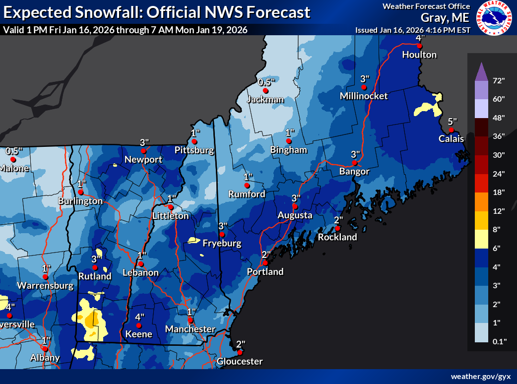
January 2026 Medium/Long Range Discussion
RickinBaltimore replied to snowfan's topic in Mid Atlantic
Ahem. -
18z GFS a bit of a step back, depending on location. A little worse for me, but still close to 2 inches, but better for S DE, damn near 4". I might consider a trip to Rehoboth since I'm off for MLK day.
-

Another Coating of Snow Saturday - "It's all we Got"
CoastalWx replied to Sey-Mour Snow's topic in New England
This BS event is your only hope now. -

First Legit Storm Potential of the Season Upon Us
ORH_wxman replied to 40/70 Benchmark's topic in New England
The Canadians and skynet versus everyone else. Maybe we can pull a Miracle on Ice 1980 out of our ass....this winter has been about on par with '79-'80. -

Storm potential January 17th-18th
Brian5671 replied to WeatherGeek2025's topic in New York City Metro
yep well east for the 2nd batch -

January 2026 Medium/Long Range Discussion
Scarlet Pimpernel replied to snowfan's topic in Mid Atlantic
We're on the Harry Potter Knight Bus...ahhhhhhhh! -
The recon data coming in, i still remember the bad data “claim” 48 hours out from Boxing Day, then 0z was just as west, and watches came out by 3am lol
-
Gfs just folded
-
Storm potential January 17th-18th
Brian5671 replied to WeatherGeek2025's topic in New York City Metro
odd but maybe it sees a heavier patch of snow-but yeah I'm skeptical given temps -
The HRRR and 18z 3k NAM are all snow for NE TN, albeit very light amounts. The 18z RGEM is rain. When is onset for this?
-
I’ll do it for the next 20 min then I have to pass on the baton. Nothing noteworthy up to Jan 20 yet.
-

Storm potential January 17th-18th
EastonSN+ replied to WeatherGeek2025's topic in New York City Metro
10 to 1 so fwiw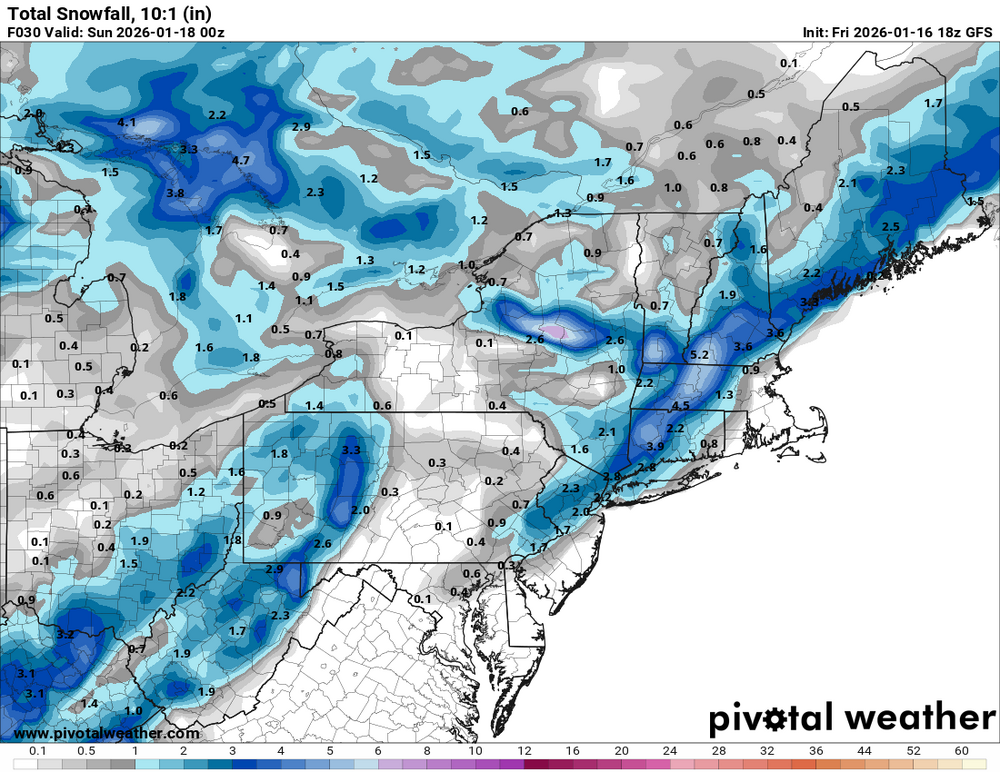
-

Another Coating of Snow Saturday - "It's all we Got"
WxWatcher007 replied to Sey-Mour Snow's topic in New England
Welcome to all the posters that are now joining the weekend storm thread -
My skies are clear for sure. It hasn't been warm today at all. When I went running this morning, it was 12 degrees I think...one of the top 5 coldest running mornings(this winter) for me. Yesterday was by far the worst. I made the mistake of running down on the river(you know where it is...NI).
-
First Legit Storm Potential of the Season Upon Us
ORH_wxman replied to 40/70 Benchmark's topic in New England
Tomorrow looks like dogshit for anyone east of FIT-DXR line. -
Based on precip shields, I think gfs and aigfs are converging closer to each other. Whether it’s correct or not, idk. We’ll get better clues at 00z when new upper air data is ingested.
-
Look at how low the dew points are too. That has to be good for at least onset sleet until the dewpoint rises above freezing. I don’t know I’m grasping at straws here but seen that happen many times.
-

Another Coating of Snow Saturday - "It's all we Got"
dryslot replied to Sey-Mour Snow's topic in New England
LFG!
-

Another Coating of Snow Saturday - "It's all we Got"
Damage In Tolland replied to Sey-Mour Snow's topic in New England
Tomorrow can toss -
Once again = RGEM map doesn't make sense especially with the crazy spread of amounts along the coast and an inch and a half in Warren/ Sussex County NJ
-
Stevie Wonder.
-

Jan 17-18 Sunday Funday Storm
gamecockinupstateSC replied to NorthHillsWx's topic in Southeastern States
Well, the GFS is much improved for the Upstate and Midlands. Look at S-Central GA.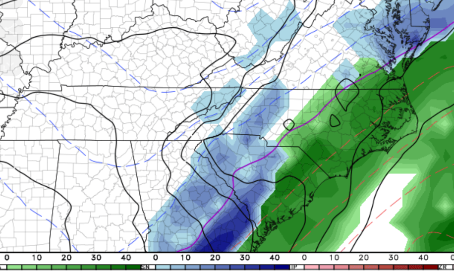
-
High of 35 and low of 19 No sun effect and with that low temp light snow will stick almost instantly overnight
-
Who’s driving this damn bus?
-
The current 500 pattern did not get can kicked. It arrived on Jan 12th as we noted for at least a couple of weeks prior that it would. I don't think anyone is on a sugar high...The upcoming weekend event was never real as there was a blatant error on GFS modeling where it connected w/ an eastern Pac storm. However, they still had to send hurricane hunters out to make sure. But folks are allowed to get excited. We only live once. And can-kicking is just part of it in the Upper South.