All Activity
- Past hour
-
Hang tough! Don't bail yet!
-

Possible coastal storm centered on Feb 1 2026.
dryslot replied to Typhoon Tip's topic in New England
I'm squinting to find them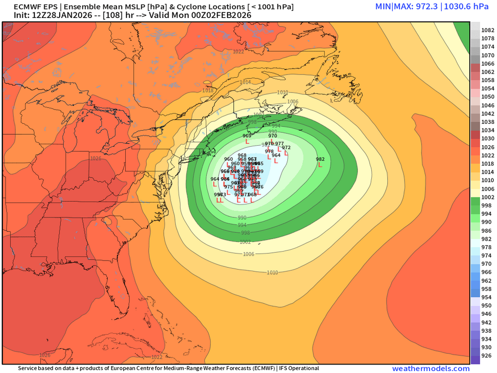
-

Possible coastal storm centered on Feb 1 2026.
ma blizzard replied to Typhoon Tip's topic in New England
can't wait for that inevitable run of the NAM that shows a region wide blizzard followed by a clean whiff within a couple model cycles -

The “I bring the mojo” Jan 30-Feb 1 potential winter storm
Buddy1987 replied to lilj4425's topic in Southeastern States
@BornAgain13 was fun while it lasted up this way my man.. 2-4" would be a win at this point. I don't trust GFS whatsoever. Idc how consistent that thing has been. -

The “I bring the mojo” Jan 30-Feb 1 potential winter storm
eyewall replied to lilj4425's topic in Southeastern States
I never thought I would see panic for RDU weenies because the Euro drops 9-10 instead of 28 -

Possible coastal storm centered on Feb 1 2026.
ineedsnow replied to Typhoon Tip's topic in New England
-
 images.mp4
 -
You in district 13?
-

Possible coastal storm centered on Feb 1 2026.
Kitz Craver replied to Typhoon Tip's topic in New England
Like it’s been said many times, EOR looks like they are in the game. OTR/WOR not so much. It’s the peeps out east who are like, why are we canceling?! Lol -
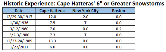
The NBM is showing a situation that would be historically unique. 1/28 13z NBM: Assuming Cape Hatteras receives 6" or more snowfall, the odds of amounts approaching 6" in New York City would likely be very low. To date, none of the 6" or greater snowstorms in Cape Hatteras saw more than 2" in New York City. While changes remain possible at the current lead time, there is no overwhelming evidence to support the historically unique solution shown on the NBM at present.
-
Bring snow, we could use some here. In town, 3 to 5 inches. At ski resort, they say much more, must be snow they made because on the ground away from the resort it looks like 8" to maybe a foot. And it's recent powder on top of a frozen old crust. I haven't seen so little amounts of snow here in the seven winters we have lived here, normal maximum snow depth here is 30" in town and 45" in the hills and is around from mid-January to early March normally.
-

The “I bring the mojo” Jan 30-Feb 1 potential winter storm
WXNewton replied to lilj4425's topic in Southeastern States
The only model that didn't follow the further east trend was the GFS AI, I wonder how it's been performing? -

Possible coastal storm centered on Feb 1 2026.
40/70 Benchmark replied to Typhoon Tip's topic in New England
Yea, I agree.....if I'm wrong, I'll admit...just had to in the other direction last week...but not there yet. This is precarious. -
The “I bring the mojo” Jan 30-Feb 1 potential winter storm
eyewall replied to lilj4425's topic in Southeastern States
It is not a rug pull as the overall consistency is there. A lot is going to depend exactly where the deformation band sets up and that is going to be a tough call almost until game time. Some of the amount shifts are likely because of this. -

The Jan 31 Potential: Stormtracker Failure or 'Tracker Trouncing
Solution Man replied to stormtracker's topic in Mid Atlantic
It’s easy, 0 - 0 =0 -

2025-2026 Fall/Winter Mountain Thread
CheoahBald1 replied to Buckethead's topic in Southeastern States
Yeah I think you’re right. I actually work way more outta Jackson, Macon , Haywood co. . -

2025-2026 Fall/Winter Mountain Thread
franklin NCwx replied to Buckethead's topic in Southeastern States
Im sure yall stay busy on snowbird and the skyway. I thought they contracted that out to Adams? -

Pittsburgh/Western PA WINTER ‘25/‘26
RitualOfTheTrout replied to Burghblizz's topic in Upstate New York/Pennsylvania
Yeah, we are toast on this one I'd say, barring some crazy fail of all guidance. Honestly, it's a terrible waste of potential for most of the east. Outside of some light clipper type systems, I think we need to get past the brutal cold this weekend and see if anything can spin up as it relaxes a little bit. -
The “I bring the mojo” Jan 30-Feb 1 potential winter storm
WXNewton replied to lilj4425's topic in Southeastern States
Yeah, I was more focusing on the footprint of the storm, I have to look closely at it to make sure it wasn't the run before lol. -

The Jan 31 Potential: Stormtracker Failure or 'Tracker Trouncing
rjvanals replied to stormtracker's topic in Mid Atlantic
For DC looks like 75% misses 20% smaller hits in the 1-3 range and one bigger hit -
Possible coastal storm centered on Feb 1 2026.
40/70 Benchmark replied to Typhoon Tip's topic in New England
I would hold off on the CC-gradient saturation victory laps....I get that was somewhat facetious, but honestly...lots more to be ironed out here. -

Possible coastal storm centered on Feb 1 2026.
bristolri_wx replied to Typhoon Tip's topic in New England
Considering the atmospheric scenario and the number of moving parts, there's a higher risk for this than usual on a 4 day forecast. I truly wouldn't dismiss any scenario for another 48 hours. -
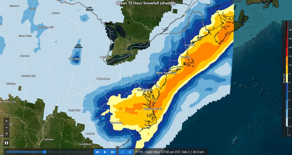
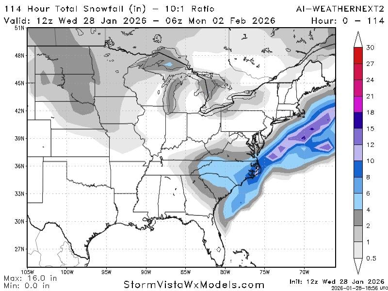
that’s 10:1 ratio. Likely to be closer to 20:1
- 92 replies
-
- 1
-

-
- extreme cold
- snow
- (and 1 more)
-
Maybe it’s the GFS that does something different for 2 of its runs. .
-
 You should know I'm a median lover! Just wasn't out yet. Lock it up


