All Activity
- Past hour
-
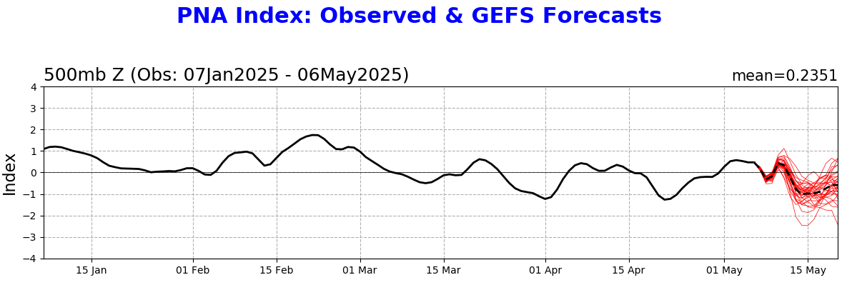
Where's @Typhoon Tip This seems like an impressive dip in the PNA for mid-May, no? EPS is even more negative too

-
Yeah certainly zero need for installs. And not for awhile.
-
Close to 3” here since Thursday, thinking and hoping the heaviest slides NW of 84
-
Close to 3” here since Thursday, thinking and hoping the heaviest slides NW of 84
-
ride the euro summer
-

2025-2026 ENSO
40/70 Benchmark replied to 40/70 Benchmark's topic in Weather Forecasting and Discussion
The WPO and the NAO were the main issue last season....EPO/PNA supplied seasonal cold, but major storms still either tracked inland, or failed to phase because the PNA ridge would get throttled. Only time the NAO played ball in January it ended up a suppressive detriment. -
FYI. For those not trolling, this is a time to really not pay attention to the GFS. Skill scores are some of the lowest I’ve ever seen for anything mid to long range
-
wow time to install
-
why so many cutoffs Chris? I miss my hot 90s summers.
-
finally!!
-
mine (ambient Weather) shows similar: 3.75 MTD and 3.75 storm total wanna bet?
-
Example... https://phys.org/news/2025-05-year-mountain-wont-fast-climate.html
-
-
Not sure what you’re talking about, I posted a warm map for the 19th. Was not meant to be funny . DJT waves hi
-

2025 Lawns & Gardens Thread. Making Lawns Great Again
SJonesWX replied to Damage In Tolland's topic in New England
yup there is, but just be patient. it will dry out before you know it seriously though, i know you're talking about rainfall, which you obviously can't control. but when not raining, just need to keep it moist -
Was it?
-
Friday could be a prolific rainer in western areas again, especially if some storms fire up there later tomorrow along front. Eventually everyone gets a good drink.
-
Per X New ECMWF guidance shows near or slightly above average sea temperatures in the main development region for hurricanes this coming season. Well above average temperatures are forecast in the Gulf and western Atlantic, which can enhance activity close to land.
-
Your schtick was funny 10 years ago.
- Today
-
I ended up getting in some nice bands and logged 1.2" A flurry or two mixed in once in a while but the cooler air never arrived.
-
Why wouldn’t I ?
-
Over the last 4 days we have received 2.19" of rain here in East Nantmeal. We are now only 2.40" below normal or 85% of normal rainfall as those drought conditions continue to lessen. A beauty of a day today with temps near normal around 70 degrees. However, we see more rain arriving again by tomorrow night and lasting through Friday morning. The rain associated with a cold front could drop between an 1.0" to 1.5" of rain across the area. We turn much chillier on Friday with some higher ridge locations remaining in the upper 50's for high temperatures. We warm nicely by the weekend with temperatures within a few degrees of normal at around 70 degrees.


-

E PA/NJ/DE Spring 2025 Obs/Discussion
ChescoWx replied to PhiEaglesfan712's topic in Philadelphia Region
Over the last 4 days we have received 2.19" of rain here in East Nantmeal. We are now only 2.40" below normal or 85% of normal rainfall as those drought conditions continue to lessen. A beauty of a day today with temps near normal around 70 degrees. However, we see more rain arriving again by tomorrow night and lasting through Friday morning. The rain associated with a cold front could drop between an 1.0" to 1.5" of rain across the area. We turn much chillier on Friday with some higher ridge locations remaining in the upper 50's for high temperatures. We warm nicely by the weekend with temperatures within a few degrees of normal at around 70 degrees.
-
Why would you post Monday the following week?
-
New owners announce major upgrades after finalizing sale of Burke Mountain Resort