All Activity
- Past hour
-

Central PA Winter 25/26 Discussion and Obs
mitchnick replied to MAG5035's topic in Upstate New York/Pennsylvania
Mine is snow & zr before 1pm, then rn & zr after. Meh -

Central PA Winter 25/26 Discussion and Obs
pawatch replied to MAG5035's topic in Upstate New York/Pennsylvania
30 degrees, probably less than an inch of snow. Roads are covered. Currently to dark to see what it’s doing out. -

White Christmas Miracle? December 23-24th
powderfreak replied to Baroclinic Zone's topic in New England
Yeah that looks like a Hail Mary, more likely for a narrow zone on the Cape. But I love hoping those mesoscale things happen just for the oddity of it. -
I think the ceiling for this is light away from SWCT unless this moves north today.
-
Thats one of the more impressive ZR maps I’ve seen
-

White Christmas Miracle? December 23-24th
CoastalWx replied to Baroclinic Zone's topic in New England
I saw that. Some models came west with that, but hrrr seems like an outlier. That’s my only shot I think unless this first piece comes in aggressive which isn’t likely. Anyways enjoy near PWM. Hopefully lemons grabs 12-18 there. -

Central PA Winter 25/26 Discussion and Obs
mahantango#1 replied to MAG5035's topic in Upstate New York/Pennsylvania
My forecast for Friday: Friday A chance of snow before 1pm, then snow and freezing rain. High near 31. Chance of precipitation is 90%. Friday Night Freezing rain, mainly before 1am. Low around 26. Chance of precipitation is 80%. -
White Christmas Miracle? December 23-24th
powderfreak replied to Baroclinic Zone's topic in New England
Scooter dong still there on HRRR.
-
Central PA Winter 25/26 Discussion and Obs
mitchnick replied to MAG5035's topic in Upstate New York/Pennsylvania
6z Gfs is a heartbreaker down here for Friday. Oh soooo close. Still time....sorta. -

Central PA Winter 25/26 Discussion and Obs
Ruin replied to MAG5035's topic in Upstate New York/Pennsylvania
nothing here -

White Christmas Miracle? December 23-24th
moneypitmike replied to Baroclinic Zone's topic in New England
I hope the P/C is locked at this point. Tonight Snow. The snow could be heavy at times. Low around 24. East wind around 5 mph. Chance of precipitation is 100%. New snow accumulation of 5 to 9 inches possible. Wednesday Snow likely, mainly before 2pm. The snow could be heavy at times. Cloudy, then gradually becoming mostly sunny, with a high near 30. North wind 5 to 10 mph, with gusts as high as 20 mph. Chance of precipitation is 70%. New snow accumulation of 1 to 3 inches possible. -

E PA/NJ/DE Winter 2025-26 Obs/Discussion
MJO812 replied to LVblizzard's topic in Philadelphia Region
Gfs is a Philly bullseye -

E PA/NJ/DE Winter 2025-26 Obs/Discussion
Duca892 replied to LVblizzard's topic in Philadelphia Region
Man that storm on Friday just looks like a snow to icy mix mess -
Gfs is a tick south and colder 6 plus for many

-
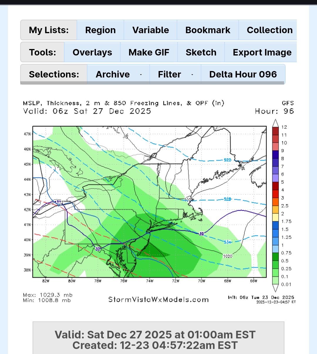
AI gfs
-
Central PA Winter 25/26 Discussion and Obs
mahantango#1 replied to MAG5035's topic in Upstate New York/Pennsylvania
34 here currently, don't see this sticking around long. -
Central PA Winter 25/26 Discussion and Obs
mitchnick replied to MAG5035's topic in Upstate New York/Pennsylvania
Started as decent snow around 4:30. Good luck up north of me. I'm sure mine will be washed away....but not yet! -
Started as some decent snow this morning before being washed away shortly. Lol
- Today
-
Possibly the northern mountains but at this time the cold front looks dry. Unless your into skiing then somewhere like Beech mountain. But at this time the models aren't showing any winter weather around New Years.
-

Winter 2025-26 Medium/Long Range Discussion
TheNiño replied to michsnowfreak's topic in Lakes/Ohio Valley
Welp. See y’all in a few weeks. -
You rang.
-

December 2025 regional war/obs/disco thread
WinterWolf replied to Torch Tiger's topic in New England
Thank you for the reasonable post. -

Winter cancelled/uncancelled banter 25/26
coastalplainsnowman replied to Rjay's topic in New York City Metro
I figure this is as safe a place as any to post this. Hear me out.. was just watching Fox Weather for more than 3 minutes straight for the first time. I'll say this much - at 1AM they were covering - wait for it - weather. Talking about the Dec 26/27th threat, naming each of the models, presenting what each is showing. Not taking itself too seriously. Beats the other late night weather options of When Tornadoes Attack or some such nonsense on TWC, or the Accuweather wall to wall equivalent of Local on the 8s interspersed with mattress commercials. Just saying - not the worst thing to have on the telly in the background. What's the saying? Don't @ me bro... -

December 2025 Short/Medium Range Forecast Thread
John1122 replied to John1122's topic in Tennessee Valley
I think we'd all take this, with single digit cold pressing in behind the second clipper. -

E PA/NJ/DE Winter 2025-26 Obs/Discussion
LVblizzard replied to LVblizzard's topic in Philadelphia Region
I don’t really trust globals on the snow/mix line. We’ll have to wait another day or two for the hi-res models to come into range. What does look certain is that this will be an all or mostly frozen event for most of us. WWA just issued for Lehigh/Northampton counties for this morning. NWS expects 1-2” around here.