All Activity
- Past hour
-

Is we back? February discussion thread
TauntonBlizzard2013 replied to mahk_webstah's topic in New England
If you look closely in the background, you can see a certain CT wolf -
If current trends continue someone will get EURO’d tonight lol
-

Feb 4-5 significant SE snow threat
WinstonSalemArlington replied to GaWx's topic in Southeastern States
Great Caesar’s Ghost! -
This is a little different than the cold chasing moisture event a couple weeks ago. In this case the front has already passed through and there’s a secondary LP developing in the colder air. The airmass isn’t nearly as cold as the last couple we’ve used and it’s always delayed over the mountains but I wouldn’t call this a “classic” case of cold chasing moisture
-
I agree with RAH this is a classic cold chasing moisture. Just like 3 weekends ago. I’ll believe it when I see it lol. Youre not sucking me in again
-
if the Lunenburg coop were a deflator
-
Looks like he has some frost on the eye brows.
-

February 2026 Medium/ Long Range Discussion: Buckle Up!
psuhoffman replied to Weather Will's topic in Mid Atlantic
Sometimes a QPF pattern persists all season...sometimes not. Remember 2015, Everyone thought we were toast when all those snows hit north of us through January and early Feb...then it became our turn from Feb 15 into March. That was maybe the most extreme example but it's hit or miss whether the a pattern persists the whole cold season...the problem with using persistence is it works until it doesn't and it's hard to predict when the pattern is going to change until it does. -
I think the key is "certainly worth monitoring." It has potential to be a small to moderate event.
-
As usual has the screw southern wake co look. Don't even care at this point
-
Someone may get NAM’d tomorrow afternoon. It seemed to my faulty memory that secondary lows were common in the 70s and they were always good for a couple of inches.
-
 It’s over. Above 32°.
 -
From RAH. Improved storm signal but climo favors limited accumulation due to nature of cold chasing precip: Both deterministic and ensemble guidance of the GFS/ECMWF/CMC have gotten wetter, which has resulted in more ensemble members producing measurable snow. The best chance would be across the north. However, this is a case of cold air "chasing" the precipitation, which typically results in limited snowfall if any across our area. Still certainly worth monitoring.
-

February 2026 Medium/ Long Range Discussion: Buckle Up!
Ralph Wiggum replied to Weather Will's topic in Mid Atlantic
A Nino with a -AO and possibly -NAO? Sign me up -
February 2026 Medium/ Long Range Discussion: Buckle Up!
psuhoffman replied to Weather Will's topic in Mid Atlantic
The latest CANSIPS was indicating a possible modoki nino. That would increase our chances significantly. -
Temp spiked to 35.9, a couple degrees above guidance. Some decent melting in sunny areas.
-
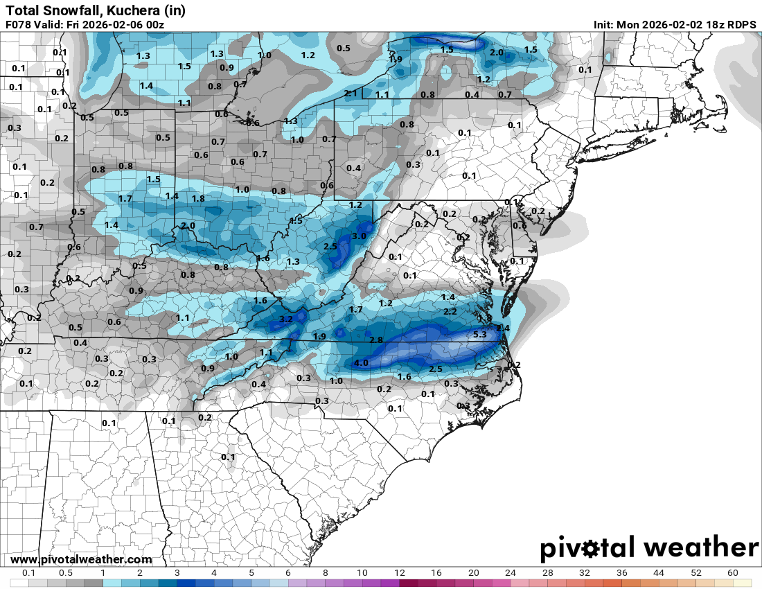
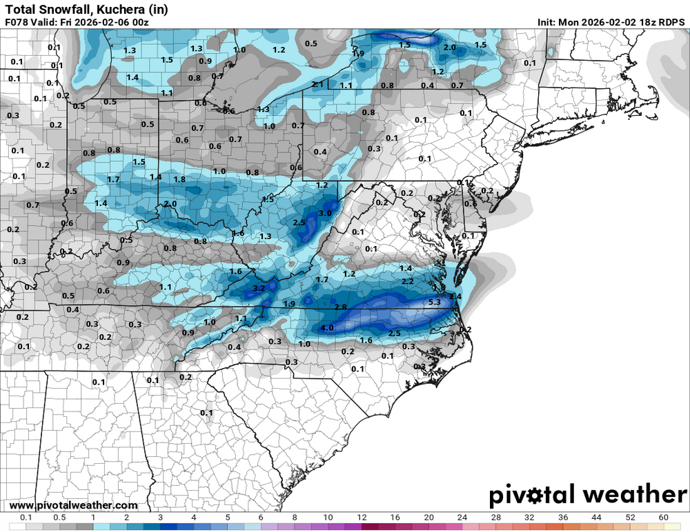
RGEM brings a widespread 3-5 on the south side. 2-4 across most all Hampton roads.
-
Of course, Kuchera will be more accurate, but that's still pretty sweet. I hope somehow Raleigh gets 3"+ just for the memes
-
Been seeing some crazy good skating on Sebago.
-
This was the post that did it for me. He has an unshielded max/min thermometer just sitting out in the middle of the tree farm. I mean of course it’s going to lose more heat at night.
-
Nice improvement at 500 mb on ICON, surface didn’t change much
-
Random stat alert... For the first time since the winter of 1978/79, Chicago has had average or above average snowfall in each month (Nov-Dec-Jan).
-
Poof ...and compaction begins.
-
RGEM bringing the goods now. Oh my lol
-
I went to a hoodie last week and no jacket this afternoon.