All Activity
- Past hour
-
As posted earlier, MJO phase 3 is a plus based on it having been the coldest phase on avg in Feb during La Niña. However, the GEFS progged strong -PNA presents a challenge to getting a significant snow per daily PNAs since 1950. For the 19 DC 3”+ snowstorms during the 40 La Nina or cold neutral Febs since 1950, here were the daily PNAs: 2/11/25 +0.9 2/25-6/14 +0.5 2/13/14 -1.1 2/12/06 +1.7 2/8/97 +0.5 2/16/96 -0.4 2/2/96 +0.7 2/4/95 +1.6 2/24/86 +0.3 2/22/86 -0.4 2/4/75 -0.3 2/8/74 -0.2 2/19/72 -0.5 2/17/72 -0.7 2/2/72 -1.1 2/17/67 +0.3 2/7/67 +0.7 2/13/60 +0.2 2/7/51 +0.3 Median +0.3 Mean +0.2 Highest +1.7 Lowest -1.1 Progged GEFS PNA 2/22-3: ~-1.2 So, should there be 3”+, this would be near the lowest PNA for a Feb 3”+ snowstorm during La Niña. Thus, for a better shot at 3”+, I’d rather the PNA be less negative.
-

E PA/NJ/DE Winter 2025-26 Obs/Discussion
Violentweatherfan replied to LVblizzard's topic in Philadelphia Region
Everyone was on that bandwagon, I remember Paul Kocin on TWC Friday night showing a graphic with SEPA in the bullseye with 2 to 3 feet of snow. Then on Saturday a coworker saying it wasn’t going to snow, and I was like wtf get out of here. -
Warning snow into CNE.
-

Central PA Winter 25/26 Discussion and Obs
Itstrainingtime replied to MAG5035's topic in Upstate New York/Pennsylvania
Actually, no...I was talking about getting 73" from the next storm alone! (The 12z CMC showed a bullseye of 73" over the Delmarva) -

Central PA Winter 25/26 Discussion and Obs
Voyager replied to MAG5035's topic in Upstate New York/Pennsylvania
I agree. 73° would give it an A- Oh wait, you're talking about seasonal snow...my bad. -
Nicw thump on NAM pike area north. Seems to want to get cooler.
-

Late February/Early March 2026 Mid-Long Range
soadforecasterx replied to WxUSAF's topic in Mid Atlantic
I just want Nam to show a crazy amp'd solution just to show some false hope -

“Cory’s in NYC! Let’s HECS!” Feb. 22-24 Disco
CoastalWx replied to TheSnowman's topic in New England
Definitely left stuff on the table. -
Don't believe the stratosphere's been very well correlated beyond coincidence this season and that will remain that way through spring. We may in fact cool down/endure another cold loading into the continent, either way. So it's moot. The EPO is pretty clearly trying to dip neggie for about 3-5 day span - new index indication that's materialized over these recent last three days of prognostics. When/if so, I don't think keeping the cold W in -EPOs is our problem, not with the flow finding least excuse imagined to consummately speed up, if not speed up ...stretch wave lengths. One of those two appears to always exert ... since about 2010 ( actually, I argue the traces of that begin in the super NINO of 1998 but different discussion). So yeah...the early notions of busting out after the 24th (miss?) are probably going to have to be a roll-back on that idea.
-
Snip from LWX's latest AFD... KEY MESSAGE 2... Low pressure tracking nearby brings a slight winter storm threat to the forecast area this weekend. Further cold advection will take place Sunday as a trough dives across the Great Lakes. High temperatures on Sunday will be in the low to mid 40s with overnight lows dropping near or below freezing. An area of low pressure is forecast to develop over the southeast Sunday before deepening and tracking offshore towards New England Sunday night into Monday morning. This low pressure system brings increasing precipitation chances and a slight winter storm threat to the forecast area on Sunday. Models continue to show a wide range of solutions with uncertainty dependent on the strength, track, and timing of the low pressure system. Precipitation will likely begin as rain Saturday night into Sunday morning with snow mixing in overnight. With marginal temperatures throughout the day, the current forecast has a rain/snow mix likely throughout the day with precipitation type becoming primarily snow as temperatures fall Sunday night. Confidence in accumulating snow remains highest in the Alleghenies where temperatures are more favorable, although global guidance continues to show some degree of accumulating snow further east. There has been some increase in the probability of minor impacts via WPC`s probabilistic WSSI. With this event being 4 days out, there remains plenty of time for any variable to change and thus greatly altering the forecast. If this threat materializes, travel disruptions are possible but we will continue monitoring as this event gets closer.
-

“Cory’s in NYC! Let’s HECS!” Feb. 22-24 Disco
Go Kart Mozart replied to TheSnowman's topic in New England
NAM at 51hrs taller ridge out west, apex is further back toward the Chimney area. I need an intervention. -
I love how I saw some sensationalist Accuweather article about a "huge storm" about to hit, come here, and see that it's already deteriorated. Weather media is desperate for eyeballs.
-

“Cory’s in NYC! Let’s HECS!” Feb. 22-24 Disco
Ginx snewx replied to TheSnowman's topic in New England
AN snow and snow depth days BN temps. The way we like our winter -
It's still just a rampaging blizzard at Mammoth today. Today was supposed to be a light snow day, with only 9 inches on the mountain. They are probably close to 70 inches at this point with 2 or so more feet coming tomorrow.
-
I think we can add 2 things to the Fraud Five: coastals that hit the whole region, and run of the mill SWFEs that hit the whole region. Those SWFEs that set up a front along 495/pike/84 with rain SE of that line and 10" of pork snow on the NW side. Used to be so common place 20 years ago.
-
Wednesday Feb 18 Mixed event. NOPE …ain’t happenin’
Ginx snewx replied to HoarfrostHubb's topic in New England
First rain since mid January fantastic winter so far. -
Nobody should ever have faith in any model. But Weathernext was pretty good for some storms this winter.
-

“Cory’s in NYC! Let’s HECS!” Feb. 22-24 Disco
TauntonBlizzard2013 replied to TheSnowman's topic in New England
Yup, we’ve had a couple small events in the last month after the mega SWFE, but for the most part, we’ve squandered opportunities big time. And even before that event, same thing -
The happy hour Nam will save us.
-

Late February/Early March 2026 Mid-Long Range
winter_warlock replied to WxUSAF's topic in Mid Atlantic
Does anyone really even have any faith in this model? -

“Cory’s in NYC! Let’s HECS!” Feb. 22-24 Disco
Scott Koziara replied to TheSnowman's topic in New England
Thanks! Newport had about 8 inches in the January event and maybe 5 in the February event. The February event was a huge bust for anyone west and north of New Bedford with busted forecasts of a foot plus across the entire region. A bust but not as bad as the February 1989 bust. -
High if 36, down to 34 right now, the not hitting 40°F stretch continues worn 4 or 5 inches of solid snow cover still evident... going on nearly 30 days of not hitting 40 since jan 22nd.. Central Park had snow depth of over an inch end yesterday at 23 days, tired at 21st longest with longest ever being 56 days back 2/17/48
-
The Euro is a fantastic model but it’s not infallible and has been on an island / wrong before.
-
This weekend isn't far from trending to something at least light for the upper SE
-
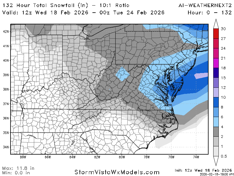
12Z AI Weathernext2 SV: DC 6” vs 8” on 6Z