All Activity
- Past hour
-
Same can be said if it goes into the bad phases. Just a computer model.
-
If I remember correctly, there were a number of storms that just missed central park with snowfall. Even though I believe the city ended up around 4 inches for the year, with subtle differences it could have been much more. Of course the giant blizzard ending April 1st that year was too warm and east for Manhattan (all the other borrows did ok). However if that same storm occurred 2 weeks earlier, Manhattan could have had a solid 6 to 10 inches. Going into this year with low expectations, I would definitely roll the dice with a 96 / 97 repeat.
-
has a weird splotchy look too suspect the answer is bad news
-
(002).thumb.png.6e3d9d46bca5fe41aab7a74871dd8af8.png)
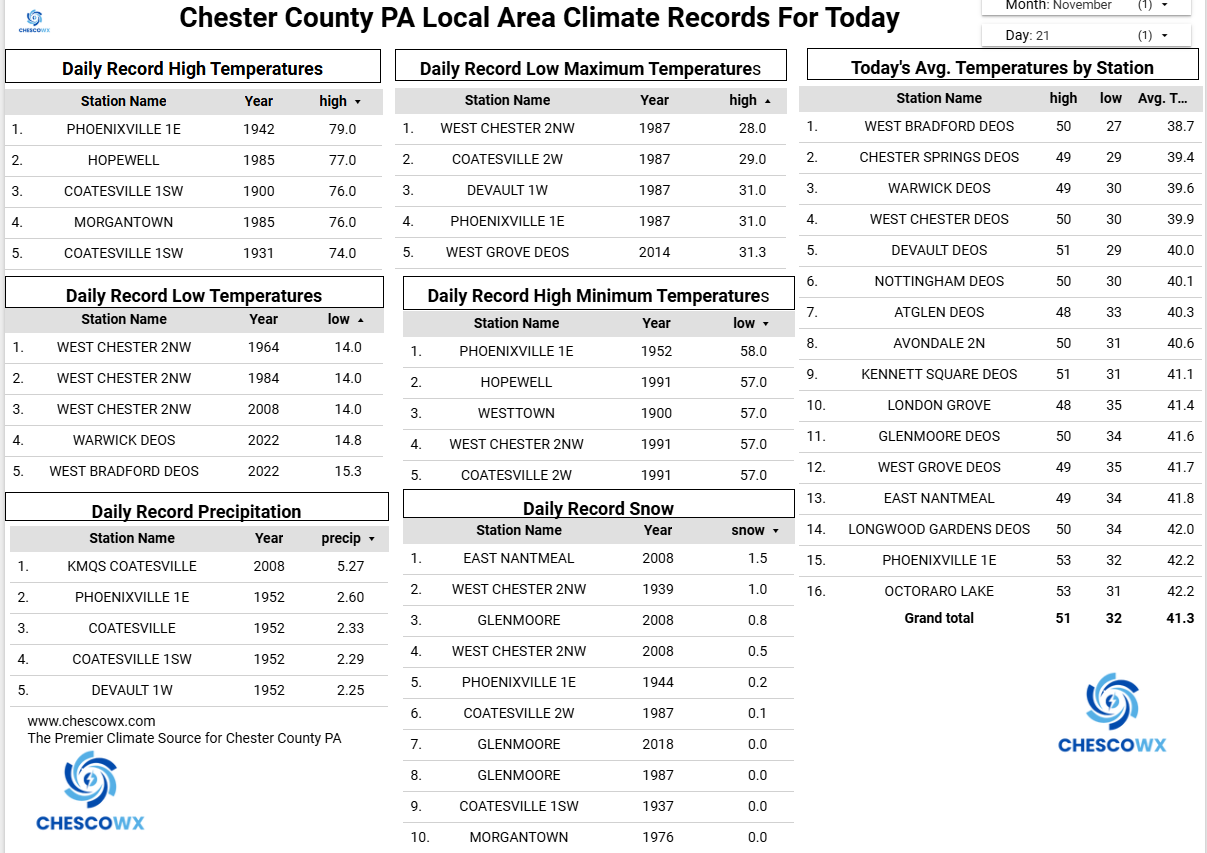
Central PA Fall Discussions and Obs
ChescoWx replied to ChescoWx's topic in Upstate New York/Pennsylvania
We have not had much sun this week and today will be no different. Rain chances increase late tonight with around 0.20" possible for most areas. We should finally see the sun return tomorrow through Monday with afternoon high temperatures near average at around 50 degrees. Our next rain chances increase by Tuesday late day into Wednesday. Wednesday should be our one well above average temperature day with highs reaching near 60 degrees! We turn sharply cooler by Thanksgiving Day.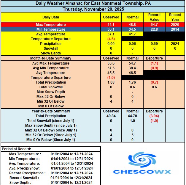

-

Central PA Fall Discussions and Obs
pasnownut replied to ChescoWx's topic in Upstate New York/Pennsylvania
if i may, its cooldown part 2. verbatim we cool for turk day into weekend, then a brief warmup as the calendar turns to Dec. AOA 12/3-4 we get 500mb pattern depicted above. -
E PA/NJ/DE Autumn 2025 Obs/Discussion
ChescoWx replied to PhiEaglesfan712's topic in Philadelphia Region
We have not had much sun this week and today will be no different. Rain chances increase late tonight with around 0.20" possible for most areas. We should finally see the sun return tomorrow through Monday with afternoon high temperatures near average at around 50 degrees. Our next rain chances increase by Tuesday late day into Wednesday. Wednesday should be our one well above average temperature day with highs reaching near 60 degrees! We turn sharply cooler by Thanksgiving Day.
-

November 2025 general discussions and probable topic derailings ...
dendrite replied to Typhoon Tip's topic in New England
It’s been kinda low grade consistently below normal this month. CON’s min so far is 18F. They usually have gotten lower than that by now.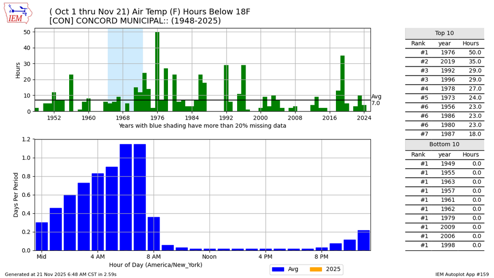
-

Central PA Fall Discussions and Obs
Superstorm replied to ChescoWx's topic in Upstate New York/Pennsylvania
Is that on track or pushed out a week? . -
Don't think I've ever seen this much drought throughout the entire country. Where the hell have all the weather systems gone?

-

Central PA Fall Discussions and Obs
mahantango#1 replied to ChescoWx's topic in Upstate New York/Pennsylvania
picked up .01 from that mist. -
.thumb.png.4150b06c63a21f61052e47a612bf1818.png)
November 2025 general discussions and probable topic derailings ...
HIPPYVALLEY replied to Typhoon Tip's topic in New England
Morning low of 21°. November has certainly featured some chilly mornings. -
Yes that's definitely occurring. Hopefully we can get the PDO to return to a more neutral if not slightly positive state in the long term.
-
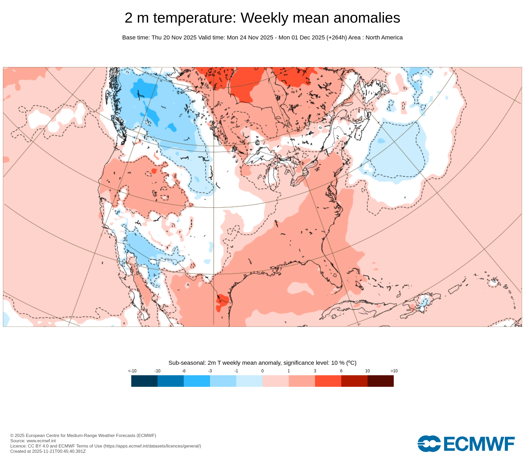
Looks like a little warmer than average as we head into the last week of November. Storm track remains through the Great Lakes. So the warm ups will be a bit more impressive than the cool downs which follow. But nothing too extreme in terms of temperatures and storms.

-
November 2025 general discussions and probable topic derailings ...
dendrite replied to Typhoon Tip's topic in New England
Min 20.9°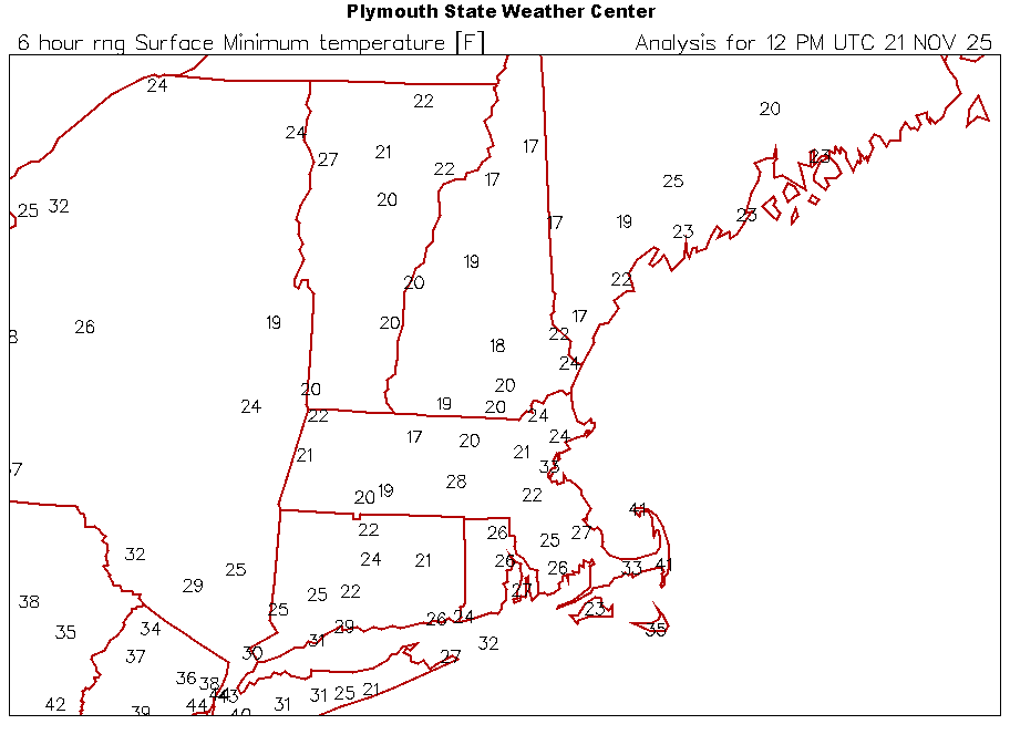
-
That post had nothing at all to do with the tropospheric MJO. It was the stratosphere only, which Simon Lee believes (in his professional opinion) resembles 96-97. But with regard to the MJO, we won’t know for certain that the MJO actually goes strongly into phase 8 until it happens, it’s simply a computer generated projection right now
-

2025-2026 ENSO
donsutherland1 replied to 40/70 Benchmark's topic in Weather Forecasting and Discussion
Simon is highly credible with deep expertise. He doesn't make outlandish statements for clicks or subscriptions. He has done important research. I am aware of his concerns and take them seriously. With regard to the upcoming SSWE, I have outlined what is my current baseline thinking. Overall, I have three general scenarios: Scenario 1: Great Lakes Focused Cold, East Gets a Window (EPO-/AO-/PNA-) -- My Baseline Scenario 2: Colder/Blockier; Classic Eastern Winter Period (EPO-/AO-/PNA+) Scenario 3: Delayed or Short Impact/Persistent SE Ridge; Cold Underperforms in the East; reduced snow opportunities in the Mid-Atlantic Region (EPO-/AO+/PNA-) Under my current baseline, cold would first move into the Great Lakes Region and then spread farther east (except for the Southeast; the cold will be fleeting there). The late November cold shot is unrelated to the stratospheric event. Should the forecast AO- break down relatively quickly, the odds of Scenario 3 would increase. Given guidance skill (lack thereof) at long timeframes, I am sticking with the baseline until there is credible evidence it is going off track. Interestingly, during Winter 1996-1997, January was the coldest month relative to normal for such cities as Detroit and New York. That outcome was suggested by my final winter analog set. -
This isnt 1996/1997 Strong into P8 Dont expect a strong PV
-
Yeah, we've noticed the muting of torches as they get closer in time. I think it is because the Pacific is improving. We just need the Atlantic to cooperate with timing.
-
My man, the sage voice of reason.
-

Central PA Fall Discussions and Obs
Jns2183 replied to ChescoWx's topic in Upstate New York/Pennsylvania
It has now been misting here for 14 straight hours Sent from my SM-G970U1 using Tapatalk - Today
-

November 2025 general discussions and probable topic derailings ...
Kitz Craver replied to Typhoon Tip's topic in New England
It’s coming… -
To be clear, I'm not debbing on this winter. We have several favorable factors working in our favor thus far, and as @WxUSAF has noted these torches advertised in the medium to long range have been muted as we close on the date.
-

Major Hurricane Melissa - 892mb - 185mph Jamaica landfall
olafminesaw replied to GaWx's topic in Tropical Headquarters
Looks like EF4 type damage with cinder block construction torn down. This area was in the "weaker" western eyewall. At a similar altitude to where that 250 mph wind gust was measured -
Models really struggle with the December forecast progression of the pattern in late November. That’s why I would like to see everything play out over the next few weeks before getting too excited this early. Let’s see what the Euro monthly comes up with on the December 5th release. There is a bit of a late November forecast barrier for getting the mid into late December patterns correct. Since we can go back to most years at this time in the long range forecasts and watch numerous changes as the calendar actually gets into the first 5 days or so of December. Plus we have the backdrop of only 3 Decembers in the last 14 years that lead to major I-95 snowstorms since 2011. So December has faced some challenges for the snowfall after having 7 out of 11 snowy years between 2000 and 2010.
-
You guys need to relax. Look at euro ensembles by day 15. Even a cold Dec 1-5 is still probably cold rain. Just be patient