All Activity
- Past hour
-
After scrolling and smash, just make a run for it barefoot! Here's another offbeat clip, Reed throws up in his mouth after a close call: https://x.com/Nerdy_Addict/status/1924982658649543083 I have no idea why and what is happening, Reed doesn't seem to be the type to get shook from a close call. It reminded me how there was a report that during a chase he had a seizure years ago, no closure on that either.
-
More than likely because they are updating AWIPS this week and couldnt reschedule.They gave the public advance notice because some things might be down at times along with NOAA radio the next few days
-

May 17th-20th severe weather discussion
CheeselandSkies replied to Chinook's topic in Central/Western States
Booked PTO to chase this Sunday-Monday back on May 9th. Managed to get there in time for the beauty near Arnett (@andyhb was on it as well). Then, hours after I thought the day was done, tried tangling with the Haviland-Plevna nocturnal beast when it was cycling northwest of Pratt. Quickly thought better of that and booked a room in Pratt for the night just as it was ramping back up. -
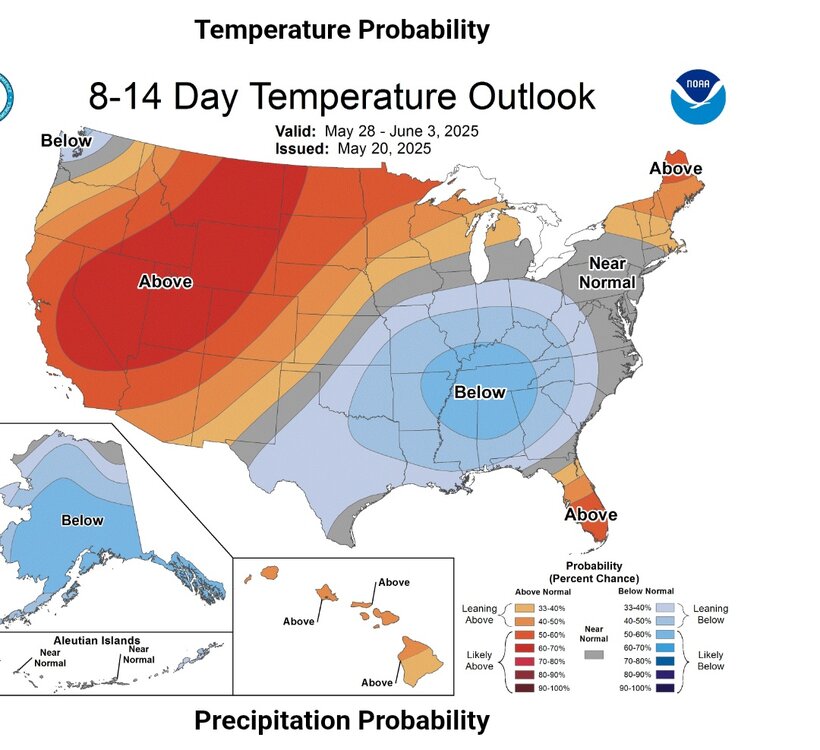
I think there’s pretty good agreement about upper 70s/low 80s to end May or start June. The GFS appears to be greatly overdone with the heat.
-
It might be interesting to watch the timing of the end of this pattern. Some of the models are indicating a quick turn-around into summer at the very end of May and during the first week of June. While one must be skeptical because this pattern has been so stubborn to leave, it can't last forever. WX/PT
-
I think this is possible. WX/PT
- Today
-
I’m down with nice and cool/enjoy it while we can while the Antarctic ice finally grew for the first time in a decade
-
Every single day it's not snowing is amazing and a blessing. Saturday looks blessed.
-
Saturday looks like crap. Self destructing sun and shower risk.
-
Severe Weather Statement National Weather Service Huntsville AL 915 PM CDT Tue May 20 2025 ALC049-071-210230- /O.CON.KHUN.TO.W.0051.000000T0000Z-250521T0230Z/ Jackson AL-DeKalb AL- 915 PM CDT Tue May 20 2025 ...A TORNADO WARNING REMAINS IN EFFECT UNTIL 930 PM CDT FOR SOUTHEASTERN JACKSON AND EAST CENTRAL DEKALB COUNTIES... At 914 PM CDT, a confirmed tornado was located near Henagar, or 7 miles north of Fort Payne, moving east at 35 mph. HAZARD...Damaging tornado and half dollar size hail. SOURCE...Law enforcement confirmed at least tornado between Sylvania and Henagar. IMPACT...Flying debris will be dangerous to those caught without shelter. Mobile homes will be damaged or destroyed. Damage to roofs, windows, and vehicles will occur. Tree damage is likely. This tornado will be near... Fort Payne around 920 PM CDT. Other locations impacted by this tornadic thunderstorm include Dutton, Desoto State Park, Valley Head, Mentone, Hammondville, and Pine Ridge. PRECAUTIONARY/PREPAREDNESS ACTIONS... To repeat, a tornado is on the ground. TAKE COVER NOW! Move to a basement or an interior room on the lowest floor of a sturdy building. Avoid windows. If you are outdoors, in a mobile home, or in a vehicle, move to the closest substantial shelter and protect yourself from flying debris. && LAT...LON 3451 8553 3450 8555 3450 8556 3449 8556 3448 8558 3447 8557 3447 8558 3443 8558 3449 8598 3463 8607 3467 8607 3469 8555 3454 8551 TIME...MOT...LOC 0214Z 270DEG 30KT 3457 8568 TORNADO...OBSERVED MAX HAIL SIZE...1.25 IN $$ KTW This is another in a series of long tracked supercells that are training through Jackson, Marshall, and Dekalb counties in northeast Alabama. The local law enforcement agencies in the area have confirmed a tornado is on the ground between Henager and Fort Payne moving towards I-59.
-
Saturday Sunday and Monday don’t look terrible. Could definitely be worse, and did look worse about a week ago. Looks like some actual warmth coming towards the end of next week
-
Severe Weather Statement National Weather Service Huntsville AL 850 PM CDT Tue May 20 2025 ALC049-071-210230- /O.CON.KHUN.TO.W.0051.000000T0000Z-250521T0230Z/ Jackson AL-DeKalb AL- 850 PM CDT Tue May 20 2025 ...A TORNADO WARNING REMAINS IN EFFECT UNTIL 930 PM CDT FOR SOUTHEASTERN JACKSON AND CENTRAL DEKALB COUNTIES... At 850 PM CDT, a confirmed tornado was located over Section, or 7 miles northwest of Rainsville, moving east at 35 mph. HAZARD...Damaging tornado and half dollar size hail. SOURCE...Broadcast media confirmed tornado. IMPACT...Flying debris will be dangerous to those caught without shelter. Mobile homes will be damaged or destroyed. Damage to roofs, windows, and vehicles will occur. Tree damage is likely. This tornado will be near... Sylvania, Powell, and Rainsville around 855 PM CDT. Henagar around 900 PM CDT. Fort Payne around 910 PM CDT. Other locations impacted by this tornadic thunderstorm include Dutton, Langston, Mentone, Desoto State Park, Valley Head, Hammondville, and Pine Ridge. PRECAUTIONARY/PREPAREDNESS ACTIONS... To repeat, a tornado is on the ground. TAKE COVER NOW! Move to a basement or an interior room on the lowest floor of a sturdy building. Avoid windows. If you are outdoors, in a mobile home, or in a vehicle, move to the closest substantial shelter and protect yourself from flying debris. && LAT...LON 3451 8553 3450 8555 3450 8556 3449 8556 3448 8558 3447 8557 3447 8558 3443 8558 3450 8609 3467 8607 3469 8555 3454 8551 TIME...MOT...LOC 0150Z 270DEG 30KT 3457 8593 TORNADO...OBSERVED MAX HAIL SIZE...1.25 IN $$
-
I loved this hot wx, even in the early 80's kindergarten. Never complained, was perfect!
-
I'm definitely in shape lol I fucking hate anything above 85 , if it's dry and breezy it's awesome but stagnant hot city air is terrible
-
I know not of whom you speak.
-
I expect the 798hr cfs from you in July.
-
Meh it's almost time for the heat and dews.. but let's not forget in 73 days it's August 1st and I'll be posting every long range GFS cold front I see
-
Yeah it's a weird pattern. Tried to wade through the prognostic discussion but got a popsicle headache. It's probably one lonely meteorologist in his garage in College Park these days.
-
I actually felt some humidity this evening, but it was the right amount and calm wind. Three ball weather.
-
Severe Weather Statement National Weather Service Huntsville AL 822 PM CDT Tue May 20 2025 ALC049-071-095-210145- /O.CON.KHUN.TO.W.0048.000000T0000Z-250521T0145Z/ Marshall AL-Jackson AL-DeKalb AL- 822 PM CDT Tue May 20 2025 ...A TORNADO WARNING REMAINS IN EFFECT UNTIL 845 PM CDT FOR NORTHEASTERN MARSHALL...SOUTHERN JACKSON AND CENTRAL DEKALB COUNTIES... At 822 PM CDT, a confirmed tornado was located over Section, or 7 miles southeast of Scottsboro, moving east at 35 mph. HAZARD...Damaging tornado and golf ball size hail. SOURCE...Emergency management confirmed tornado. IMPACT...Flying debris will be dangerous to those caught without shelter. Mobile homes will be damaged or destroyed. Damage to roofs, windows, and vehicles will occur. Tree damage is likely. This tornado will be near... Rainsville, Henagar, Sylvania, and Powell around 830 PM CDT. Other locations impacted by this tornadic thunderstorm include Dutton, Langston, Paint Rock, and Pine Ridge. PRECAUTIONARY/PREPAREDNESS ACTIONS... To repeat, a tornado is on the ground. TAKE COVER NOW! Move to a basement or an interior room on the lowest floor of a sturdy building. Avoid windows. If you are outdoors, in a mobile home, or in a vehicle, move to the closest substantial shelter and protect yourself from flying debris. && LAT...LON 3452 8633 3456 8631 3457 8633 3458 8630 3459 8630 3460 8633 3466 8633 3470 8573 3445 8572 TIME...MOT...LOC 0122Z 268DEG 32KT 3459 8595 TORNADO...OBSERVED MAX HAIL SIZE...1.75 IN $$ KTW
-
The NWS Huntsville, Hytop NWS radar is down due to the severe weather. Any storms will have to be tracked via composite data from the NWS Birmingham, NWS Atlanta/Peachtree City radars.
-
That end of May early June period looks more promising. Far enough out that I don't trust it yet but most modeling showing a heat signal. Not sure of the duration tho'...
-
I just want it warm … with light lingering breezes extending into the evenings, and the promise of 64 at dawn going to the mid 80s the next day, and the day after that.
-
Yeah I’m ready for Kevin to be trolling ACATT daily.
-
Can’t wait for the heat and dews


.thumb.png.4150b06c63a21f61052e47a612bf1818.png)
