All Activity
- Past hour
-

2025-2026 Fall/Winter Mountain Thread
Maggie Valley Steve replied to Buckethead's topic in Southeastern States
I headed up to Waterrock Knob today to check out the leaf progression. There is some change with a few trees beginning to show changes towards vibrant reds, orange and yellow. We're probably about 10 to 15 days away from peak at elevation. Surprisingly around the house, Poplar are turning yellow and brown and beginning to fall. That late August cold spell did it's work! -
Yeah, too hot.
-
-
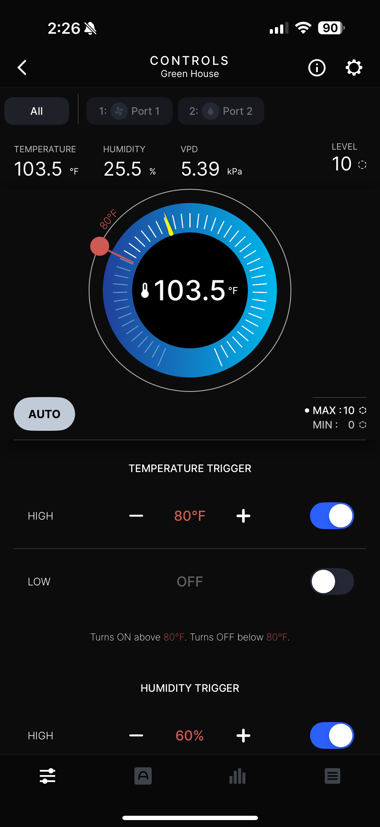
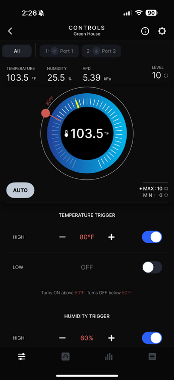
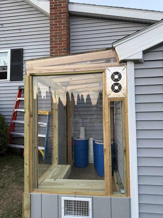
Ha ha, Yes, Going to use passive heat to heat this winter too, Let the sun do the work, Quite warm in there today.
-
0.99”
-
Those are some pretty low probs for MSS (massena) and EFK (newport) given the guidance.
-
Looks great! U fancy. I have the frame from an old trampoline and some plastic.
-

E PA/NJ/DE Autumn 2025 Obs/Discussion
MGorse replied to PhiEaglesfan712's topic in Philadelphia Region
A total of 0.26" of rain yesterday. Better than 0.00" -
-
Just finished a small greenhouse as well to winter the citrus trees, Will start the seedlings for the garden too next spring.
-
Don’t see any tropical stuff, but end of next week does look rainy on the guidance. Precisely when is tbd.
-
That 42 for PWM could translate to a frost for me. I usually run 3-4° cooler on rad nights. Too close for comfort. We have a s-load of flowers and seedlings that are slated for sale. Looks like we'll be covering them. Sheet mulching the (non GYX obs) grass we have left out back and making a mini greenhouse before spring so won't be an issue next year.
-
Remind me please... what are you at since 8/1 (12z cococrahs)?
-

September 2025 OBS-Discussion centered NYC subforum
NorthShoreWx replied to wdrag's topic in New York City Metro
0.13" rainfall from yesterday's event. 2.68" total so far for September. It's been a month since we used a/c, although September has been nice but not really that chilly. Lowest temp has been 51° on 9/9. We've had one day with maxT in the 60's (65 on 9/7). August had 1 such day (68° on 8/20), July had none (closest was 79° on the 10th and 27th), and June had 5. The last sub-50° day was 49° on June 3 (following 47° on June 2). Max Temperatures have been more impressive, although this year's "heat waves" (subjectively) didn't seem to last long. Hottest days were: June 24 - 101° (100.8°, hottest June day I have seen) July 29 - 98° June 25 - 97° July 30 - 96° July 25 - 95° August touched 90 only once (90.0° on 8/11. 8/13 came close at 89.6°). If you want to call 8/13 90° and add a day to the total, I won't argue. We've had 16 90° days this year: May - 0 June - 6 July - 9 August - 1 September - 0 Lest these stats imply a cool summer, through August 17 there were also 12 days with a max of 88° or 89°. We haven't come close to those high temperatures since 8/17 and the past month has been rather nice. Another 6 weeks of neither needing to use air conditioning nor heating to maintain a good temperature inside the house would be nice. Location: north Smithtown, NY -
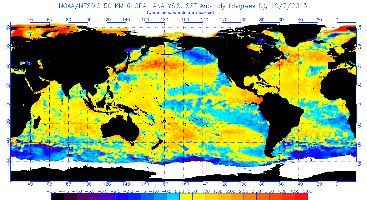
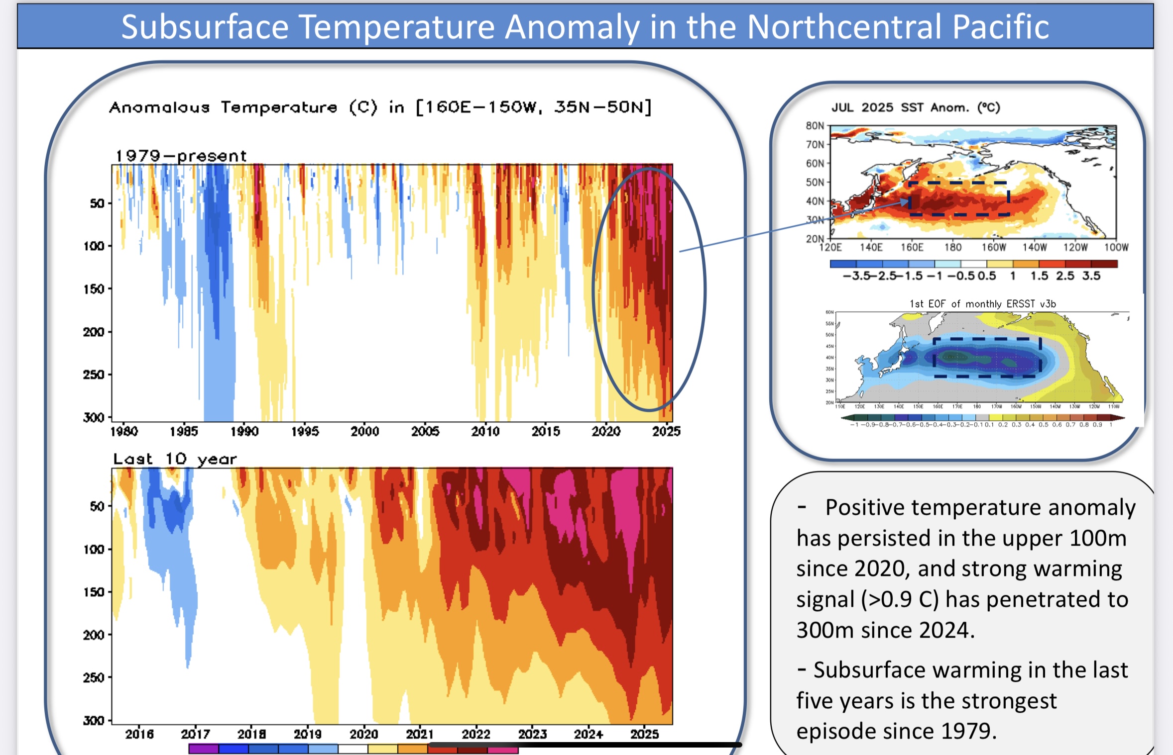
The funny part to me is that 2013 actually did do that. Similar timing. There seems to be this notion in here that there was this static warm pool in the NE Pacific for months on end that year. When that was not the case from what I've been seeing looking back at the data.

-
The .53" yesterday elevates my September total to .60". That's 22% of normal for Sept. 18.
-
Ok experts, whats the forecast looking like for OC MD next (26-28) weekend? Headed to Oceans Calling, hoping we don't get a 'cane coming up the coast.
-

September 2025 OBS-Discussion centered NYC subforum
FPizz replied to wdrag's topic in New York City Metro
Cleared out nicely and the temp is up to 81. Jetting out of work a little early to play 18 with my son. I'm annoyed, there were 2 ambient stations that I like to compare to mine right on my road, but one went offline a few days ago. I might be a weirdo and knock on the guys door and ask if he needs a battery to get it back up and running, haha -
I think the warm blobs can begin to exert some influence on the pattern when they become anchored to the subsurface like we are seeing now across most of the WPAC to North of Hawaii. Last winter we had one of the deepest troughs for the last 20 years emerge to the east of Japan. The surface SSTs didn’t cool very much compared to past deep trough instances since the subsurface had accumulated to much heat. So the strong gradient remained between the area east of Japan and Siberia. This lead to frequent jet extensions. Plus when the record SSTs are located near the Kuroshio Current in the WPAC and Gulf Stream in the Atlantic, they can help to initiate Rossby wave breaking which have a big influence on hemispheric circulation patterns. https://www.cpc.ncep.noaa.gov/products/GODAS/ocean_briefing_gif/global_ocean_monitoring_current.pdf

- Today
-
Yes, right....the western warm pool incites convective action over the MC, which mimics cool ENSO. No argument there....all I was saying is that it's easier to get a cool ENSO like expression than it is warm ENSO....but we require a stronger ENSO signal for it to be the primary catalyst these days, yes.
-
Got up to 69 here - mostly sunny. 72 tomorrow and Saturday. Everyone here is acting like it’s peak summer - and there is no chance of rain so that is my fault.
-
Haven't had a day with 1"+ since early December; first year to get past June without at least one. Since the light showers on 9/7, not a drop.
-
Going to mow the lawn possibly for the last time this weekend, Only been mowed twice in the last 6 weeks, Chance of a frost this weekend would be the icing on the cake to end the grow season officially.
-
I'm aware of that but .. I don't believe they have that right. The ENSO and the La Nina apparent fingerprint is coincidental in that sense - not being forced by the ENSO state/thermal distribution as it terminates into the westerlies. It just so happens to be that in the absence of either, there is a feeble ONI that encourages upwelling over the eastern Pac but it doesn't really reflect a La Nina. Makes it exceedingly difficult to parse the two apart, sure.. because the expanding HC and the break down of that device/organized circulation machinery, lends to a residual SS stressing that orients E --> W In other words, the correlation is too linear.
-

2025 Atlantic Hurricane Season
NorthHillsWx replied to BarryStantonGBP's topic in Tropical Headquarters
If the follow up wave does not develop, there are some mild concerns down the road it might ride the low level flow further west and develop closer to home. Some ensemble support for development in SW Atlantic from the lemon highlighted by NHC. With everything else pretty dead, at least something to watch