All Activity
- Past hour
-
I am wondering if it’s a grass allergy (though she’s been rolling around in the grass for the few weeks we’ve had her). She did eat a pup cone a few hours ago which is a peanut butter flavor. Was thinking bee sting but the skin doesn’t have any bumps. It’s just the fur
-
Yeah or did she roll or lay in something that irritated the skin on that side. I wouldn’t be too worried. But sometimes a quick trip to the vet is the best for your own mental well-being.
-
hives? maybe allergic to something she ate or got into? try and shave off some of the fur and see what the skin looks like..or just take to vet
-
78/48 brilliant
-
Texted the vet but a little worried. Never saw this. I was going to google it too but every time you google this stuff the return is usually some doom and gloom worst case scenario
-
Did a Google image and found this thread on reddit..
-
The weekly drought monitor is going to start being of interest across a wide part of the sub given the dryness. We need some rain soon.
-
Has anyone seen this happen with a dog before? Her fur is like bubbled up. She doesn’t seem in any pain or distress. Can’t feel anything on her skin

-

2026-2027 Strong/Super El Nino
chris21 replied to Stormchaserchuck1's topic in Weather Forecasting and Discussion
97-98 was a massive winter for my area in the southern Appalachians (100 inches plus) which shows the potential such an ENSO outcome could produce. -
40.2 at 6:15.
-

2026-2027 Strong/Super El Nino
GaWx replied to Stormchaserchuck1's topic in Weather Forecasting and Discussion
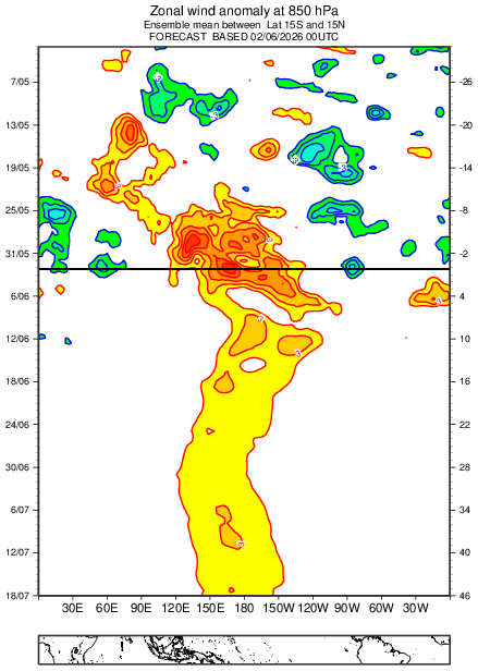
Here we go folks. June 2nd was the 2nd day in a row of a steep warming in 3.4 (another 0.09) (RONI up to ~+0.7C). That makes it a two day warming total of 0.18C! It hasn’t warmed at this rate since way back in mid-April. A notable but delayed warming after the start of a long and strong -SOI period is common and was in addition to model hints why I said on Monday before this two day rise to expect after the prior 15 day pause next week’s weekly 3.4 update to be a few ticks warmer: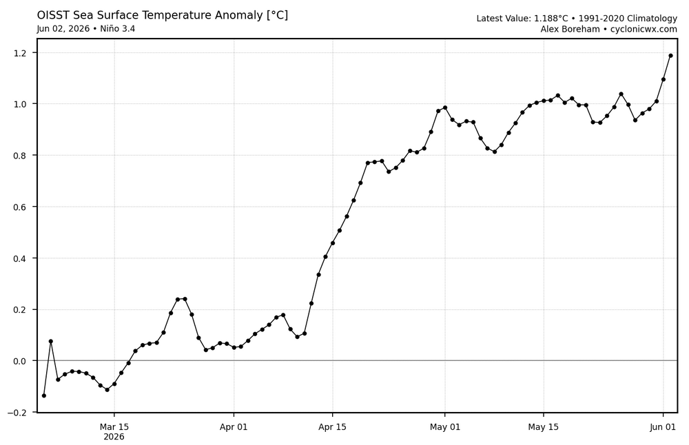
-
Perfection
-
The "wheel of misfortune" cut off still trying ruin it for Scott!
-
Well it is almost officially summer after all. Enjoy!
-
52 this morning. Felt fantastic on my run. Can't beat that for early June.
-

2026-2027 Strong/Super El Nino
snowman19 replied to Stormchaserchuck1's topic in Weather Forecasting and Discussion
- Today
-
Nice day, could be better yet could be much worse. Take
-
77° / 41° under clear blue skies. Doesn't get much better.
-

Central PA Summer 2026 Discussion/Obs Thread
WmsptWx replied to Voyager's topic in Upstate New York/Pennsylvania
Euro apparently showing the HEAT mid-month with GFS getting warmer, too. -
Chamber of Commerce Top 5 day!
-
Thank you Tip, I enjoyed the Op Ed. As a cement bound URI blessed denizen of the coastal plain I credit you with, sadly, a most accurate description of my cool/cold season, “four months of Autumn”. On the coastal plain this is less likely to be tongue-in-cheek. Unfortunately, as described by Hawkeye Pierce that Crab Apple Junction Maine has a white Christmas, beginning October 31st may also be less likely, nowadays. Still……. When the first real cold and threat of frozen, a flake, a mix and maybe accumulation appears, our local media, as do our forums, whoosh into a joyous anticipation. i, personally, find solace, in a calm warm summer night with gently falling showers. “Speak to me softly, like the rain” …… I still try to listen. As always…..
-
June 3 1955: Seven people are killed on Lake Traverse when their boat is overturned by strong winds from a thunderstorm. For Wednesday, June 3, 2026 1921 - A cloudburst near Pikes Peak CO killed 120 people. Pueblo CO was flooded by a twenty-five foot crest of the Arkansas River, killing 70 persons. Fourteen inches of rain was reported at Boggs Flat, where a hard surface road through nearly level country was washed out to a depth of seven feet. (The Weather Channel) 1959 - Thunderstorms in northwestern Kansas produced up to eighteen inches of hail near Salden during the early evening. Crops were completely destroyed, and total damage from the storm was about half a million dollars. Hail fell for a record eighty-five minutes. The temperature dropped from near 80 degrees prior to the storm to 38 degrees at the height of the storm. (David Ludlum) 1987 - Six days of flooding in South Texas culminated with five to six inch rains from Bexar County to Bandera County, and five to nine inches rains in Gonzalez and Wilson Counties. Total crop damage was estimated at 500 million dollars. (Storm Data) (The National Weather Summary) 1988 - Early morning thunderstorms in southern Texas produced wind gusts to 86 mph at Port Isabel, and wind gusts to 83 mph at South Padre Island. Unseasonably hot weather prevailed from the Southern Plateau Region to the Northern High Plains. Fourteen cities reported record high temperatures for the date. (Storm Data) (The National Weather Summary) 1989 - Thunderstorms developing over the Southern Plains Region during the afternoon hours produced severe weather into the night. Thunderstorms spawned eleven tornadoes, and there were 169 reports of large hail and damaging winds. Thunderstorm winds gusted to 80 mph at Newcastle, OK, and Wilson, OK. Softball size hail was reported at Monahans, Childress and Groesbeck TX. Monahans TX reported six million dollars damage. Five inches of rain deluged Geronimo OK. (The National Weather Summary) (Storm Data)
-

2026-2027 Strong/Super El Nino
LakePaste25 replied to Stormchaserchuck1's topic in Weather Forecasting and Discussion
-
There is some child-like novelty to the first snow and holiday snows, and occasionally interesting events, otherwise its just a beat down of darkness and nasty
-
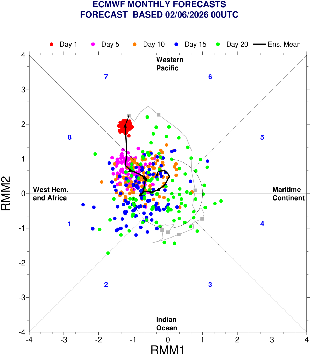
2026-2027 Strong/Super El Nino
LakePaste25 replied to Stormchaserchuck1's topic in Weather Forecasting and Discussion
The EPS in particular seems to have a westward lean on the OLR map, which would push the RMM mean into the COD. I see less of a signal of this on the GEFS.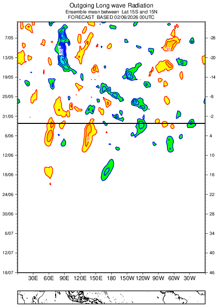


.thumb.gif.f92b16c631a1d15d405ed77b33f0710d.gif)