All Activity
- Past hour
-
12z mostly sweet suite - onto 18z
-
My take on all the models is they all have their strengths and weaknesses - so I prefer using NBM (National Blend of Models)
-

“Cory’s in NYC! Let’s HECS!” Feb. 22-24 Disco
Sey-Mour Snow replied to TheSnowman's topic in New England
was just going to say that to him.. like you said better than having it in the GOM right now . -

Wednesday Feb 18 Mixed event. NoP refresher?
HoarfrostHubb replied to HoarfrostHubb's topic in New England
Maybe it will be a dry day. Lol -
wow just checked one hour later and the snow is really coming down and blowing all over the place blizzard like conditions
-
Track of 500 feature is ideal....as indicated. Remains to be seen how close to reality it is come Sunday night and Monday. A track as indicated would deliver the goods!
-

“Cory’s in NYC! Let’s HECS!” Feb. 22-24 Disco
mahk_webstah replied to TheSnowman's topic in New England
It’s Tuesday. The general direction of this will be clear tomorrow not today. -

E PA/NJ/DE Winter 2025-26 Obs/Discussion
Newman replied to LVblizzard's topic in Philadelphia Region
This 96-132 hour range is where we've been at on a few occasions this winter, and ever since the beginning of weather tracking itself, that models begin to trend towards less favorable outcomes. I'd say 8 or even 9 times out of 10 when a MECS/HECS is seemingly looking likely, it falls apart in this specific hour range. It's all fun and games until the NAM is in range. There is no such thing as a rug pull at this point, we have so long to go. One of the more discouraging shifts in NWP in recent years has been the lack of confidence gained from some ensemble guidance. And what I mean is the EPS and GEFS tend to follow the OP or be incredibly underdispersive. The Euro AIFS ENS isn't as bad in that regard, which is encouraging because it came in looking great at 12z and NW of the OP. Despite some gripes with them, the ensembles are truly our best form of guidance at this range if you know how to use them. These pretty snow maps from the deterministic models are fun to look at, but they're purely entertainment at this range. With that in mind, if you blend the EPS, Euro AIFS ENS, GEFS, and CMC Ens... You find that you're basically split 50/50 on a hit or miss. The good news? The EPS has been trending towards the big solutions. And the GEFS is just a bad model, so who cares lol. -
Canadians Para

-
Sunny here - came out about an hour ago 47 / 37 Foggy night in store
-
Post more please Post less please
-

Wednesday Feb 18 Mixed event. NoP refresher?
powderfreak replied to HoarfrostHubb's topic in New England
Those are some borderline thermals. -
Hey @stormtracker I guess this potential storm is gonna be my thread...lol So Iet me know if/when ya deem it necessary to start one (perhaps if it's still there by Thursday 12z?). I have my doubts but I'll give it a shot
-
Records: Highs: EWR: 69 (2022) NYC: 68 (2022) LGA: 66 (1976) JFK: 65 (1976) Lows: EWR: 0 (1979) NYC: -5 (1896) LGA: 2 (1979) JFK: 5 (1979) Historical: 1894: According to Grazulis, an estimated F2 tornado hits 5 miles south of Warren, Arkansas. An older woman was killed in one of the small homes that were destroyed. In addition, fruit trees were ripped out and carried a half-mile. Another tornado, estimated F3, killed two people in Claiborne County, Louisiana. 1926: A deadly avalanche, Utah's worst, demolishes 14 miner's cottages and a three-story boarding house in Bingham Canyon. Thirty-six were killed and 13 injured. 1930 - Eureka, CA, reported an all-time record high of 85 degrees, a record which lasted until September of 1983. (The Weather Channel) 1936 - The temperature at McIntosh SD plunged to 58 degrees below zero to establish a state record. (David Ludlum) 1958 - The greatest snowstorm of the mid 20th century struck the northeastern U.S. The storm produced 30 inches of snow in interior New England, including more than 19 inches in 24 hours at the Boston Airport. The same storm produced up to three feet of snow in the Middle Atlantic Coast Region, with 14 inches at Washington D.C., and 15.5 inches at Baltimore MD. The storm resulted in 43 deaths and 500 million dollars damage over the Middle Atlantic Coast States. (David Ludlum) 1958: From the 14th through the 17th, one of the most significant snowstorms of the mid 20th century struck the northeastern U.S. The storm produced 30 inches of snow in the interior of New England, including more than 19 inches in 24 hours at the Boston Airport. The same storm produced up to three feet of snow in the Middle Atlantic Coast Region, with 14 inches in Washington D.C. and 15.5 inches in Baltimore, Maryland. The storm resulted in 43 deaths and 500 million dollars damage over the Middle Atlantic Coast States. 1973: Snow showers moved across southeast Texas, with most locations only reporting snow flurries. However, the Houston Intercontinental Airport measured 1.4 inches of snow. 1987 - A couple of winter storms, one off the Atlantic coast and another over the south central U.S., produced snow and ice from the Mississippi Valley to the Mid Atlantic Coast Region. Freezing rain produced a coat of ice three inches thick in northern South Carolina, and 30,000 homes around Pee Dee were left without electricity. Parts of south central Kentucky were without electricity for three days following the storm, which was their worst in 35 years. (The National Weather Summary) (Storm Data) 1988 - Santa Ana winds in southern California gusted to 63 mph at Ontario. Heavy snow blanketed parts of Colorado, with 11 inches reported at Strontia. (The National Weather Summary) (Storm Data) 1989 - Low pressure off the Washington coast produced more than a foot of snow in the Cascade Mountains, and more than three inches of rain along the Northern Pacific Coast. Spokane WA was blanketed with 13 inches of snow. Cold arctic air in the Upper Midwest produced all-time record high barometric pressure readings of 31.10 inches at Duluth MN, 31.09 inches at Minneapolis MN, and 31.21 inches at Bismarck ND. (The National Weather Summary) (Storm Data) 1990 - The biggest winter storm of the season hit the Pacific Coast Region. In northern California, snow fell along the coast, and two day totals in the mountains ranged up to 67 inches at Echo Summit. Snowfall totals in the mountains of southern California ranged up to 48 inches at Green Valley, with 46 inches reported at Big Bear. Up to two feet of snow blanketed the southern Cascade Mountains of Oregon, and 20 to 35 inches were reported in the northern Cascades of Oregon. Up to ten inches of snow blanketed Seattle WA. (The National Weather Summary) (Storm Data)
-
first day over 45 here since early November I believe, came close in January but just under, that's a hell of a run under 45 degrees, a huge avalanche of snow came off the church down the street and creamed a couple cars pretty bad, it was like a 20x30x16" plate of snow, crazy.
-
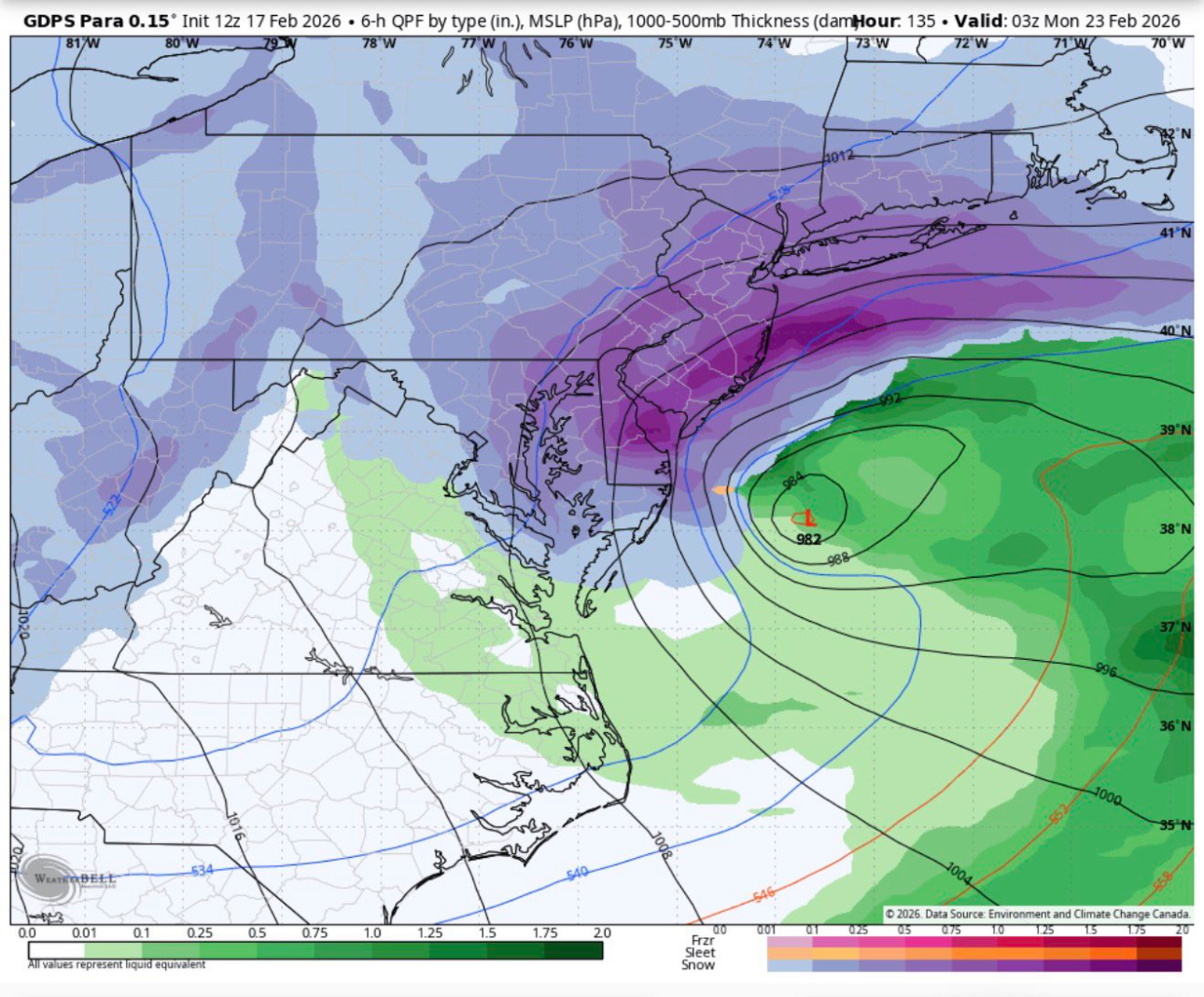
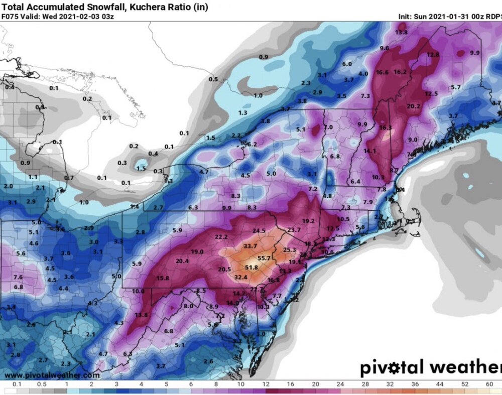
Have to careful with some of the real end outcomes coming out in the models. GDPS is calling for 30”+ for my area. In 2021 it did something similar (RDPS) only it called for 50” so there is an history with that model. Actual storm amounts ranged from 24-36” where I am.
-

Wednesday Feb 18 Mixed event. NoP refresher?
CoastalWx replied to HoarfrostHubb's topic in New England
Pretty much a full cancel everywhere -
They seem to because they actually do as they have much snowier climo, of course, and thus get much more on average. Some there, just as seems to be the case in most subforums, are almost always mad. If they don’t reach climo they’re mad, which keeps them from enjoying what they do get. Thus in their own minds, they almost always “need” more. Some southerners move north for more snow. But then many of them feel the need to get much more in order to be as content. When despite getting more snow than in the S they don’t reach climo, they’re often no happier than they were in the south and sometimes madder! Why can’t they just enjoy the higher amounts vs what they got before?
-
you got the image?
-
an example the euro sucks is winter of 2025-26 not one time has it been right! Also my question to you is would you want euro or euro ai on your side?
-
Weathernext shows a big storm
-

Wednesday Feb 18 Mixed event. NoP refresher?
ineedsnow replied to HoarfrostHubb's topic in New England
18z HRRR is ugly -

Central PA Winter 25/26 Discussion and Obs
WmsptWx replied to MAG5035's topic in Upstate New York/Pennsylvania
GFS was laughably off with the precip shield over Panama City on Tuesday of the week of that storm, I believe. Euro had it early, GFS came late. -

“Cory’s in NYC! Let’s HECS!” Feb. 22-24 Disco
RUNNAWAYICEBERG replied to TheSnowman's topic in New England
Yea. It’s slipping away for a big one WOR. Still can get a good event out here though. -
“Cory’s in NYC! Let’s HECS!” Feb. 22-24 Disco
Sey-Mour Snow replied to TheSnowman's topic in New England
6-10" based on shade