All Activity
- Past hour
-
Please take to the “Chester County bickering “ thread. Again. Please. .
-
Euro also goes east and drier. Seems to be the theme at 18z. Wondering if today’s over performance is the reason for tomorrows downtrend
-

Another Coating of Snow Saturday - "It's all we Got"
VivaManchVegas replied to Sey-Mour Snow's topic in New England
Well at least your car does not have another dose of salt to suck the life out of it. -

First Legit Storm Potential of the Season Upon Us
wxsniss replied to 40/70 Benchmark's topic in New England
Relax man, this feels a bit like amplifying a disagreement out of thin air... (a strength of this forum is the enrichment of ENTPs?) Preponderance of legacy physics models Wed-Friday last week had Jan 18 a graze or completely out to sea vs. AI guidance almost invariably had a substantial advisory-warning hit across the southeast and more. The move of legacy models towards the AI guidance at 12z today suggested AI guidance could be correct, obviously with verification TBD. You're reiterating the point I made multiple times: a major weakness of AI guidance is that how a solution is achieved is opaque, and we can't point to a physics-based mechanism for why they are consistent or change. In any case, this field is at least something kind of evolving and cool to distract us from the latest of a series of disappointing winters. I haven't looked at guidance since 12z, but my current take for Sunday: generally 2-4" eastern SN, spots 3-6" on south shore and Cape, 2-3" around Worcester area and less further west Hoping at least for some Foxboro snow mojo of yore... -
Last NAM run
-
With tomorrow’s storm it’ll be best winter since 2022 because December was cold and we’re back to cold now. But it only feels like a great winter because of how warm and snowless the 2020s have been
-

Storm potential January 17th-18th
sussexcountyobs replied to WeatherGeek2025's topic in New York City Metro
Members are talking about the same thing in 2 different threads. I believe it's time to make a dedicated thread for tomorrow. Just to have clarity. -

First Legit Storm Potential of the Season Upon Us
TauntonBlizzard2013 replied to 40/70 Benchmark's topic in New England
Euro AI east -

Another Coating of Snow Saturday - "It's all we Got"
rimetree replied to Sey-Mour Snow's topic in New England
About 3.5" from both rounds. Nice wintery evening. 32/31 -
I've got some beers from Aslin and Solace in the fridge
-
Unfortunately, CPC now almost entirely refuses to used any 1900s analogs. They broke down on the 6-10 day analog package and was partially used 1994. 2014 was partially incorporated for the 6-10. 2010 was partially used for d8-14. The fly in the ointment is drought. That said, I think the STJ will give us a few chances. The d6-10 window is AN precip FWIW.
-
I mean yay that we have another nickel and dime event, but I'm ready for the main course.
-
@donsutherland1 In a shocking turn of events….the WWB isn’t as strong as it was hyped to be:
-

First Legit Storm Potential of the Season Upon Us
Damage In Tolland replied to 40/70 Benchmark's topic in New England
Sure but that has nothing to do with the morning snow -
41 here and clouding up.
-

Central PA Winter 25/26 Discussion and Obs
WmsptWx replied to MAG5035's topic in Upstate New York/Pennsylvania
Sigh.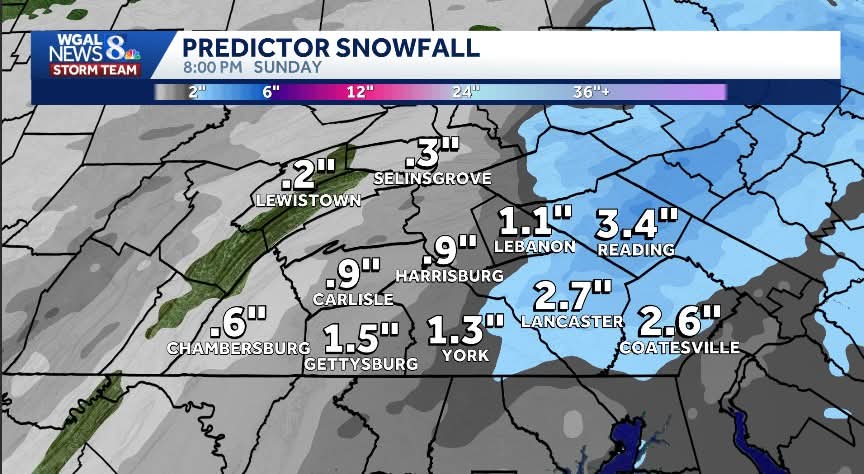
-
CPC d8-14 and d6-10 analog probability maps for temps.
-

January 2026 regional war/obs/disco thread
cleetussnow replied to Baroclinic Zone's topic in New England
The LR pattern depictions should viewed like an art dealer examining a work they think is fake. -

Storm potential January 17th-18th
weatherpruf replied to WeatherGeek2025's topic in New York City Metro
i wouldn't go that far; its been piddly events for lots of us followed by a dry warm stretch. hopefully that is turning around. today we got a surprise 2.2 inches imby, if RU is accurate; when i emerged from the theater, after suffering through 3 hours of avatar, wondering when it would end, i was shocked to see plowable snow; the mall was busy too. i. guess we're around 10-12 for the season. we would need a lot more of these events to get to seasonal average here; i think we have been in a drier climate a few years, so a big daddy is probably unlikely, though i lucked out in feb 2024 with that 10-12 inch storm. -
4.7" at Canistear Reservoir in Vernon, NJ.
-
Lean on ensembles after D5 folks…
-
1” in Syosset
-
Yes it does.
-
Just looking through the 12z and 18z suites....there is a very strong signal for possible two shots of cold air that could push near zero temps into our forum area. This fits with recent Nina winters. I will wait a couple of days before fully embracing that look, but for now...I would say confidence is growing that very cold air may pay us a visit. Need about 48 hours more of model runs to be sure.
-
Next weekend has big overrunning potential .


