All Activity
- Past hour
-
Great day here sunny and 74
-
65-70 in Tolland. Good luck to him.
-

2025 Spring/Summer Mountain Thread
wncsnow replied to Maggie Valley Steve's topic in Southeastern States
I'm under it now. Nasty -
Nothing can stop me I'm all the way up.
-
Hyde and Elias into the sun.
-

2025 Spring/Summer Mountain Thread
Met1985 replied to Maggie Valley Steve's topic in Southeastern States
West Asheville area Sent from my SM-G998U using Tapatalk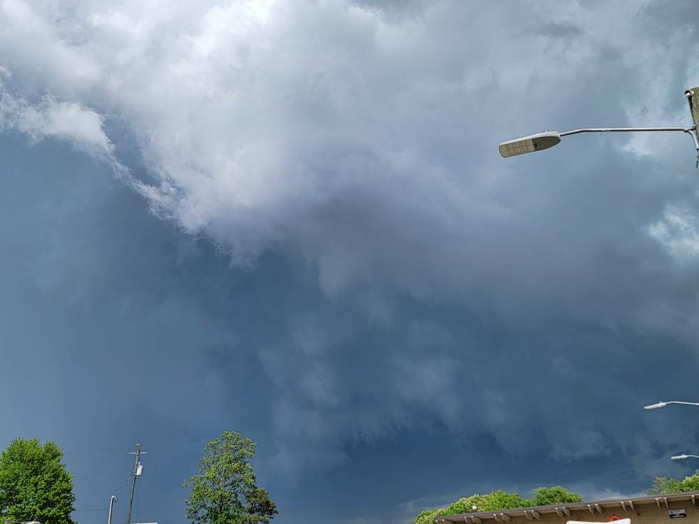
-

E PA/NJ/DE Spring 2025 Obs/Discussion
RedSky replied to PhiEaglesfan712's topic in Philadelphia Region
Great day today after all the media gloom and doom forecast -
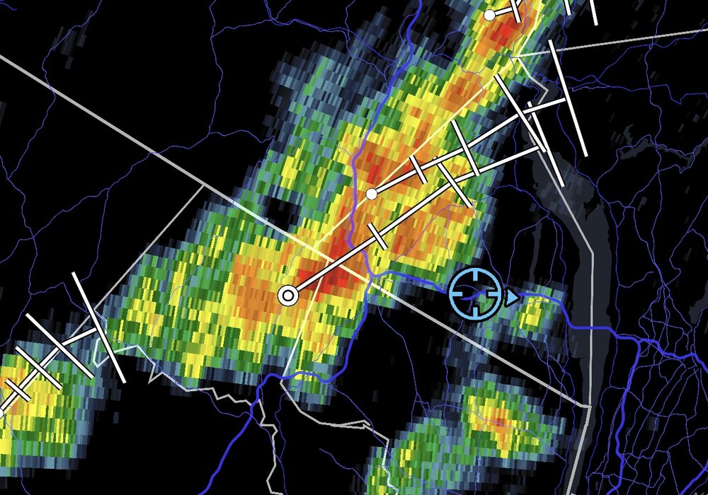
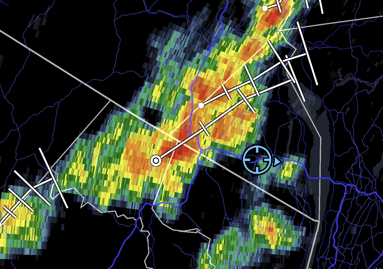
time for me to get in on the fun Special Weather Statement National Weather Service New York NY 358 PM EDT Thu May 8 2025 NYZ067>070-082030- Putnam NY-Rockland NY-Northern Westchester NY-Orange NY- 358 PM EDT Thu May 8 2025 ...A STRONG THUNDERSTORM WILL IMPACT NORTHERN WESTCHESTER... SOUTHEASTERN ORANGE...WESTERN PUTNAM AND ROCKLAND COUNTIES THROUGH 430 PM EDT... At 357 PM EDT, Doppler radar was tracking a strong thunderstorm over Pomona, or near New City, moving northeast at 10 mph. HAZARD...Wind gusts up to 40 mph and pea size hail. SOURCE...Radar indicated. IMPACT...Gusty winds could knock down tree limbs and blow around unsecured objects. Locations impacted include... New City, Peekskill, Monsey, Haverstraw, Suffern, West Point, Sloatsburg, Cold Spring, Pomona, Yorktown Heights, Spring Valley, Stony Point, Jefferson Valley, Putnam Valley, and West Haverstraw.
-
Are we forecasting your Davis or ASOS sites?
-
All guidance has 60”s. You’re going down on this one
-
Just remember how steady it was this week with 4-8” . It’ll bust again
-
Lol what? On Saturday? Lmao . Friday sure
-
Same, the one to your south glanced to my west with maybe 5 sprinkles on windshield.
-
2025 Spring/Summer Mountain Thread
Met1985 replied to Maggie Valley Steve's topic in Southeastern States
Severe storms are blowing up. -
Looks like some hail with that cell
-
Maybe hrrr is right for 57 in Tolland.
-
You’ll be lucky for low 50s.
-
Some Thunder just now with that cell just west of me in Windham County
-
Sun will be out by late morning here. 65-70 sunny/ partly cloudy pm
-
peaked at 74.8° a few min ago. Weekend looks decent overall, aside from early Saturday.
-
0.02 so far today
-
Meh but Sunday looks good
-
blessed
-
As soon as I logged in I heard the crickets lol. I'm tracking a lonely storm west of DC that's moving in my general direction. I'm sure the forcefield will vaporizer it.
-
anddd it continues